Oakfield, Wisconsin
| Oakfield, Wisconsin | |
|---|---|
| Village | |
| Coordinates: 43°40′39″N 88°34′57″W / 43.67750°N 88.58250°WCoordinates: 43°40′39″N 88°34′57″W / 43.67750°N 88.58250°W | |
| Country | United States |
| State | Wisconsin |
| County | Fond du Lac |
| Area[1] | |
| • Total | 0.98 sq mi (2.54 km2) |
| • Land | 0.98 sq mi (2.54 km2) |
| • Water | 0 sq mi (0 km2) |
| Elevation[2] | 860 ft (262 m) |
| Population (2010)[3] | |
| • Total | 1,075 |
| • Estimate (2012[4]) | 1,075 |
| • Density | 1,096.9/sq mi (423.5/km2) |
| Time zone | Central (CST) (UTC-6) |
| • Summer (DST) | CDT (UTC-5) |
| Area code(s) | 920 |
| FIPS code | 55-58925[5] |
| GNIS feature ID | 1583839[2] |
| Website |
villageofoakfield |
Oakfield is a village in Fond du Lac County, Wisconsin, United States. The population was 1,075 at the 2010 census. The village is located within the Town of Oakfield.
History
A post office called Oakfield has been in operation since 1850.[6] The village was named for a grove of oak trees near the original town site.[7]
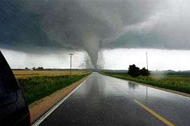
On July 18, 1996, an F5 tornado known as the Oakfield Tornado ripped through the village.[8]
Geography
Oakfield is located at 43°41′3″N 88°32′54″W / 43.68417°N 88.54833°W (43.684167, -88.548551).[9]
According to the United States Census Bureau, the village has a total area of 0.98 square miles (2.54 km2), all of it land.[1]
Demographics
| Historical population | |||
|---|---|---|---|
| Census | Pop. | %± | |
| 1880 | 315 | — | |
| 1910 | 522 | — | |
| 1920 | 556 | 6.5% | |
| 1930 | 577 | 3.8% | |
| 1940 | 655 | 13.5% | |
| 1950 | 697 | 6.4% | |
| 1960 | 772 | 10.8% | |
| 1970 | 918 | 18.9% | |
| 1980 | 990 | 7.8% | |
| 1990 | 1,003 | 1.3% | |
| 2000 | 1,012 | 0.9% | |
| 2010 | 1,075 | 6.2% | |
| Est. 2015 | 1,073 | [10] | −0.2% |
2010 census
As of the census[3] of 2010, there were 1,075 people, 392 households, and 307 families residing in the village. The population density was 1,096.9 inhabitants per square mile (423.5/km2). There were 415 housing units at an average density of 423.5 per square mile (163.5/km2). The racial makeup of the village was 96.9% White, 0.2% African American, 0.3% Native American, 0.4% Asian, 0.3% from other races, and 2.0% from two or more races. Hispanic or Latino of any race were 1.8% of the population.
There were 392 households of which 36.7% had children under the age of 18 living with them, 66.1% were married couples living together, 8.7% had a female householder with no husband present, 3.6% had a male householder with no wife present, and 21.7% were non-families. 19.1% of all households were made up of individuals and 7.9% had someone living alone who was 65 years of age or older. The average household size was 2.74 and the average family size was 3.13.
The median age in the village was 40.3 years. 26.2% of residents were under the age of 18; 8.6% were between the ages of 18 and 24; 22.7% were from 25 to 44; 29.7% were from 45 to 64; and 12.7% were 65 years of age or older. The gender makeup of the village was 49.3% male and 50.7% female.
2000 census
As of the census[5] of 2000, there were 1,012 people, 370 households, and 283 families residing in the village. The population density was 1,049.9 people per square mile (407.0/km²). There were 384 housing units at an average density of 398.4 per square mile (154.4/km²). The racial makeup of the village was 98.42% White, 0.10% Black or African American, 0.30% Native American, 0.30% Asian, 0.59% from other races, and 0.30% from two or more races. 2.87% of the population were Hispanic or Latino of any race.
There were 370 households out of which 39.5% had children under the age of 18 living with them, 63.5% were married couples living together, 7.8% had a female householder with no husband present, and 23.5% were non-families. 20.0% of all households were made up of individuals and 10.8% had someone living alone who was 65 years of age or older. The average household size was 2.74 and the average family size was 3.15.
In the village the population was spread out with 28.5% under the age of 18, 7.0% from 18 to 24, 29.6% from 25 to 44, 23.3% from 45 to 64, and 11.6% who were 65 years of age or older. The median age was 36 years. For every 100 females there were 98.0 males. For every 100 females age 18 and over, there were 101.1 males.
The median income for a household in the village was $51,053, and the median income for a family was $56,154. Males had a median income of $37,833 versus $24,625 for females. The per capita income for the village was $21,131. About 1.1% of families and 1.9% of the population were below the poverty line, including none of those under age 18 and 8.3% of those age 65 or over.
Notable people
- Edson A. Putnam, Wisconsin State Assemblyman, lived in Oakfield.[12]
- Henry A. Ripley, Wisconsin State Assemblyman, lived in Oakfield.[13]
- William F. Sommerfield, Wisconsin State Assemblyman, lived in Oakfield.[14]
References
- 1 2 "US Gazetteer files 2010". United States Census Bureau. Archived from the original on January 24, 2012. Retrieved 2012-11-18.
- 1 2 "US Board on Geographic Names". United States Geological Survey. 2007-10-25. Retrieved 2008-01-31.
- 1 2 "American FactFinder". United States Census Bureau. Retrieved 2012-11-18.
- ↑ "Population Estimates". United States Census Bureau. Archived from the original on June 17, 2013. Retrieved 2013-06-24.
- 1 2 "American FactFinder". United States Census Bureau. Archived from the original on September 11, 2013. Retrieved 2008-01-31.
- ↑ "Fond du Lac County". Jim Forte Postal History. Retrieved 1 March 2015.
- ↑ Chicago and North Western Railway Company (1908). A History of the Origin of the Place Names Connected with the Chicago & North Western and Chicago, St. Paul, Minneapolis & Omaha Railways. p. 109.
- ↑ Dougherty, Terri (1 January 2011). Anatomy of a Tornado. Capstone. p. 20. ISBN 978-1-4296-6281-9.
- ↑ "US Gazetteer files: 2010, 2000, and 1990". United States Census Bureau. 2011-02-12. Retrieved 2011-04-23.
- ↑ "Annual Estimates of the Resident Population for Incorporated Places: April 1, 2010 to July 1, 2015". Retrieved July 2, 2016.
- ↑ "Census of Population and Housing". Census.gov. Archived from the original on May 11, 2015. Retrieved June 4, 2015.
- ↑ 'Wisconsin Blue Book 1876,' Biographical Sketch of Edson A. Putnam, pg. 466
- ↑ 'Wisconsin Blue Book 1899,' Biographical Sketch of Henry A. Ripley, pg. 771
- ↑ 'Wisconsin Blue Book 1913,' Biographical Sketch of William F. Sommerfield, pg. 661
External links
Municipalities and communities of Fond du Lac County, Wisconsin, United States | ||
|---|---|---|
| Cities | 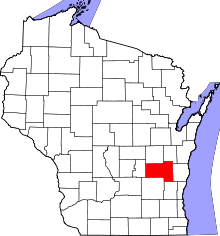 | |
| Villages | ||
| Towns | ||
| CDPs | ||
| Unincorporated communities |
| |
| Ghost towns | ||
| Footnotes | ‡This populated place also has portions in an adjacent county or counties | |