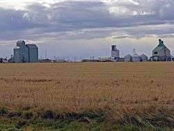
Foremost, Alberta
| Foremost | |
|---|---|
| Village | |
| Village of Foremost | |
 | |
 Foremost Location of Foremost in Alberta | |
| Coordinates: 49°28′44″N 111°26′25″W / 49.47889°N 111.44028°WCoordinates: 49°28′44″N 111°26′25″W / 49.47889°N 111.44028°W | |
| Country |
|
| Province |
|
| Region | Southern Alberta |
| Census division | 1 |
| Municipal district | County of Forty Mile No. 8 |
| Incorporated[1] | |
| • Village | December 31, 1950 |
| Government[2] | |
| • Mayor | Kenneth Kultgen |
| • Governing body | Foremost Village Council |
| Area (2011)[3] | |
| • Total | 1.89 km2 (0.73 sq mi) |
| Elevation[4] | 889 m (2,917 ft) |
| Population (2011)[3] | |
| • Total | 526 |
| • Density | 277.8/km2 (719/sq mi) |
| Time zone | MST (UTC−7) |
| • Summer (DST) | MDT (UTC−6) |
| Postal code | T0K |
| Highways |
Highway 61 Highway 879 |
| Website | Official website |
Foremost is a village in southern Alberta, Canada. It is located 106 km (66 mi) south-west of Medicine Hat, along the Red Coat Trail, in the County of Forty Mile No. 8.
Foremost has a strong agriculture industry. Recreation facilities include an ice arena, swimming pool, curling rink, ice fishing, and ball diamonds. Every June the residents hold a parade, rodeo and tough truck competition. Hockey is a big sport in Foremost. The local team is called the Foremost Flyers. They have multiple provincial and regional titles. The school has a long history of winning sports teams. The Foremost Falcons and Forettes have won many provincial titles in basketball, volleyball, track and field and cross country running. The village also has a strong arts community presenting community theatre as well as a school dramatic department.
Demographics
In the 2011 Census, the Village of Foremost had a population of 526 living in 218 of its 246 total dwellings, a 0.4% change from its 2006 population of 524. With a land area of 1.89 km2 (0.73 sq mi), it had a population density of 278.3/km2 (720.8/sq mi) in 2011.[3]
In 2006, Foremost had a population of 524 living in 233 dwellings, a 1.3% decrease from 2001. The village has a land area of 1.74 square kilometres (0.67 sq mi) and a population density of 301.9/km2 (782/sq mi).[5]
Climate
Foremost experiences a semi-arid climate (Köppen climate classification BSk).
| Climate data for Foremost, Alberta | |||||||||||||
|---|---|---|---|---|---|---|---|---|---|---|---|---|---|
| Month | Jan | Feb | Mar | Apr | May | Jun | Jul | Aug | Sep | Oct | Nov | Dec | Year |
| Record high °C (°F) | 19.1 (66.4) |
22.0 (71.6) |
27.0 (80.6) |
31.1 (88) |
35.0 (95) |
38.9 (102) |
41.1 (106) |
40.6 (105.1) |
36.7 (98.1) |
32.2 (90) |
25.0 (77) |
17.8 (64) |
41.1 (106) |
| Average high °C (°F) | −1.0 (30.2) |
1.6 (34.9) |
6.4 (43.5) |
13.6 (56.5) |
18.9 (66) |
23.0 (73.4) |
26.8 (80.2) |
26.8 (80.2) |
20.5 (68.9) |
13.7 (56.7) |
4.2 (39.6) |
−0.4 (31.3) |
12.8 (55) |
| Daily mean °C (°F) | −7.0 (19.4) |
−4.8 (23.4) |
0.0 (32) |
6.4 (43.5) |
11.6 (52.9) |
15.8 (60.4) |
18.8 (65.8) |
18.7 (65.7) |
12.8 (55) |
6.5 (43.7) |
−1.8 (28.8) |
−6.3 (20.7) |
5.9 (42.6) |
| Average low °C (°F) | −13.1 (8.4) |
−11.1 (12) |
−6.4 (20.5) |
−0.8 (30.6) |
4.3 (39.7) |
8.6 (47.5) |
10.8 (51.4) |
10.6 (51.1) |
5.2 (41.4) |
−0.7 (30.7) |
−7.7 (18.1) |
−12.3 (9.9) |
−1.1 (30) |
| Record low °C (°F) | −42.0 (−43.6) |
−40.0 (−40) |
−35.0 (−31) |
−22.2 (−8) |
−11.1 (12) |
−9.4 (15.1) |
−5.6 (21.9) |
−1.1 (30) |
−12.2 (10) |
−28.0 (−18.4) |
−38.0 (−36.4) |
−43.3 (−45.9) |
−43.3 (−45.9) |
| Average precipitation mm (inches) | 19.8 (0.78) |
13.7 (0.539) |
29.0 (1.142) |
26.0 (1.024) |
55.1 (2.169) |
73.0 (2.874) |
39.7 (1.563) |
40.2 (1.583) |
44.0 (1.732) |
17.4 (0.685) |
18.3 (0.72) |
19.7 (0.776) |
396.0 (15.591) |
| Average rainfall mm (inches) | 0.1 (0.004) |
0.0 (0) |
3.2 (0.126) |
17.1 (0.673) |
49.4 (1.945) |
73.0 (2.874) |
39.7 (1.563) |
39.8 (1.567) |
43.6 (1.717) |
12.1 (0.476) |
1.3 (0.051) |
0.6 (0.024) |
279.9 (11.02) |
| Average snowfall cm (inches) | 19.7 (7.76) |
13.7 (5.39) |
25.8 (10.16) |
8.9 (3.5) |
5.7 (2.24) |
0.0 (0) |
0.0 (0) |
0.3 (0.12) |
0.4 (0.16) |
5.4 (2.13) |
17.0 (6.69) |
19.1 (7.52) |
116.1 (45.71) |
| Source: Environment Canada[6] | |||||||||||||
See also
References
- ↑ "Location and History Profile: Village of Foremost" (PDF). Alberta Municipal Affairs. October 21, 2016. p. 295. Retrieved October 23, 2016.
- ↑ Alberta Municipal Affairs: Municipal Officials Search
- 1 2 3 "Population and dwelling counts, for Canada, provinces and territories, and census subdivisions (municipalities), 2011 and 2006 censuses (Alberta)". Statistics Canada. February 8, 2012. Retrieved February 8, 2012.
- ↑ "Alberta Private Sewage Systems 2009 Standard of Practice Handbook: Appendix A.3 Alberta Design Data (A.3.A. Alberta Climate Design Data by Town)" (PDF) (PDF). Safety Codes Council. January 2012. pp. 212–215 (PDF pages 226–229). Retrieved October 8, 2013.
- ↑ "Canada 2006 Census: Foremost - Community Profile". Statistics Canada. Retrieved June 7, 2007.
- ↑ "Foremost, Alberta". Canadian Climate Normals 1981–2010 (in English and French). Environment Canada. Retrieved March 26, 2014.
External links
 |
Taber | Bow Island | Medicine Hat |  |
| Stirling | |
Nemiscam | ||
| ||||
| | ||||
| Warner | Coutts | Aden |