Forestburg, Alberta
| Forestburg | |
|---|---|
| Village | |
| Village of Forestburg | |
|
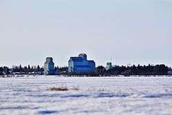
Forestburg grain elevators | |
 Forestburg Location of Forestburg in Alberta | |
| Coordinates: 52°34′49″N 112°04′05″W / 52.58028°N 112.06806°WCoordinates: 52°34′49″N 112°04′05″W / 52.58028°N 112.06806°W | |
| Country |
|
| Province |
|
| Region | Central Alberta |
| Census division | 7 |
| Municipal district | Flagstaff County |
| Founded | 1916 |
| Incorporated[1] | |
| • Village | August 21, 1919 |
| Government[2] | |
| • Mayor | Peter V. Miller |
| • Governing body | Forestburg Village Council |
| Area (2011)[3] | |
| • Total | 2.75 km2 (1.06 sq mi) |
| Elevation | 662.90 m (2,174.87 ft) |
| Population (2011)[3] | |
| • Total | 831 |
| • Density | 302.0/km2 (782/sq mi) |
| Time zone | MST (UTC−7) |
| • Summer (DST) | MDT (UTC−6) |
| Highways | Highway 53 |
| Waterway | Battle River |
| Website | Official website |
Forestburg is a village located in east-central Alberta, Canada. The rich farmland of the area was first settled in 1905. Soon after the first of many "gopher hole" mines, homesteaders were soon coal mining on the banks of the Battle River in 1907.
The site was surveyed in 1919 after the Canadian Northern Railway arrived in 1916, and Forestburg was incorporated into a village. Today Forestburg's economy is based on agriculture, coal mining, oil and gas activity, and power generation. With approximately 75 businesses, the rate of employment is good. Forestburg has a good variety of retail and services, with major employment by Atco Power Ltd. and Westmoreland Coal. The village is the headquarters of the Battle River Railway, a co-operative railway established in 2009.[4]
Demographics
The population of the Village of Forestburg according to its 2014 municipal census is 880,[5] a 5.9% change from its 2011 federal census population of 831.[3]
In the 2011 Census, the Village of Forestburg had a population of 831 living in 348 of its 380 total dwellings, a -7.2% change from its 2006 population of 895. With a land area of 2.75 km2 (1.06 sq mi), it had a population density of 302.2/km2 (782.6/sq mi) in 2011.[3]
In 2006, Forestburg had a population of 895 living in 393 dwellings, a 2.9% increase from 2001. The village has a land area of 2.19 km2 (0.85 sq mi) and a population density of 409.1 inhabitants per square kilometre.[6]
Climate
| Climate data for Forestburg | |||||||||||||
|---|---|---|---|---|---|---|---|---|---|---|---|---|---|
| Month | Jan | Feb | Mar | Apr | May | Jun | Jul | Aug | Sep | Oct | Nov | Dec | Year |
| Record high °C (°F) | 11 (52) |
15 (59) |
20.6 (69.1) |
30 (86) |
35 (95) |
34.4 (93.9) |
36 (97) |
37 (99) |
35.6 (96.1) |
29.5 (85.1) |
20.5 (68.9) |
14 (57) |
37 (99) |
| Average high °C (°F) | −6.8 (19.8) |
−3.4 (25.9) |
2.3 (36.1) |
11.4 (52.5) |
17.8 (64) |
21.5 (70.7) |
23.6 (74.5) |
23.2 (73.8) |
17.4 (63.3) |
11.6 (52.9) |
1 (34) |
−5.1 (22.8) |
9.5 (49.1) |
| Daily mean °C (°F) | −11.9 (10.6) |
−8.5 (16.7) |
−2.5 (27.5) |
5.8 (42.4) |
11.8 (53.2) |
15.8 (60.4) |
17.9 (64.2) |
17.1 (62.8) |
11.7 (53.1) |
6 (43) |
−3.5 (25.7) |
−9.9 (14.2) |
4.1 (39.4) |
| Average low °C (°F) | −16.9 (1.6) |
−13.6 (7.5) |
−7.3 (18.9) |
0.1 (32.2) |
5.7 (42.3) |
10 (50) |
12.1 (53.8) |
11 (52) |
5.9 (42.6) |
0.3 (32.5) |
−7.9 (17.8) |
−14.6 (5.7) |
−1.3 (29.7) |
| Record low °C (°F) | −44.4 (−47.9) |
−42.2 (−44) |
−39.4 (−38.9) |
−25.6 (−14.1) |
−7 (19) |
−3.3 (26.1) |
4.4 (39.9) |
0 (32) |
−6.5 (20.3) |
−21 (−6) |
−32 (−26) |
−45 (−49) |
−45 (−49) |
| Average precipitation mm (inches) | 17.4 (0.685) |
11.3 (0.445) |
16.5 (0.65) |
22.3 (0.878) |
46.1 (1.815) |
79.1 (3.114) |
73.2 (2.882) |
58.4 (2.299) |
38.3 (1.508) |
15 (0.59) |
13.3 (0.524) |
15 (0.59) |
402 (15.83) |
| Source: Environment Canada[7] | |||||||||||||
Notable people
- Evan Oberg, professional hockey player
See also
References
- ↑ "Location and History Profile: Village of Forestburg" (PDF). Alberta Municipal Affairs. October 21, 2016. p. 302. Retrieved October 23, 2016.
- ↑ "Municipal Officials Search". Alberta Municipal Affairs. November 18, 2016. Retrieved November 21, 2016.
- 1 2 3 4 "Population and dwelling counts, for Canada, provinces and territories, and census subdivisions (municipalities), 2011 and 2006 censuses (Alberta)". Statistics Canada. February 8, 2012. Retrieved February 8, 2012.
- ↑ http://www.battleriverrailway.ca/contacts.html
- ↑ "INFOrestburg: Council Highlights" (PDF). Village of Forestburg. July 2014. p. 1. Retrieved July 17, 2014.
- ↑ "Canada 2006 Census: Forestburg - Community Profile". Statistics Canada. Retrieved June 7, 2007.
- ↑ Environment Canada—Canadian Climate Normals 1971–2000, accessed April 3, 2010
External links
 |
Heisler | Strome | Killam | |
| Donalda | |
Amisk | ||
| ||||
| | ||||
| Gadsby | Halkirk | Galahad |