Fort Chambly
| Fort Chambly | |
|---|---|
 | |
| Type | Fort |
| Site information | |
| Controlled by | New France; Great Britain; Canada |
| Site history | |
| Built | 1675 |
| In use | 1675-1776 |
| Battles/wars |
Iroquois Wars — Seven Years' War — Invasion of Canada Campaign — American Revolution |
| Official name | Fort Chambly National Historic Site of Canada |
| Designated | 1920 |
Fort Chambly is a historic fort in La Vallée-du-Richelieu Regional County Municipality, Quebec. The fort is designated as a National Historic Site of Canada.[1] Fort Richelieu was part of a series of five forts built along the Richelieu River. Fort Richelieu is at the mouth of the Richelieu River. Fort Chambly formerly known as Fort St. Louis at Chambly, Fort Sainte Thérèse, and Fort Saint-Jean at Saint-Jean-sur-Richelieu, are on the way. Fort Sainte Anne (Isle La Motte, Vermont) in Lake Champlain is near its source. The forts were built in order to protect travellers on the river from the Iroquois. The region is informally known as la Vallée-des-Forts.
History
Fort Chambly at the foot of the Chambly rapids on the Richelieu River in Quebec, Canada, was built by the French in 1711. It was the last of three forts to be built on the same site. The first — then called Fort Saint Louis — was constructed in 1665 by captain Jacques de Chambly, to protect New France from Iroquois attacks.
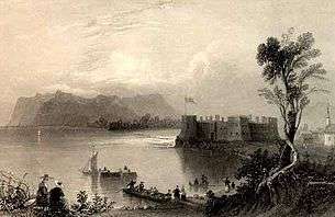
After minor repairs, the fort was burned by the Indians in 1702,[2] but was reconstructed in 1702. By then it was already known as Fort Chambly. However, with the Great Peace of Montreal in 1701, the war between the French and Iroquois was over. Also at this time the War of the Spanish Succession broke out, and boiled over into the colonies of France and England. Thus, to defend against a more powerful European attack, including the threat of cannons, Governor Philippe de Rigaud Vaudreuil ordered that the fort be rebuilt in stone in 1709. The engineer responsible for the design and construction of the new fort was Josué Boisberthelot de Beaucours. He also oversaw major improvements carried out on the fort between 1718 and 1720, modifications he felt would greatly increase the fort's defenses.
For many years Fort Chambly was the main footing of the defensive chain of fortifications along the Richelieu River, which was the easiest invasion route into New France. However, with the construction of Fort Saint-Frédéric (1731) and Fort Saint-Jean (Quebec) (1748) further south, Fort Chambly lost most of its defensive raison d'etre and so was converted into a warehouse and rally-point for soldiers, although the fort was never abandoned. With the Seven Years' War, Fort Chambly was re-fortified and reoccupied, although it failed to stop the British from approaching Montreal and Quebec.
The substantial stone structure which still stands today was lost to the British in 1760 in The Conquest of New France, also known as the French and Indian War.
Captured by American forces on October 20, 1775 during the American Invasion of Canada of 1775-76, it was held until the spring of 1776 when it was evacuated and burned, as the Americans retreated southward to Fort Ticonderoga. Subsequently, prisoners-of-war from the Continental Army, including Colonel William Stacy, were held at Fort Chambly until the end of the American Revolutionary War.
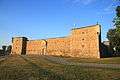
After the Fenian Raids in the 1860s, during which the fort was reoccupied, it was allowed to fall into ruin. In 1882 a citizen of Chambly, Joseph-Octave Dion, personally repaired and restored the site. In the 20th century the Canadian government recognized Fort Chambly's cultural and historical worth and undertook its maintenance. Between 1965 and 1985 extensive archaeological digs were carried out, and today a fully reconstructed version of the final phase of Fort Chambly (1718–1720) is maintained by Parks Canada and is open to the public as the Fort Chambly National Historic Site of Canada.[3]
Legacy
On 28 June 1985 Canada Post issued 'Fort Chambly, Que.' one of the 20 stamps in the “Forts Across Canada Series” (1983 & 1985). The stamps are perforated 12½ x 13 and were printed by Ashton-Potter Limited based on the designs by Rolf P. Harder.[4]
Gallery
 Fort Chambly in the Summer
 Fort Chambly from a distance
 Fort Chambly in Winter
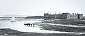 Fort Chambly 1863
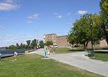 Fort Chambly 2002
 Fort Chambly walls
 Aerial view of Fort Chambly
 Place d'armes and cannon along river
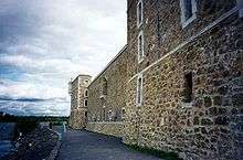 Wall along the Richelieu River
 Fort Chambly cannon
 cannon in Fort Chambly
 View of Fort Chambly in Chambly, Quebec, Canada.
References
- ↑ Fort Chambly. Canadian Register of Historic Places. Retrieved 25 March 2012.
- ↑ Encyclopedia of Quebec History, Fort Chambly - accessed May 31, 2008
- ↑ http://www.historicplaces.ca/visit-visite/affichage-display.aspx?id=13717&page=1 Fort Chambly National Historic Site of Canada
- ↑ Canada Post stamp
Bibliography
- Archaeology at Fort Chambly , by Pierre Beaudet and Celine Cloutier. Ottawa : National Historic Parks and Sites, Canadian Parks Services, 1989
- McHenry, Chris: Rebel Prisoners at Quebec 1778-1783, Being a List of American Prisoners Held by the British during the Revolutionary War, Lawrenceburg, Indiana (1981).
- The Role of Fort Chambly in the Development of New France, 1665-1760 , by Cyrille Gelinas. Ottawa : National Historic Parks and Sites, Canadian Parks Services, 1983
- Dictionary of American History by James Truslow Adams, New York: Charles Scribner's Sons, 1940
- Parks Canada, Fort Chambly National Historic Site brochure, 2007.
- America's Historic Lakes, Fort Chambly on the Richelieu River
- Aimone, Alan, The Siege and Capture of Forts Chambly and St. Johns in 1775, in The Journal of America's Military Past, Vol. 28, No. 2, Fall 2001.
External links
- Official Parks Canada Website - Fort Chambly National Historic Site
- Baudry, René (1979) [1966]. "Chambly, Jacques de". In Brown, George Williams. Dictionary of Canadian Biography. I (1000–1700) (online ed.). University of Toronto Press.
- Google 3D warehouse
Affiliations
| Wikimedia Commons has media related to Fort Chambly. |
The Museum is affiliated with: CMA, CHIN, and Virtual Museum of Canada.
| Provinces | |
|---|---|
| Territories | |
| Other countries | |
| |
Coordinates: 45°26′58″N 73°16′36″W / 45.4495°N 73.2767°W