Fort de Chartres
|
Fort de Chartres | |
|
The gatehouse of Fort de Chartres was reconstructed in the 1930s. | |
  | |
| Location | Randolph County, Illinois, USA |
|---|---|
| Nearest city | Prairie du Rocher, Illinois |
| Coordinates | 38°05′04″N 90°09′28″W / 38.08444°N 90.15778°WCoordinates: 38°05′04″N 90°09′28″W / 38.08444°N 90.15778°W |
| Area | American Bottom |
| Built | 1720 |
| Architectural style | Colonial French Fortification |
| Part of | French Colonial Historic District (#74000772) |
| NRHP Reference # | 66000329[1] |
| Significant dates | |
| Added to NRHP | October 15, 1966 |
| Designated NHL | October 09, 1960[2] |

Fort de Chartres was a French fortification first built in 1720 on the east bank of the Mississippi River in present-day Illinois, it was used as an administrative center for the province. Due generally to river floods, the fort was rebuilt twice, the last time in limestone in the 1750s in the era of French colonial control over Louisiana and the Illinois Country.
A partial reconstruction of the third and last fort, which was built of local limestone shortly before the end of French rule in the Midwest, is preserved in an Illinois state park four miles (6 km) west of Prairie du Rocher in Randolph County, Illinois. It is south of St. Louis, Missouri in the floodplain area that became known as the American Bottom. The site and its associated buildings were placed on the National Register of Historic Places and recognized as a National Historic Landmark on October 15, 1966,[1] and it was named one of the contributing properties to the new French Colonial Historic District in 1974, along with other area French-influenced sites such as the Creole House, the Pierre Menard House, the Kolmer Site (a former Indian village), and the site of Fort Kaskaskia.[3]
The name of the fort honored Louis, duc de Chartres, son of the Regent of France. The fort's stone magazine, which survived the gradual ruin that overtook the rest of the site, is considered the oldest building in the state of Illinois. The state historic site today hosts several large re-enactments at the fort of colonial-era civil and military life each summer.
History

The French
On January 1, 1718, the French government granted a trade monopoly to John Law and his Company of the West. Hoping to make a fortune mining precious metals, the company built a fort to protect its interests. The original wooden fort was built in 1718-1720 by a French contingent from New Orleans, led by Pierre Dugué de Boisbriand. When administration of the Illinois Country was moved from Canada to New Orleans, governance was transferred to the Company of the Indies. The fort was built to be the seat of government and to control the Indians of the region, particularly the Fox. The original fort was a palisade of logs with two bastions at opposite corners.
Within five years, flooding from the Mississippi had left the original fort in bad condition. Construction of a second fort further from the river, but still on the flood plain, began in 1725. This fort was also made of logs and had a bastion at each of the four corners. By 1731 the Company of the Indies had gone defunct and returned Louisiana and its government back to the king. <--The linked article on John Law's company states that he was out of business by 1720.
The second wooden fort deteriorated somewhat less rapidly but by 1742 was in bad repair. In 1747 the French garrison moved to the region's primary settlement 18 miles (29 km) to the south at Kaskaskia. The French debated where to rebuild the fort. When rule of the area reverted to the French crown in the 1730s, officials began to discuss construction of a stone fortress. The government in New Orleans wanted to move the garrison permanently to Kaskaskia, but the local commandant argued for a location near the original site.
The government decided to rebuild a fort in stone near the first forts rather than at Kaskakia. Construction began in 1753 and was mostly completed in 1756; however, construction continued at the site for another four years. The limestone fort had walls 15-ft (3 m)-high and 3-ft (1m)-thick, enclosing an area of 4 acres (16,000 m²). The stone for construction was quarried in bluffs about two or three miles (4 km) distant and had to be ferried across a small lake.
British rule
In 1763 the Treaty of Paris was signed following the Seven Years' War (French and Indian War) and the French transferred control of the Illinois Country east of the Mississippi to Great Britain. (Spain had been granted the western part of the Illinois Country—also known as Upper Louisiana—in the 1762 Treaty of Fontainebleau.) The stone fort had served as center of French administration of the region for only ten years.
The British had difficulty getting a regiment to their newly acquired fort, but on October 10, 1765, a small detachment of the 42nd Royal Highland Regiment commanded by Captain Thomas Stirling took control of the fort and surrounding area. The 42nd was shortly replaced by the 34th Regiment. French Canadian settlers were ordered to leave or get a special license to remain. Many Canadien settlers moved to the more congenial culture of St. Louis.[4][5] The 34th Regiment of Foot renamed the installation Fort Cavendish, after its colonel. However, the post was known as Ft. Chartres from 1768 on, after the 34th were replaced by the 18th (Royal Irish) Regiment under the command of Lt. Col. Wilkins. The British, abandoned the post in May 1772 when the majority of the 18th (Royal Irish) Regiment was ordered back to Philadelphia. A small party under Capt Hugh Lord remained at Kaskaskia until May 1776.[6]
Ruin
The Mississippi continued to take its toll after the fort was abandoned. In 1772 the south wall and bastion fell into the river. The remaining walls deteriorated, and visitors noted trees growing in them by the 1820s. Locals carted away stones for construction over the years. By 1900 the walls were gone. The only part of the original fort that remained was the stone building that had served as the powder magazine.
Reconstruction

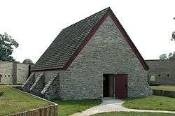
The State of Illinois acquired the ruins in 1913 as a historic site and restored the powder magazine in 1917. The powder magazine is thought to be the oldest existing building in the state of Illinois. In the 1920s foundations of the fort's buildings and walls were exposed. In the late 1920s and through the 1930s, the US WPA rebuilt the gateway and two stone buildings.
A combination museum and office building, constructed in 1928 on the foundation of an original fort building, houses exhibits depicting French life at Fort de Chartres. The large stone “Guards House,” reconstructed in 1936, contains a Catholic chapel furnished in the style of the 1750s, along with a priest’s room, a gunner’s room, an officer-of-the-day room, and a guard’s room. Also on the grounds are an operating bake oven, a garden shed built of upright logs in French Colonial poteaux-sur-solle (French:post on sill) construction, and a kitchen garden with raised beds of produce typical of French 18th-century Illinois.
Partial reconstruction of the fort's walls on the original foundations followed in 1989.[7] The frames of some additional buildings were erected as a display of the post-and-beam construction techniques used for the originals. Other buildings' foundations and cellars were exposed for educational display as well.
Today the site has a museum and small gift shop. It plays host each June to a Rendezvous that is said to be one of the largest and oldest in the country celebrating frontier French and Indian culture.[8]
The site is protected by modern levees, but the Mississippi River is still an occasional menace. The flood of 1993 breached the levee and sent waters fifteen feet deep to lap at the top of the walls.
See also
External links
References
| Wikimedia Commons has media related to Fort de Chartres. |
| Wikinews has related news: Illinois budget cuts to close historic sites and parks |
- 1 2 National Park Service (2006-03-15). "National Register Information System". National Register of Historic Places. National Park Service.
- ↑ "Fort de Chartres". National Historic Landmark summary listing. National Park Service. Retrieved 2008-07-20.
- ↑ Brown, Margaret K. National Register of Historic Places Inventory/Nomination: French Colonial Historic District. National Park Service, n.d., 6.
- ↑ "At Home on the French Frontier", Illinois State Museum Website, Retrieved October 27, 2004.
- ↑ "The Expedition to Fort Chartres", 42nd Royal Highlanders, Inc., of Lafayette, IN website, Retrieved October 27, 2004.
- ↑ "Fort de Chartres State Historic Site", Official website, Retrieved on January 24, 2008
- ↑ "Fort de Chartres", Illinois Historic Preservation Agency site, Retrieved on January 24, 2008
- ↑ "39th Annual Rendezvous". Fort de Chartres State Historic Site. Retrieved 2009-05-27.
| Topics | |
|---|---|
| Lists by states |
|
| Lists by insular areas | |
| Lists by associated states | |
| Other areas | |
| |