Fort Mohave, Arizona
| Fort Mohave | |
|---|---|
| Census Designated Place | |
|
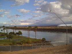
View of Fort Mohave from Avi Resort and Casino | |
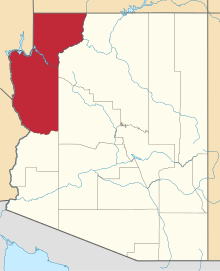
 Fort Mohave Location in the United States | |
| Coordinates: 35°2′35″N 114°37′21″W / 35.04306°N 114.62250°WCoordinates: 35°2′35″N 114°37′21″W / 35.04306°N 114.62250°W | |
| State | Arizona |
| County | Mohave |
| Founded | 1935 |
| Population | 14,364 |
| Time zone | MST |
| ZIP codes | 86426 |
| Area code(s) | 928 |
Fort Mohave is a CDP in Mohave County, Arizona. It is named for a nearby fort that was used during the Mohave War. As of the census[1] of 2010, the population of Fort Mohave was 14,364. This was up from 8,919 in 2000. It is a micro-suburb of Bullhead City. Its recent growth has made it the most populous unincorporated community in Mohave County.[2]
The largest single employer in Fort Mohave is Valley View Medical Center. In 2013, Fort Mohave became the home of a 200+ acre photovoltaic solar generating plant. The plant was built east of Vanderslice Road between Joy Lane and Lipan Boulevard.[3]
History
_(cropped).jpg)
The first known European to visit the area was Spanish explorer Melchor Díaz. He documented his travels in Northwestern Mohave County in 1540.[4] He accounts of meeting a large population of natives who referred to themselves as the Pipa Aha Macav, meaning "People by the River".[5] From "Aha Macav" came the Spanish name Mojave, which was later passed into English, where it is also spelled Mohave. When most people refer to Fort Mohave, they use the spelling "Mohave", while the tribe retains the traditional Spanish spelling "Mojave".
During the Mohave War the fort was established as a base of U. S. Army military operations against the native Mohave people, who had been living in the area for centuries prior. In April 1861, during the early part of the American Civil War, the fort was abandoned, its garrison sent to secure Southern California from possible secession, and then sent to the east. It was subsequently garrisoned by Company B and Company I, 4th California Infantry Regiment, in May 1863. Company B remained for six months but Company I remained until March 1865, when it was relieved by Company C, 7th California Infantry Regiment until 1866 when Camp Mohave was again garrisoned by regular United States Army troops. The U. S. Army remained until September 29, 1890 when the War Department turned it over to the Indian Service by order of President Benjamin Harrison. It was given up by the Indian service in 1935 and is now part of the Fort Mojave Indian Reservation.
Health Care
Fort Mohave is home to Valley View Medical Center, which opened in 2005. It is a 102,000-square-foot (9,500 m2) facility with state-of-the-art technology. The hospital features 38 medical/surgical beds, 10 rehabilitation beds, a six-bed labor and delivery unit, a six-bed intensive care unit, four major operating rooms and two procedure rooms. In 2010, Valley View announced a 1.2 million Emergency Room expansion.[6]

Community

Fort Mohave is home to the Fort Mojave-Mesa Fire Department. It is also home to the largest stadium within 90 miles (140 km), serving all Mohave County for large indoor events, The Mojave Crossing Event Center. It has a seating capacity of 3,000 stadium style and 5,000 arena style.[7]
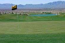
Many neighborhoods in Fort Mohave are built on man-made lakes, golf courses, and mesas with majestic mountain views. The newest golf course, Los Lagos Golf Club, is a Ted Robinson, Sr. Signature Golf Course.[8]
Education
Fort Mohave has two public elementary schools, Fort Mojave Elementary School and Camp Mohave Elementary School, both of which are a part of the Mohave Valley Elementary School District.[9] There is also a public charter school, Young Scholar's Academy,[10] All Beauty College, and the Academy of Building Industries.[11]
Shopping and Dining
Fort Mohave has two large grocery stores, Smith's Food and Drug, Safeway, and a Wal-Mart Supercenter currently under construction. It also has a CVS Pharmacy and an ACE Hardware Store. Restaurants include Red Dragon Chinese Cuisine, Bonanza Cafe, Casa Serrano Mexican Food, an ice cream parlor, and several fast food franchises. Residents of Fort Mohave do the majority of their shopping and dining in Bullhead City, which is considered the shopping hub of the tri-state area.
Demographics
Fort Mohave is geographically between, and demographically connected to, Bullhead City, Arizona and Mohave Valley, Arizona. As of the census[1] of 2010, the population of Fort Mojave was 14,364. This was up from 8,919 in 2000, with 4,049 housing units; a land area of 33.58 square miles (87.0 km2); and a population density of 265.61 people per square mile.[2]
See also
- Bullhead City, Arizona
- Laughlin/Bullhead International Airport
- Laughlin, Nevada
- Mohave people
- Mohave City
- Mohave Valley, Arizona
- Needles, California
- Oatman, Arizona
References
- 1 2 "American FactFinder". United States Census Bureau. Retrieved 2008-01-31.
- 1 2 "86426 (Fort Mohave, AZ 86426) Profile: Maps, Real Estate, Jobs, Schools". Arizona.hometownlocator.com. Retrieved 2012-01-06.
- ↑ "Mohave Daily News article". Retrieved 2012-01-06.(registration required)
- ↑ "New Mexico Office of the State Historian : Diaz, Melchior". Newmexicohistory.org. Retrieved 2012-01-06.
- ↑ "About Us | Fort Mojave Indian Tribe". Mojaveindiantribe.com. 2010-12-05. Retrieved 2012-01-06.
- ↑ "The New Standard of Care - Mohave Valley, Arizona". Valley View Medical Center. Retrieved 2012-01-06.
- ↑ "Mojave Crossing Event Center". Mojavecrossing.com. Retrieved 2012-01-06.
- ↑ "Los Lagos Golf Club - Mojave Valley, Arizona". Loslagoslinks.com. Retrieved 2012-01-06.
- ↑ "Home". Mvesd16.org. Retrieved 2012-01-06.
- ↑ "Young Scholar's Academy". Retrieved 2012-01-06.
- ↑ "Academy of Building Industries - A Public Vocational Charter High School". Aobihs.com. Retrieved 2012-01-06.
- Andrew Edward Masich, The Civil War in Arizona: the story of the California Volunteers, 1861-1865, University of Oklahoma Press, 2006 ISBN 0-8061-3747-9 ISBN 978-0-8061-3747-6.