Walapai, Arizona
| Walapai, Arizona | |
|---|---|
| Unincorporated community | |
 Walapai, Arizona  Walapai, Arizona | |
| Coordinates: 35°20′40″N 113°53′03″W / 35.34444°N 113.88417°WCoordinates: 35°20′40″N 113°53′03″W / 35.34444°N 113.88417°W | |
| Country | United States |
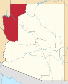
| State | Arizona |
| County | Mohave |
| Elevation | 3,307 ft (1,008 m) |
| Time zone | Mountain (MST) (UTC-7) |
| ZIP code | 86412 |
| Area code(s) | 928 |
| GNIS feature ID | 24678[1] |
Walapai is an unincorporated community on Arizona State Route 66 (former U.S. Route 66) in Mohave County, Arizona, United States. Walapai is located along a railroad line 14 miles (23 km) northeast of Kingman. Walapai has a post office with ZIP code 86412.[2]
References
This article is issued from Wikipedia - version of the 8/7/2016. The text is available under the Creative Commons Attribution/Share Alike but additional terms may apply for the media files.