Forty Fort, Pennsylvania
| Forty Fort, Pennsylvania | |
|---|---|
| Borough | |
|
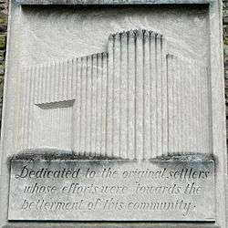
Relief on the Borough Hall | |
 Forty Fort, Pennsylvania | |
| Coordinates: 41°17′0″N 75°52′24″W / 41.28333°N 75.87333°WCoordinates: 41°17′0″N 75°52′24″W / 41.28333°N 75.87333°W | |
| Country | United States |
| State | Pennsylvania |
| County | Luzerne |
| Settled | 1778 |
| Incorporated | 1887 |
| Government | |
| • Type | Borough Council |
| Area | |
| • Total | 1.6 sq mi (4.1 km2) |
| • Land | 1.3 sq mi (3.4 km2) |
| • Water | 0.3 sq mi (0.7 km2) |
| Population (2010) | |
| • Total | 4,214 |
| • Density | 2,700/sq mi (1,000/km2) |
| Time zone | Eastern (EST) (UTC-5) |
| • Summer (DST) | EDT (UTC-4) |
| Zip code | 18704 |
| Area code(s) | 570 |
Forty Fort is a borough in Luzerne County, Pennsylvania, United States. The population was 4,214 at the 2010 census.[1] Its neighbors are the boroughs of Kingston, Wyoming, and Swoyersville. The Wilkes-Barre Wyoming Valley Airport and the Susquehanna River dike are both located in the borough.
History
Forty Fort was named for a Revolutionary War-era fort that the town's original settlers built; there were forty of these settlers from Connecticut, so the town was later named Forty Fort. Forty Fort was prominent in the Pennamite–Yankee War and in the American Revolution. A large stone was placed at the end of Fort St. in 1900 by the Daughters of the American Revolution to mark the approximate location of the fort. In the vicinity of this fort occurred, in 1778, the Battle of Wyoming.[2][3]
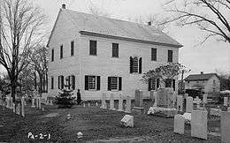
Forty Fort is home to perhaps the oldest building known in northeastern Pennsylvania, the Forty Fort Meetinghouse, located in the borough's cemetery. The meeting house was built in 1806–08. In late October 2005, Forty Fort's Wyoming Seminary Lower School launched a successful attempt to save the building from damage and preserve it as a recollection of past historic memories of Forty Fort. Forty Fort also hosts the historic Nathan Denison house. Denison served as colonel of the militia for the area during the Revolution.
In 1972, Hurricane Agnes delivered inches of rain into the Wyoming Valley, causing the Susquehanna River to overflow its banks. In Forty Fort, a portion of the dike protecting the valley from Susquehanna River broke, causing millions of dollars in damage to Forty Fort and surrounding towns. In addition to structural damage, the Forty Fort Cemetery was heavily affected when over 2,000 caskets were washed away. Recovered bodies were eventually buried in a mass grave with a monument marking the 1972 flood's damage.
Forty Fort has a strong council/weak mayor form of government. Borough Council has seven council members. Elections are split every two years where almost half the council is up for election. It runs with the mayor and three council seats are up for election, then two years later the other four council seats are up for election. Council acts as the legislative branch. The Council is the more powerful branch of the strong council/mayor form of government that Forty Fort employs. The last Borough Council election was in 2015 and the next is 2017.
Transportation
The U.S. Route 11 that stretches from Canada to Louisiana runs across Forty Fort on Wyoming Avenue.
Forty Fort is home to the Wilkes-Barre Wyoming Valley Airport, a public facility serving mainly general aviation aircraft.
Education
Three schools are located in Forty Fort:
- Wyoming Seminary Lower School, a private school suited for pre-K-8th grade
- Dana Street Elementary Center, a public elementary school, part of the Wyoming Valley West School District
- Apple Tree Nursery and Primary School, private school
Geography
Forty Fort is located at 41°17′0″N 75°52′24″W / 41.28333°N 75.87333°W.[4]
According to the United States Census Bureau, the borough has a total area of 1.6 square miles (4.1 km2), of which 1.3 square miles (3.4 km2) is land and 0.27 square miles (0.7 km2) of it, or 16.58%, is water.[5] The high percentage of water area is due to the Susquehanna River, which forms the southeastern boundary of the borough.
Demographics
| Historical population | |||
|---|---|---|---|
| Census | Pop. | %± | |
| 1880 | 478 | — | |
| 1890 | 1,031 | 115.7% | |
| 1900 | 1,557 | 51.0% | |
| 1910 | 2,353 | 51.1% | |
| 1920 | 3,389 | 44.0% | |
| 1930 | 6,224 | 83.7% | |
| 1940 | 6,293 | 1.1% | |
| 1950 | 6,173 | −1.9% | |
| 1960 | 6,431 | 4.2% | |
| 1970 | 6,114 | −4.9% | |
| 1980 | 5,590 | −8.6% | |
| 1990 | 5,049 | −9.7% | |
| 2000 | 4,579 | −9.3% | |
| 2010 | 4,214 | −8.0% | |
| Est. 2015 | 4,126 | [6] | −2.1% |
| Sources:[7][8][9] | |||
As of the census[8] of 2000, there were 4,579 people, 1,989 households, and 1,261 families residing in the borough. The population density was 3,418.3 people per square mile (1,319.4/km2). There were 2,098 housing units at an average density of 1,566.2 per square mile (604.5/km2). The racial makeup of the borough was 98.47% White, 0.50% African American, 0.07% Native American, 0.37% Asian, 0.17% from other races, and 0.41% from two or more races. Hispanic or Latino of any race were 0.52% of the population.
There were 1,989 households, out of which 25.7% had children under the age of 18 living with them, 50.6% were married couples living together, 10.1% had a female householder with no husband present, and 36.6% were non-families. 32.4% of all households were made up of individuals, and 14.8% had someone living alone who was 65 years of age or older. The average household size was 2.29 and the average family size was 2.94.
In the borough the population was spread out, with 20.5% under the age of 18, 7.2% from 18 to 24, 27.6% from 25 to 44, 25.1% from 45 to 64, and 19.6% who were 65 years of age or older. The median age was 42 years. For every 100 females there were 86.4 males. For every 100 females age 18 and over, there were 81.9 males.
The median income for a household in the borough was $40,306, and the median income for a family was $50,667. Males had a median income of $36,696 versus $29,199 for females. The per capita income for the borough was $20,558. About 5.4% of families and 6.0% of the population were below the poverty line, including 8.7% of those under age 18 and 3.2% of those age 65 or over.
References
- ↑ "Profile of General Population and Housing Characteristics: 2010 Demographic Profile Data (DP-1): Forty Fort borough, Pennsylvania". U.S. Census Bureau, American Factfinder. Retrieved April 12, 2012.
- ↑ Pearce, Annals of Luzerne County, Pennsylvania (Philadelphia, 1860)
- ↑ Smith, History of Wyoming Valley (Kingston, Pa., 1906)
- ↑ "US Gazetteer files: 2010, 2000, and 1990". United States Census Bureau. 2011-02-12. Retrieved 2011-04-23.
- ↑ "Geographic Identifiers: 2010 Demographic Profile Data (G001): Forty Fort borough, Pennsylvania". U.S. Census Bureau, American Factfinder. Retrieved April 12, 2012.
- ↑ "Annual Estimates of the Resident Population for Incorporated Places: April 1, 2010 to July 1, 2015". Retrieved July 2, 2016.
- ↑ "Census of Population and Housing". U.S. Census Bureau. Retrieved 11 December 2013.
- 1 2 "American FactFinder". United States Census Bureau. Retrieved 2008-01-31.
- ↑ "Incorporated Places and Minor Civil Divisions Datasets: Subcounty Resident Population Estimates: April 1, 2010 to July 1, 2012". Population Estimates. U.S. Census Bureau. Retrieved 11 December 2013.
Municipalities and communities of Luzerne County, Pennsylvania, United States | ||
|---|---|---|
| Cities | 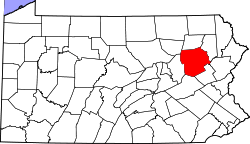 | |
| Boroughs |
| |
| Townships | ||
| CDPs | ||
| Unincorporated communities |
| |
| Footnotes | ‡This populated place also has portions in an adjacent county or counties | |