Franklin Township, Hendricks County, Indiana
| Franklin Township | |
|---|---|
| Township | |
|
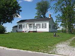
The McCormack-Bowman House, a historic site in the township's northeastern corner | |
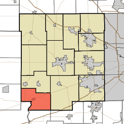 Location in Hendricks County | |
| Coordinates: 39°38′36″N 86°37′22″W / 39.64333°N 86.62278°WCoordinates: 39°38′36″N 86°37′22″W / 39.64333°N 86.62278°W | |
| Country | United States |
| State | Indiana |
| County | Hendricks |
| Government | |
| • Type | Indiana township |
| Area | |
| • Total | 26.48 sq mi (68.57 km2) |
| • Land | 26.43 sq mi (68.47 km2) |
| • Water | 0.04 sq mi (0.11 km2) 0.16% |
| Elevation | 787 ft (240 m) |
| Population (2010) | |
| • Total | 1,297 |
| • Density | 49.1/sq mi (18.9/km2) |
| GNIS feature ID | 0453304 |
Franklin Township is one of twelve townships in Hendricks County, Indiana, United States. As of the 2010 census, its population was 1,297.[1]
History
McCormack-Bowman House was added to the National Register of Historic Places in 1995.[2]
Geography
Franklin Township covers an area of 26.48 square miles (68.6 km2); of this, 0.04 square miles (0.10 km2) or 0.16 percent is water. The streams of Crittenden Creek and East Fork Mill Creek run through this township.
Cities and towns
Adjacent townships
- Clay Township (north)
- Liberty Township (east)
- Monroe Township, Morgan County (east)
- Adams Township, Morgan County (south)
- Jefferson Township, Putnam County (southwest)
- Marion Township, Putnam County (west)
Cemeteries
The township contains five cemeteries: Hebron Presbyterian, Pleasant Hill, Snoddy Family, Stilesville and Walnut Grove.
Major highways
Airports and landing strips
- Vaughn Airport
References
- "Franklin Township, Hendricks County, Indiana". Geographic Names Information System. United States Geological Survey. Retrieved 2009-09-24.
- United States Census Bureau cartographic boundary files
- ↑ United States Census Bureau American FactFinder
- ↑ National Park Service (2010-07-09). "National Register Information System". National Register of Historic Places. National Park Service.
External links
Municipalities and communities of Hendricks County, Indiana, United States | ||
|---|---|---|
| Towns | ||
| Townships | ||
| Unincorporated communities |
| |
| Footnotes | ‡This populated place also has portions in an adjacent county or counties | |
This article is issued from Wikipedia - version of the 4/13/2016. The text is available under the Creative Commons Attribution/Share Alike but additional terms may apply for the media files.