Friendship Village, Maryland
| Friendship Village, Maryland | |
|---|---|
| census-designated place | |
 | |
| Coordinates: 38°57′45″N 77°5′25″W / 38.96250°N 77.09028°WCoordinates: 38°57′45″N 77°5′25″W / 38.96250°N 77.09028°W | |
| Country |
|
| State |
|
| County |
|
| Area | |
| • Total | 0.055 sq mi (0.143 km2) |
| • Land | 0.055 sq mi (0.143 km2) |
| • Water | 0.0 sq mi (0.0 km2) |
| Elevation | 305 ft (93 m) |
| Population (2000) | |
| • Total | 4,512 |
| • Density | 81,992/sq mi (31,657/km2) |
| Time zone | Eastern (EST) (UTC-5) |
| • Summer (DST) | EDT (UTC-4) |
| FIPS code | 24-30837 |
| GNIS feature ID | 1852591 |
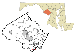
Friendship Village is an unincorporated area in Montgomery County, Maryland, United States. Inclusive within the Friendship Village CDP is the Village of Friendship Heights. (See also: Friendship Heights.) The population was 4,512 at the 2000 census.
Geography
As an unincorporated area, Friendship Village's boundaries are not officially defined. Friendship Village is, however, recognized by the United States Census Bureau as a census-designated place, and by the United States Geological Survey as a populated place located at 38°57′45″N 77°5′25″W / 38.96250°N 77.09028°W (38.962510, -77.090181).[1]
According to the United States Census Bureau, the place has a total area of 0.05503 square miles (0.1425 km2), all of it land.[2]
Demographics
As of the census[3] of 2000, there were 4,512 people, 2,995 households, and 1,003 families residing in the area. The population density was 81,992/sq mi (31,657/km²): this is the highest population density of any incorporated or census-designated place in the United States.[4] There were 3,189 housing units at an average density of 57,950/sq mi (20,521/km²).
The racial makeup of the area was 83.91% White, 4.52% African American, 0.11% Native American, 8.09% Asian, 0.02% Pacific Islander, 0.95% from other races, and 2.39% from two or more races. Hispanic or Latino of any race were 7.96% of the population.
There were 2,995 households out of which 6.1% had children under the age of 18 living with them, 28.4% were married couples living together, 3.9% had a female householder with no husband present, and 66.5% were non-families. 61.3% of all households were made up of individuals and 25.3% had someone living alone who was 65 years of age or older. The average household size was 1.51 and the average family size was 2.31.
In the area, the population was spread out with 5.9% under the age of 18, 4.8% from 18 to 24, 30.7% from 25 to 44, 26.1% from 45 to 64, and 32.4% who were 65 years of age or older. The median age was 51 years. For every 100 females there were 66.4 males. For every 100 females age 18 and over, there were 65.2 males.
The median income for a household in the area was $61,532, and the median income for a family was $80,497. Males had a median income of $70,500 versus $57,500 for females. The per capita income for the area was $53,689. About 4.6% of families and 5.2% of the population were below the poverty line, including none of those under age 18 and 6.7% of those age 65 or over.
Village of Friendship Heights
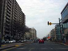
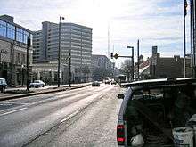
Although not an incorporated municipality, the Village of Friendship Heights was established as a Special Tax District in 1914. Its boundaries—Wisconsin Avenue, Willard Avenue, and Somerset Terrace[5]—enclose 34 acres (140,000 m²) and is almost entirely occupied by high-rise residential buildings. It has the highest population density of any census designated place or city in the United States. In fact, its density exceeds the borough of Manhattan.[6][7] The 2010 population of Friendship Village Heights was 4,698,[8] giving it a population density of 88,432 per square mile, versus Manhattan's approximate 70,000.
Large Residential Buildings:[9]
- 4620 North Park (condo)
- 4701 Willard Apartments (Formerly known as The Irene)
- The Carleton (condo)
- The Elizabeth (condo)
- Highland House & Highland House West (apartments)
- North Park (apartments)
- Somerset House 1, 2, & 3 (condominiums)
- The Willoughby of Chevy Chase Condominium
The village is governed by a seven-member village council;[10] each member is elected to a two-year term.
In 2000, the village gained national attention when it sought to ban smoking in all public spaces maintained by the local government. The ban, considered one of the strictest in the nation, went into effect December 12, 2000, but it was voided by a judge on March 2, 2001, who said the village did not have the authority to enact such a ban, as it is a special tax district and not an incorporated municipality.
The Village government operates a shuttle bus which circles the neighborhood, making stops at the major residential buildings, the Friendship Heights Village Center, nearby shopping centers, and the Friendship Heights stop of the Washington Metro.
From 1971 to 1974, Erlebacher's ladies specialty store was located in the Holiday Inn Plaza shopping mall at 5512 Wisconsin Avenue.
See also
References
- ↑ "US Gazetteer files: 2010, 2000, and 1990". United States Census Bureau. 2011-02-12. Retrieved 2011-04-23.
- ↑ "G001. GEOGRAPHIC IDENTIFIERS; Census 2000 Summary File 1 (SF 1) 100-Percent Data". U.S. Census Bureau. Retrieved 2009-01-28.
- ↑ "American FactFinder". United States Census Bureau. Retrieved 2008-01-31.
- ↑ List of United States cities by population density, separate Wikipedia entry with specific references from the US Census Bureau.
- ↑ "About the Community". Town of Friendship Village. Retrieved 2008-04-02.
- ↑ "State and County QuickFacts: New York (city), New York". United States Census Bureau. Retrieved July 30, 2014.
- ↑ "Population Density", Geographic Information Systems – GIS of Interest. Accessed June 30, 2009. "What I discovered is that out of the 3140 counties listed in the Census population data only 178 counties were calculated to have a population density over one person per acre. Not surprisingly, New York County (which contains Manhattan) had the highest population density with a calculated 104.218 persons per acre."
- ↑ "Friendship Heights Village CDP, Maryland - American Fact Finder". United States Census Bureau. Retrieved November 17, 2015.
- ↑ "The Friendship Heights Sector Plan" (PDF). Montgomery County Planning Department. Retrieved 2014-07-07.
- ↑ "The Council Report: 2007 Annual Report & Proposed Budget for Fiscal Year 2009" (PDF). Town of Friendship Village. Retrieved 2008-04-02.
External links
Municipalities and communities of Montgomery County, Maryland, United States | ||
|---|---|---|
| Cities | 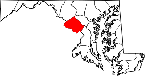 | |
| Towns | ||
| Villages & Special Tax Districts | ||
| CDPs |
| |
| Unincorporated communities | ||
| Footnotes | ‡This populated place also has portions in an adjacent county or counties | |