Colesville, Maryland
| Colesville, Maryland | |
|---|---|
| Census-designated place | |
 Location of Colesville, Maryland | |
| Coordinates: 39°4′47″N 77°0′12″W / 39.07972°N 77.00333°WCoordinates: 39°4′47″N 77°0′12″W / 39.07972°N 77.00333°W | |
| Country |
|
| State |
|
| County |
|
| Area | |
| • Total | 9.2 sq mi (23.9 km2) |
| • Land | 9.2 sq mi (23.9 km2) |
| • Water | 0.0 sq mi (0.0 km2) |
| Elevation | 436 ft (133 m) |
| Population (2000) | |
| • Total | 19,810 |
| • Density | 2,144.4/sq mi (828.0/km2) |
| Time zone | Eastern (EST) (UTC-5) |
| • Summer (DST) | EDT (UTC-4) |
| ZIP codes | 20904, 20905, 20914 |
| Area code(s) | 301, 240 |
| FIPS code | 24-18475 |
| GNIS feature ID | 0589998 |
Colesville is a census-designated place and an unincorporated area in Montgomery County, Maryland, in the United States.
Geography
As an unincorporated area, Colesville's boundaries are not officially defined. In fact, many residents consider the town to be one of the many neighborhoods of Silver Spring, Maryland. Colesville is recognized by the United States Postal Service as an acceptable city name in two northeastern Montgomery County ZIP codes, with Silver Spring being the preferred city name. It is also recognized by the United States Census Bureau as a census-designated place, and by the United States Geological Survey as a populated place located at 39°4′47″N 77°0′12″W / 39.07972°N 77.00333°W (39.079695, -77.003263).[1]
According to the United States Census Bureau, the place has a total area of 9.2 square miles (24 km2), all of it land.
Colesville's generally accepted boundaries extend between the Northwest and Paint Branches of the Anacostia River. Its northern and southern boundaries are not as well-defined, but are usually assumed to run from Springbrook High School in the south to Cloverly in the north.
History
The first land was purchased in Colesville from the Lords Baltimore in 1714, when Archibald Edmonston patented "Easy Purchase", a 900-acre (3.6 km2) tract that extended from Meadowood south to near present-day Route 29. In 1715, "Easy Purchase" was bought by James Beall, Sr., who that year also patented "Drumeldry", a 225-acre (0.91 km2) tract from the Northwest Branch across Notley Road to Shannon Drive. In 1718, his nephew William Beall patented "Wolf's Den", a 317-acre (1.28 km2) tract that straddled today's Bonifant Road and ran from Notley Road to Pebblestone Drive, and then southwest across the Northwest Branch.
However, none of these early landowners actually resided in Colesville. Robert Lazenby, thought to be the son of Henry Lazenby, High Sheriff of Anne Arundel County, purchased 217 acres (0.88 km2) of the southern part of "Wolfs Den" from William Beall in 1723, and became the first president farmer in Colesville.
In 1747, James Odell, grandson of James Beall Sr., was deeded 300 acres (1.2 km2) of a tract known as "Beal Christie" from his parents, and took to farming it. It was located east of today's New Hampshire Avenue near where it crosses Randolph Road.[2]
In the 1790s, Peter Kemp built a saw and grist mill on Paint Branch where it is crossed by today's Randolph Road. The mill was rebuilt twice, and what is seen today in Valley Mill Park is the 1879 mill built by Franklin Pilling, which ceased to operate by 1930.[3]
The earliest recorded use of the "Colesville" name was on January 25, 1806, when the General Assembly of Maryland changed the place of holding elections of the Fourth Election District of Montgomery County to "Edward Berry's, commonly called Coale's-Ville".[4] It is unknown where this name came from, but it may have come from the maiden name of Elizabeth (Coale) Snowden, wife of Richard Snowden who was the owner of "Snowden's Manor" in nearby Sandy Spring and began living there in 1728.[5] By 1824 the name was generally known as "Coalsville",[6] and was sometimes referred to as such even as late as 1906.[7]
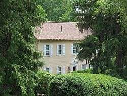
The oldest standing house in Colesville is "Milimar" at 410 Randolph Road, which is in the National Register of Historic Places and was built around 1790. It is also known as "The Old Lazanby Home",[8] but was probably built by Samuel and Mary Peach, who purchased the 164.5-acre (0.666 km2) tract it is on known as "Peaches Lot" from Evan Thomas shortly after he freed his slaves.[2]
The New York Times reported[9] that President Franklin Pierce purchased a farm of 600 acres (2.4 km2) in Colesville in 1855.
Joseph F. Burr started purchasing Colesville-area land in 1869. By 1872, he had amassed nearly 1,000 acres (4.0 km2) and lived in a beautiful mansion on the property known as Valley View. The mansion was located on the north side of today's Randolph Road, on the site of today's Holy Family Seminary. Burr was a friend of President Grover Cleveland, who visited Valley View frequently.[2]
An old house built in 1850 is still standing at 13910 Notley Road.[10] It was used as a school by a Miss Laxbenny in the late 1800s and was known as "Drumeldra".
In 1927, the Smithville Colored School was founded in Colesville. It was one of sixteen schools for African Americans constructed in the county with financial assistance from the Julius Rosenwald Fund. It was closed in 1952 when all Montgomery County schools for "colored" children were consolidated.
Colesville United Methodist Church is located in Colesville, Maryland.
The Holy Family Seminary, headquarters of the American Delegation of the catholic order of the Sons of the Holy Family, is also located in Colesville, since 1946.
Colesville hosts the Strawberry Festival every May. The festival is located at the corner of Hobbes Drive and New Hampshire Avenue. Vendors sell strawberries and ice cream, and volunteers organize carnival games for kids.
On February 6, 2010, Colesville had a record regional snowfall of 40.00 inches.
Demographics
As of the US census[11] of 2000, there were 19,810 people, 6,525 households, and 5,526 families residing in the area. The population density was 2,144.4 people per square mile (827.8/km²). There were 6,615 housing units at an average density of 716.1 per square mile (276.4/km²). The racial makeup of the area was 55.33% White, 22.25% African American, 0.23% Native American, 17.93% Asian, 0.02% Pacific Islander, 1.52% from other races, and 2.72% from two or more races. Hispanic or Latino of any race were 4.79% of the population.
There were 6,525 households out of which 37.1% had children under the age of 18 living with them, 73.1% were married couples living together, 9.0% had a female householder with no husband present, and 15.3% were non-families. 12.3% of all households were made up of individuals and 5.7% had someone living alone who was 65 years of age or older. The average household size was 3.02 and the average family size was 3.28.
In the area the population was spread out with 25.1% under the age of 18, 6.7% from 18 to 24, 23.0% from 25 to 44, 31.5% from 45 to 64, and 13.7% who were 65 years of age or older. The median age was 42 years. For every 100 females there were 94.7 males. For every 100 females age 18 and over, there were 90.7 males.
The median income for a household in the area was $91,696, and the median income for a family was $97,406. Males had a median income of $61,119 versus $46,169 for females. The per capita income for the area was $34,942. About 2.0% of families and 3.0% of the population were below the poverty line, including 3.8% of those under age 18 and 2.6% of those age 65 or over.
References
- ↑ "US Gazetteer files: 2010, 2000, and 1990". United States Census Bureau. 2011-02-12. Retrieved 2011-04-23.
- 1 2 3 Ned Bayley, "Colesville, Maryland: The Development of a Community, its People and its Natural Resources, Over a Period of Four Centuries", Heritage Books Inc., July 2003, ISBN 978-1-58549-004-2.
- ↑ Valley Mill Project
- ↑ Archives of Maryland, Volume 0607, Page 0061 - Session Laws, 1805
- ↑ The Founders of Anne Arundel and Howard Counties, Maryland, p. 361 https://books.google.com/books?id=vgINAAAAYAAJ&dq=%22the+founders+of+anne+arundel%22
- ↑ Archives of Maryland, Volume 0628, Page 0126 - Session Laws, 1823
- ↑ Archives of Maryland, Volume 0479, Page 0631 - Session Laws, 1906 Session
- ↑ Milimar - Archiplanet
- ↑ "The Future Home of President Fierce," New York Times, September 12, 1855
- ↑ results
- ↑ "American FactFinder". United States Census Bureau. Archived from the original on 2013-09-11. Retrieved 2008-01-31.
External links
 Geographic data related to Colesville, Maryland at OpenStreetMap
Municipalities and communities of Montgomery County, Maryland, United States | ||
|---|---|---|
| Cities | 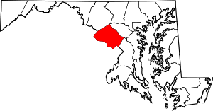 | |
| Towns | ||
| Villages & Special Tax Districts | ||
| CDPs |
| |
| Unincorporated communities | ||
| Footnotes | ‡This populated place also has portions in an adjacent county or counties | |