Montgomery Village, Maryland
| Montgomery Village, Maryland | |||||
|---|---|---|---|---|---|
| Census-designated place | |||||
| Montgomery Village Foundation | |||||
|
The Saint John Neumann Church in August 2013 | |||||
| |||||
| Nickname(s): "MVF"[1] | |||||
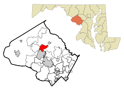 Location of Montgomery Village in Montgomery County, Maryland | |||||
| Coordinates: 39°10′35″N 77°11′34″W / 39.17639°N 77.19278°WCoordinates: 39°10′35″N 77°11′34″W / 39.17639°N 77.19278°W | |||||
| Country |
| ||||
| State |
| ||||
| County |
| ||||
| Created | 1962 | ||||
| Foundation incorporated | 1966 | ||||
| Government | |||||
| • Type | Foundation | ||||
| • Executive Vice President | David B. Humpton[2][3][4] | ||||
| Area[5] | |||||
| • Land | 3.974 sq mi (10.29 km2) | ||||
| • Water | 0.081 sq mi (0.209 km2) | ||||
| Elevation | 371 ft (113 m) | ||||
| Population (2010)[5] | |||||
| • Total | 32,032 | ||||
| • Density | 8,018.0/sq mi (3,096/km2) | ||||
| Time zone | Eastern (EST) (UTC-5) | ||||
| • Summer (DST) | EDT (UTC-4) | ||||
| ZIP codes | 20877, 20879, 20886 | ||||
| Area code(s) | 301, 240 | ||||
| FIPS code | 24-53325 | ||||
| GNIS feature ID | 1712797 | ||||
| Website |
www | ||||
.JPG)

Montgomery Village is a census-designated place (CDP) in Montgomery County, Maryland, United States, and a northern suburb of Washington, D.C.. It is a large, planned suburban community, developed in the late 1960s and 1970s just outside Gaithersburg city limits. Montgomery Village's population was 32,032 at the time of the 2010 U.S. Census,[5] and it is a part of the Washingtonian metropolitan area.
History
1960s
Montgomery Village was created in 1962 by Kettler Brothers, Inc. The vision for a planned community in Gaithersburg is credited to architect Charles Kettler, who incorporated Kettler Brothers with his brothers Milton and Clarence in 1952. The first land purchase was the Walker Farm in 1962. Subsequent purchases were the Thomas Farm, The Mills Farm, The French Farm, The Patton Farm, The Fulks Farm, The Wilson Farm, and The James Walter Deppa property. The Walker Farm was the largest of all the properties the Kettlers bought. It was 412 acres (1.67 km2) and now is Walkers Choice, Cider Mill, Horizon Run, Christopher Court, Dockside, Nathan’s Hill, Millrace, the Montgomery Village Library, Montgomery Village Day-Care Center, the Off-Price Centers, Bayberry, the Verandahs, Grover’s Forge, Lake Whetstone, South Valley Park, and part of Lakeforest Mall.[6]
On February 28, 1966, the Kettler brothers broke ground for the first house in Montgomery Village. The first model homes were opened in Lakeside of Whetstone in August 1967. In September, more opened in the Clusters of Stedwick. The Montgomery Village Golf Club also opened in September of that year. The first residents of Montgomery Village moved in on September 25, 1967, in Goshenside. They were the Bartik family. Also on the same day, the Crosby family moved into a home on Whetstone Drive.
The Montgomery Village Foundation was incorporated in 1966. In 1968, the Whetstone Community Center opened, as did Whetstone Elementary and Montgomery Village Middle schools.
1970s
In 1970, The Village Mall opened, which is now the Village Shopping Center on Montgomery Village Avenue. Then in 1971, a Holiday Inn was opened. In 1973, bus service to Washington, D.C., began.[7]
1990s
In 1998, Montgomery Village began using its own ZIP code, 20886.[8]
2010s
The Montgomery Village Golf Club closed November 30, 2014.[9]
Geography
Although Montgomery Village is an unincorporated area, its boundaries are defined according to Montgomery County zoning rules and by its own unique ZIP code. Montgomery Village can use Gaithersburg addresses even though the village is outside city limits. Montgomery Village is recognized by the U.S. Census Bureau as a census-designated place, and by the U.S. Geological Survey as a populated place located at 39°10′35″N 77°11′34″W / 39.17639°N 77.19278°W (39.176469, -77.192654).[10]
According to the U.S. Census Bureau,[11] the place has a total area of 4.055 square miles (10.50 km2), of which, 3.974 square miles (10.29 km2) of it is land and 0.081 square miles (0.21 km2) of it (1.99%) is water.
Education
Montgomery Village is served by Montgomery County Public Schools.[12]
Elementary schools
- South Lake Elementary School
- Stedwick Elementary School
- Watkins Mill Elementary School
- Whetstone Elementary School
Middle schools
- Montgomery Village Middle School
High schools
Demographics
| Historical population | |||
|---|---|---|---|
| Census | Pop. | %± | |
| 1980 | 18,725 | — | |
| 1990 | 32,315 | 72.6% | |
| 2000 | 38,051 | 17.8% | |
| 2010 | 32,032 | −15.8% | |
| source:[5][13] | |||
2010 U.S. Census
As of the 2010 U.S. Census, there were 32,032 people and 11,751 households residing in the area.[5] The population density was 8,018 people per square mile (3,096/km2).[5] There were 12,471 housing units.[5]
The median income for a household in the area was $76,526.[5] The per capita income for the area was $35,389.[5]
2000 U.S. Census
As of the 2000 U.S. Census,[14] there were 38,051 people, 14,142 households, and 9,729 families residing in the area. The population density was 5,875.1 people per square mile (2,267.2/km²). There were 14,548 housing units at an average density of 2,246.2 per square mile (866.8/km²). The ethnic makeup of the area was 38.1% White, 23.2% African American, 0.2% Native American, 10.7% Asian, 0.0% Pacific Islander, 0.5% from other races, and 2.9% from two or more races. Hispanic or Latino of any race were 24.0% of the population.
There were 14,142 households out of which 36.8% had children under the age of 18 living with them, 52.5% were married couples living together, 12.6% had a female householder with no husband present, and 31.2% were non-families. 24.0% of all households were made up of individuals and 4.9% had someone living alone who was 65 years of age or older. The average household size was 2.68 and the average family size was 3.21.
In the area, the population was spread out with 26.6% under the age of 18, 7.5% from 18 to 24, 35.4% from 25 to 44, 23.5% from 45 to 64, and 7.0% who were 65 years of age or older. The median age was 34 years. For every 100 females there were 90.9 males. For every 100 females age 21 and over, there were 87.7 males.
The median income for a household in the area was $66,828, and the median income for a family was $74,920 (these figures had risen to $89,601 and $97,837 respectively as of a 2008 estimate[15]). Males had a median income of $50,046 versus $38,665 for females. The per capita income for the area was $29,620. About 3.9% of families and 7.1% of the population were below the poverty line, including 6.6% of those under age 18 and 3.4% of those age 65 or over.
References
- ↑ http://www.mvf.org/
- ↑ "Office of the EVP". Maryland. 2016. Retrieved October 13, 2016.
David B. Humpton has served as executive vice president since November 2007.
- ↑ "EVP Biography". Montgomery Village Foundation. AssociationVoice. Archived from the original on March 4, 2012. Retrieved March 4, 2012.
David B. Humpton became the executive vice president of the Montgomery Village Foundation on November 1, 2007. As chief operating officer under the direction of the president of the Board of Directors, Humpton leads and directs the daily operations of the Foundation.
- ↑ "David B. Humpton". Montgomery Village Foundation, Inc. Archived from the original on May 12, 2016. Retrieved May 12, 2016.
- 1 2 3 4 5 6 7 8 9 United States Census Bureau (February 5, 2015). "Montgomery Village CDP, Maryland". State and County QuickFacts. United States of America: United States Census Bureau. Retrieved February 11, 2015.
- ↑ "Village History | Montgomery Village". montgomeryvillage.com. Retrieved 2016-11-28.
- ↑ Montgomery Village Foundation - Village History
- ↑ Bates, Jennifer (December 30, 1998). "Top Montgomery Village news stories for 1998". The Gazette. 9030 Comprint Court, Gaithersburg, Maryland: Post-Newsweek Media, Inc. Archived from the original on March 7, 2012. Retrieved March 7, 2012.
- ↑ O'Connell, Jonathan (April 10, 2014). "In Montgomery Village, turning a golf course into a neighborhood". The Washington Post. Washington, D.C. Retrieved March 10, 2016.
- ↑ "US Gazetteer files: 2010, 2000, and 1990". United States Census Bureau. 2011-02-12. Retrieved 2011-04-23.
- ↑ Geography, US Census Bureau. "2016 U.S. Gazetteer Files Record Layouts". www.census.gov. Retrieved 2016-11-28.
- ↑ "Montgomery County Public Schools, Rockville, MD". gis.mcpsmd.org. Retrieved 2016-11-28.
- ↑ "CENSUS OF POPULATION AND HOUSING (1790-2000)". United States Census Bureau. Retrieved July 17, 2010.
- ↑ "American FactFinder". United States Census Bureau. Retrieved 2008-01-31.
- ↑ 2006-2008 American Community Survey 3-Year Estimates
External links
| Wikimedia Commons has media related to Montgomery Village, Maryland. |
- Official website
- Montgomery Village Foundation at the Wayback Machine (archived December 22, 1997)
 |
Clarksburg | Damascus | Laytonsville | |
| Germantown | |
Olney | ||
| ||||
| | ||||
| Darnestown | Gaithersburg | Redland |
Municipalities and communities of Montgomery County, Maryland, United States | ||
|---|---|---|
| Cities | 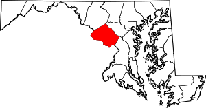 | |
| Towns | ||
| Villages & Special Tax Districts | ||
| CDPs |
| |
| Unincorporated communities | ||
| Footnotes | ‡This populated place also has portions in an adjacent county or counties | |