Friesland, Minnesota
| Friesland, Minnesota | |
|---|---|
| Unincorporated community | |
 Friesland, Minnesota  Friesland, Minnesota Location of the community of Friesland | |
| Coordinates: 46°05′08″N 92°55′47″W / 46.08556°N 92.92972°WCoordinates: 46°05′08″N 92°55′47″W / 46.08556°N 92.92972°W | |
| Country | United States |
| State | Minnesota |
| County | Pine |
| Township | Dell Grove Township |
| Elevation | 1,142 ft (348 m) |
| Population | |
| • Total | 40 |
| Time zone | Central (CST) (UTC-6) |
| • Summer (DST) | CDT (UTC-5) |
| ZIP code | 55037 |
| Area code(s) | 320 |
| GNIS feature ID | 643962[1] |
Friesland is an unincorporated community in Dell Grove Township, Pine County, Minnesota, United States.
The community is located between Hinckley and Sandstone; near the intersection of Pine County 61, Pine County 26, and the former Northern Pacific Railway (now the Willard Munger State Trail).
History
Located in the southeast corner of Dell Grove Township, Friesland is named after the northern province of the Netherlands.[2] The community was originally called South Junction, as it was at the juncture of the Great Northern and Northern Pacific railroads. It operated a post office from 1896 to 1917.[3]
References
- ↑ "Friesland, Minnesota". Geographic Names Information System. United States Geological Survey.
- ↑ Upham, Warren (1920). Minnesota Geographic Names: Their Origin and Historic Significance. Minnesota Historical Society. p. 411.
- ↑ "Pine County". Jim Forte Postal History. Retrieved 30 July 2015.
- Official State of Minnesota Highway Map – 2011/2012 edition
Municipalities and communities of Pine County, Minnesota, United States | ||
|---|---|---|
| Cities | 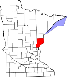 | |
| Townships | ||
| Unincorporated communities | ||
| Ghost towns | ||
| Indian reservation | ||
This article is issued from Wikipedia - version of the 10/24/2016. The text is available under the Creative Commons Attribution/Share Alike but additional terms may apply for the media files.