Gürpınar (District), Van
| Gürpınar | |
|---|---|
 Gürpınar | |
| Coordinates: 38°19′37″N 43°24′48″E / 38.32694°N 43.41333°ECoordinates: 38°19′37″N 43°24′48″E / 38.32694°N 43.41333°E | |
| Country | Turkey |
| Province | Van |
| Government | |
| • Mayor | Zeki Yıldız (BDP) |
| • Kaymakam | Nurullah Kaya |
| Area[1] | |
| • District | 4,130.30 km2 (1,594.72 sq mi) |
| Population (2012)[2] | |
| • Urban | 5,780 |
| • District | 39,238 |
| • District density | 9.5/km2 (25/sq mi) |
| Post code | 65900 |
| Website |
www |
Gürpınar (Kurdish: Payîzava) is a district of Van Province and 20 km (12 mi) south of the provincial capital Van. With an area of 4,700 km2, Gürpınar is the largest district of Turkey. It has 72 villages and several places of historical interest. Much of the residents of this area speak Kurmanci, the most commonly spoken dialect of the Kurdish language.
Name
The area's old name and Armenian name was "Hayots-tzor" (Armenian: Հայոց Ձոր, meaning Valley of the Armenians). Its Kurdish name is "Payizava".
History
In Armenian mythology, Hayots Dzor is the valley where the Armenian progenitor Hayk defeated the army of the invading Assyrian king Bel and constructed a fortress (Haykaberd) nearby.
In the Middle Ages, the area was the location of the Armenian kingdom of Vaspurakan, ruled by the Artsruni House of Armenian kings.
Historical places
- Hoşap Castle
- Haykaberd Urartian castle
- Surp Marinos Monastery
- Zernek castle near Hamurkesen, Van
- Dar Mariam Church
- Put cave and cave pics
- Tirishim plateau, rock pictures park
- Menua Canal
References
- ↑ "Area of regions (including lakes), km²". Regional Statistics Database. Turkish Statistical Institute. 2002. Retrieved 2013-03-05.
- ↑ "Population of province/district centers and towns/villages by districts - 2012". Address Based Population Registration System (ABPRS) Database. Turkish Statistical Institute. Retrieved 2013-02-27.
External links
- www.gurpinar.gov.tr Gurpinar Government - Gurpinar
- www.van-gurpinar.bel.tr Gurpinar Municipality- Gurpinar
Gürpınar (District), Van in Van Province of Turkey | |||||||||||||||||||||||||||||||||||||||||||||||||||
|---|---|---|---|---|---|---|---|---|---|---|---|---|---|---|---|---|---|---|---|---|---|---|---|---|---|---|---|---|---|---|---|---|---|---|---|---|---|---|---|---|---|---|---|---|---|---|---|---|---|---|---|
| Districts | 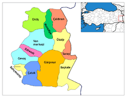 | ||||||||||||||||||||||||||||||||||||||||||||||||||
|
Metropolitan municipalities are bolded. | |||||||||||||||||||||||||||||||||||||||||||||||||||