Başkale
| Başkale | |
|---|---|
 Başkale | |
| Coordinates: 38°02′51″N 44°00′54″E / 38.04750°N 44.01500°ECoordinates: 38°02′51″N 44°00′54″E / 38.04750°N 44.01500°E | |
| Country |
|
| Province | Van |
| Government | |
| • Mayor | İhsan Güler (BDP) |
| • Kaymakam | Murat Büyükköse |
| Area[1] | |
| • District | 2,730.89 km2 (1,054.40 sq mi) |
| Population (2012)[2] | |
| • Urban | 12,784 |
| • District | 62,550 |
| • District density | 23/km2 (59/sq mi) |
| Post code | 65600 |
| Website |
www |
Başkale (Armenian: Ադամակերտ Adamakert; Kurdish: Elbak) is a town and district located in south-eastern Turkey in Van Province. There is one municipality in the Başkale district, the town centre, which was established 1937. The neighbourhoods of the town of Başkale are: Tepebaşı, Yeni mahalle, Camii-Kebir, Samandöken, Cevkan, Kale, Hafiziye, Tarım and Yakınyol.
Etymology
Urartians named the town Adamma (c. 900-300BC). The Armenians called it Adamakert (c. 100BC-18AD), meaning "Adam's city". Since the late 19th century AD Turks have called it Başkale (rendered in Anglicised form as Bashkala or Pashgala), meaning "head fortress", 'head' referring to its location at the head of a valley.
Geography
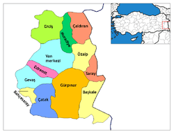
Başkale is situated 20 km (12 mi) west of the Turkey-Iran border. 138 km (86 mi) of the national border is on the east and north-east of the Başkale district. Başkale shares district borders with Yüksekova district of Hakkari Province to the south, Saray and Özalp districts of Van Province to the north, and Gürpınar district of Van Province to the west.
Başkale is situated 2460 metres above sea level, in the valley of the Great Zab River (Zapsuyu), and the town stands on the eastern slope of the south eastern Taurus Mountains. The majority of the 2,599 km2 (1,003 sq mi) Başkale district is mountainous. The agricultural portion is only 355 km2 (137 sq mi), approximately 14% of the total area. Başkale is enclosed by Mount (Yiğit)/Haravil (3468 m) in the east, Mount Başkale/İspiriz (3668 m) in the west, and Mount Gökdağ (3604 m) in the south-east. The mountains of Mor, Haravil, Mengene and Çekvan are in the district of Başkale. Other geographical features in Başkale include the Karasu river, and the plateaus of Nebirnav, Kevçikan, Hanasor, Çekvan, Aşkitan (Ülya), Perihan, Meydan, Harinan, Terazın, Sülav, Medgezeren, Pistekan, Herevil-Şirez, Derevan, Derik, Bağarük, Düava and Mengen.
History
Başkale was founded by Urartians as the town of Adamma. Since the 2nd century BC it was known in Armenian language as Adamakert (Ադամակերտ) and was the main fortress of the Medz Aghbak district of the Armenian kingdom. Since 385 AD control of the area alternated between Parthia and the Roman Empire. In the 3rd century AD the Sassanid (Persian) Empire took control of district from the Roman Empire.
After the division of the Roman Empire, the Byzantine Empire took control in the 6th century. In 645AD Arabs took control of the Başkale area. In the period of the Arsacid and Bagratuni dynasties' rule, Adamakert was taken back by the Armenian kingdom from the Persian and Arabians. During the Arsacid era, Adamakert was a part of Armenia's Aghbak district and was a possession of Vaspurakan's Artsruni dynasty. The 10th century chronicler, Tovmas Artzruni, wrote that the dynasty had originated in this region, and mentions the city-fortress of Adamakert as the residence of the dynasty (believed to be the site of present-day Başkale).[3]
After the Battle of Malazgirt in 1071, control passed to Seljuk Empire. After 1100, Ahlatshah beylik (Sökmenoğulları) controlled the area. After a short period of Ayyubid control and the Mongol attack of 1245, the region was controlled by Anatolian Seljuks, Ilkhanate, and Timur. After the overthrow of Timur in 1386 by Kara Koyunlu federation of Turkoman tribes, the Safavids took control at the beginning of the 16th century. When the Yavuz Sultan Selim defeated the Safavids in the Battle of Çaldıran, Van and surrounding area was included in Ottoman Empire, but control returned to the Safavids several times after the Battle of Çaldıran. In 1548, during the period of Kanuni Sultan Süleyman, the Ottoman Empire finally took full control of the area.
In 1829, the German orientalist Friedrich Eduard Schulz was murdered near Başkale, along with four servants. Schultz had been traveling in the area since 1827, recording evidence of Urartian culture. Başkale became the capital town of Elbak kaza of Hakkari sanjak in the Ottoman vilayet (province) of Van.[4] After the constitution of the republic of Turkey in 1923, its name was changed to Başkale and it became a part of Van Province.
One of many events in the string of tensions prior to World War I was a massacre of approximately fifty Gawarnai Assyrians by Muslims on 30 October 1914 at Başkale in the local government centre.[5] Armenians of Başkale were later deported and massacred by Turks and Kurds during the Armenian genocide (approximately 1915-1918).[6]
Demography and population
In 2000, the population of the town of Başkale was recorded at 14,114, and the population of the district was recorded at 55,563.[7] Approximately 80% of the district speaks a Kurdish dialect.[8] The population structure shows a tribal construction, with the breakdown of ethnic groups given as follows:[8]
| Demography | |
|---|---|
| Tribe | Percentage |
| Ertuşi | 40% |
| Merziki | 30% |
| Botan | 15% |
| Pinyaniş | 15% |
| Population | |||
|---|---|---|---|
| Years | Town | Villages | Total |
| 2000 | 14,114 | 41,449 | 55,563 |
| 1997 | 15,070 | 34,606 | 49,676 |
| 1990 | 16,418 | 39,179 | 55,597 |
| 1985 | 10,615 | ||
| 1980 | 9,770 | ||
| 1975 | 8,558 | ||
| 1970 | 6,018 | ||
| 1965 | 4,007 | ||
| 1960 | 2,383 | ||
| Villages of Başkale district, Van Province | | |
|---|---|---|
|
Açıkağıl | Akçalı | Albayrak | Aşağıküme | Aşalan | Atlılar | Aydemir | Azıklı | Barış | Başkale | Belencik | Beşocak | Bilgeç | Böğrüpek | Bölekli | Büklümdere | Çakırdoğan | Çaldıran | Dereiçi | Deringeçit | Ekecek | Erek | Erkonağı | Esenyamaç | Eşmepınar | Gedikbaşı | Gelenler | Güleçler | Güroluk | Güvendik | Ilıcak | Işıklı | Kaşkol | Kavurgalı | Keçilioba | Kızılca | Kocaköy | Koçdağı | Konuksayar | Kovalıpınar | Köprüağzı | Mahmutabat | Oğulveren | Ortayazı | Ortayol | Ömerdağı | Öncüler | Örencik | Örenkale | Özpınar | Saçan | Sallıdere | Savaşköy | Tahılköy | Tınazlı | Uğurlu | Yanal | Yavuzlar | Yolmaçayır | Yukarıdallı | Yukarıdarıca | Yukarıdikmen | Yurttepe | ||
Economy
Stock-breeding is dominant in the economy of Başkale district. Smuggling also is a widespread activity in border areas. There is no industrial activities except small workshops. There was a Marble production plant at Koçdağı village, but in 2001 was closed after some test production. Distribution of the population according to their economical activity;
- Stock-breeding; 80%
- Agriculture; 10%
- in different crafts; 8%
- trade; 2%
Agriculture
| Agricultural production | ||
|---|---|---|
| Product | Area (Ha) | Production (ton) |
| Wheat | 9,400 | 11,280 |
| Barley | 105 | 126 |
| Trefoil | 6,400 | 27 |
Stock-breeding
| Stock-breeding (1999)[9] | |
|---|---|
| Animal | Stock |
| Cattle | 29,313 |
| Sheep | 347,734 |
| Goat | 6,760 |
| Horse | 417 |
| Mule | 417 |
| Donkey | 417 |
| Hen | 11,600 |
| Turkey | 4,816 |
| Duck | 1,820 |
| Goose | 1,914 |
Culture
Media
There is one local radio station Pınar FM in Başkale.
Education
In Başkale district; ratio of educated people to total population is; 65% (November 2006).[10] Due to the demographic and traditional conditions, in the past,; majority of women and girls are not sent to schools. Educated people level among women is dramatically low.
In Başkale district;(November 2006)[10]
- total number of teachers ; 402
- Total number of girls in schools; 5,384
- Total number of boys in schools; 7,437
- Total number of students in village schools; 8,424
- Total number of students in town schools; 4,404
- Number of total students; 12,828
Sport
Başkale has a football team named as Başkale Spor in amateur league. Vali Abdülkadir SARI Football Stadium was opened in 1999 which has 1,500 seats. Başkale has also a gymnasium also finished at 1999.
Cuisine
Otlu peynir (a kind of cheese which include natural vegetables which differs with region) is a well known product of Başkale. Otlu peynir of Başkale includes these local natural vegetables; Devin, Mendi, Spi pancar, Pinger, Çatır, Nane, Handekuk, Spilinge, Kaşım, Kurat, Sirik, Gunbizin, Sılkuke, Sinameki, Mendi, Sirmo.
Başkale has many local varieties like as; Ayranaşı, Pancarlı Pilav, Keledoş, Keşkeş, Roasted Pancar, Pokin soup, Grara aki soup, Şoğra, Şeleke, Vireke, Tahinik
Tourism
Başkale is best known historically for being an Armenian pilgrimage center to Saint Bartholomew Monastery. It is also known for the military fortress of Adamakert. The now-ruined fortress was once occupied by a Kurdish bey (chieftain) and lies a short distance uphill from the township. The fortress is a good example of Urartian architecture.
Historical places
- Albayrak church (hy)
- Yanal church
- Erek church
- Örenkale(Başkal) castle
- Örenkale(Başkal) Seljuk medrese and dome
- Başkale castle
- Saint Bartholomew Monastery, a 13th-century Armenian monastery (mostly destroyed by the Turkish army using explosives in the 1960s)Template:Proof needed
- Soradir Armenian church
- Castle Mosque
- Hüsrev Paşa Medrese
Natural places
- Yavuzlar village fairy chimneys (locally called as "Vanadocia" referring to Cappadocia)
- Çamlık (kolegom) hot springs and picnic area
- Akçalı village limestone and travertine formation like as Pamukkale
Entombed saints
- Dereiçi village; Adil Kabul
- Köprüağzı village; Hejde Kev
- Esenyamaç village ; Kepenereş and Şah Şıh
- Öncüler village; Kelasinci Hevat
- Yavuzlar village; Mollahıdır Friendi
- Zap basında; Mehmet Çavuş yatırı
- Başkale ; Seyyid İsmail Hokan yatırı
- Güroluk village ; Şah İsmail Kutbeddinin and Şeyh İsmail Hakkari
- Çaldıran village; Şeyh Sucu
- Öncüler village ; Uzun Şehid
- Ilıcak village ; Pir
- Örencik village; Arafat Arabi
Facilities
Health services
There is one hospital and 5 clinics at Başkale district, with a total; 21 doctors and 36 health officers(midwife, nurse, health technician) in charge of health service in district.
- Başkale Hospital; in Başkale town
- Başkale center clinic; in Başkale town
- Albayrak village clinic; is in Albayrak village
- Çaldıran village clinic;is in Çaldıran village
- Eşmepınar village clinic; in Eşmepınar village
Accommodation
There are two hotels in Başkale.
References
- ↑ "Area of regions (including lakes), km²". Regional Statistics Database. Turkish Statistical Institute. 2002. Retrieved 2013-03-05.
- ↑ "Population of province/district centers and towns/villages by districts - 2012". Address Based Population Registration System (ABPRS) Database. Turkish Statistical Institute. Retrieved 2013-02-27.
- ↑ Fratadocchi, T. B., "The Church of Etchmiadzin at Soradir", Rome 1971.
- ↑ Kamusü’l Alam
- ↑ "A Brief History of the Assyrians in Iraq since 1900". Zinda Magazine.
- ↑ "Baskle". Triposo.com. Archived from the original on 7 April 2014. Retrieved 1 April 2014.
- ↑ 2000 census, Turkey
- 1 2 "Başkale District Government Office" (in Turkish). Archived from the original on 27 May 2007. Retrieved 2007-06-12.
- ↑ http://www.baskale.gov.tr District government office
- 1 2 http://baskale.meb.gov.tr/ Başkale National Education Directorate
Further reading
 Maunsell, Francis Richard (1911). "Bashkala". In Chisholm, Hugh. Encyclopædia Britannica. 3 (11th ed.). Cambridge University Press. pp. 465–466.
- "www.Baskale.gov.tr" (in Turkish).
- "Audio slideshow on the town of Baskale, documenting the local election campaign in 2009. Basque captions" (in Basque).