Gascoyne, North Dakota
| Gascoyne, North Dakota | |
|---|---|
| City | |
|
Gascoyne | |
 Location of Gascoyne, North Dakota | |
| Coordinates: 46°7′6″N 103°4′52″W / 46.11833°N 103.08111°WCoordinates: 46°7′6″N 103°4′52″W / 46.11833°N 103.08111°W | |
| Country | United States |
| State | North Dakota |
| County | Bowman |
| Founded | 1907 |
| Area[1] | |
| • Total | 1.00 sq mi (2.59 km2) |
| • Land | 1.00 sq mi (2.59 km2) |
| • Water | 0 sq mi (0 km2) |
| Elevation | 2,762 ft (842 m) |
| Population (2010)[2] | |
| • Total | 16 |
| • Estimate (2014)[3] | 16 |
| • Density | 16.0/sq mi (6.2/km2) |
| Time zone | Mountain (MST) (UTC-7) |
| • Summer (DST) | MDT (UTC-6) |
| ZIP code | 58653 |
| Area code(s) | 701 |
| FIPS code | 38-29540 |
| GNIS feature ID | 1029089[4] |
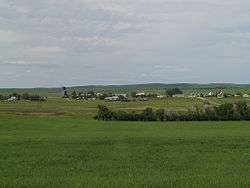
Gascoyne is a city in Bowman County, North Dakota, United States. The population was 16 at the 2010 census.[5]
History
The city was founded in 1907 and known originally as Fischbein before the name was changed to Gascoyne on March 25, 1908. The new name came from a construction foreman on the Milwaukee Road transcontinental rail line that was built through the city, though an alternate explanation suggests that the name refers to the large deposits of natural gas found in the area.[6]
Reserves of lignite coal are also found in the area, and Gascoyne was the site of a coal mine for much of the 20th century. The most active period for the mine occurred between 1975 and 1995, when about 2.5 million tons of lignite were produced per year, primarily for the Big Stone Power Plant near Big Stone City, South Dakota. The mine began ceasing production in 1995, and was shut down completely in 1997.[7] In 2001, Westmoreland Coal Company purchased the mine with an intent to resume mining and construct a 500 megawatt power plant on site. These plans were later suspended in 2008 due to environmental concerns.[8]
Geography
Gascoyne is located at 46°7′6″N 103°4′52″W / 46.11833°N 103.08111°W (46.118380, -103.081202).[9]
According to the United States Census Bureau, the city has a total area of 1.00 square mile (2.59 km2), all of it land.[1]
Demographics
| Historical population | |||
|---|---|---|---|
| Census | Pop. | %± | |
| 1920 | 60 | — | |
| 1930 | 97 | 61.7% | |
| 1940 | 48 | −50.5% | |
| 1950 | 76 | 58.3% | |
| 1960 | 50 | −34.2% | |
| 1970 | 34 | −32.0% | |
| 1980 | 23 | −32.4% | |
| 1990 | 22 | −4.3% | |
| 2000 | 23 | 4.5% | |
| 2010 | 16 | −30.4% | |
| Est. 2015 | 16 | [10] | 0.0% |
| U.S. Decennial Census[11] 2014 Estimate[3] | |||
2010 census
As of the census[2] of 2010, there were 16 people, 9 households, and 5 families residing in the city. The population density was 16.0 inhabitants per square mile (6.2/km2). There were 10 housing units at an average density of 10.0 per square mile (3.9/km2). The racial makeup of the city was 100.0% White.
There were 9 households of which 11.1% had children under the age of 18 living with them, 55.6% were married couples living together, and 44.4% were non-families. 44.4% of all households were made up of individuals and 11.1% had someone living alone who was 65 years of age or older. The average household size was 1.78 and the average family size was 2.40.
The median age in the city was 63.5 years. 12.5% of residents were under the age of 18; 0.0% were between the ages of 18 and 24; 25.1% were from 25 to 44; 18.8% were from 45 to 64; and 43.8% were 65 years of age or older. The gender makeup of the city was 62.5% male and 37.5% female.
2000 census
As of the census of 2000, there were 23 people, 9 households, and 8 families residing in the city. The population density was 23.3 people per square mile (9.0/km²). There were 15 housing units at an average density of 15.2 per square mile (5.8/km²). The racial makeup of the city was 100.00% White.
There were 9 households out of which 22.2% had children under the age of 18 living with them, 66.7% were married couples living together, 11.1% had a female householder with no husband present, and 11.1% were non-families. No households were made up of individuals and none had someone living alone who was 65 years of age or older. The average household size was 2.56 and the average family size was 2.50.
In the city the population was spread out with 30.4% under the age of 18, 8.7% from 25 to 44, 26.1% from 45 to 64, and 34.8% who were 65 years of age or older. The median age was 60 years. For every 100 females there were 130.0 males. For every 100 females age 18 and over, there were 128.6 males.
The median income for a household in the city was $23,750, and the median income for a family was $23,750. Males had a median income of $27,500 versus $13,750 for females. The per capita income for the city was $10,206. There are 18.2% of families living below the poverty line and 30.3% of the population, including 50.0% of under eighteens and none of those over 64.
References
- 1 2 "US Gazetteer files 2010". United States Census Bureau. Retrieved 2012-06-14.
- 1 2 "American FactFinder". United States Census Bureau. Retrieved 2012-06-14.
- 1 2 "Population Estimates". United States Census Bureau. Retrieved July 9, 2015.
- ↑ "US Board on Geographic Names". United States Geological Survey. 2007-10-25. Retrieved 2008-01-31.
- ↑ "2010 Census Redistricting Data (Public Law 94-171) Summary File". American FactFinder. United States Census Bureau. Retrieved 2 May 2011.
- ↑ Wick, Douglas A. "Gascoyne (Bowman County)". North Dakota Place Names. Retrieved 7 May 2011.
- ↑ Leistritz, F. Larry; Root, Kenneth A. (August 1999). "Rural Community Response to Closure/Downsizing of a Major Employer" (PDF). Agricultural Economics Report (422): 7–8.
- ↑ Wetzel, Dale (May 20, 2008). "Coal company suspends efforts to build N.D. power plant". Bismarck Tribune. Retrieved 7 May 2011.
- ↑ "US Gazetteer files: 2010, 2000, and 1990". United States Census Bureau. 2011-02-12. Retrieved 2011-04-23.
- ↑ "Annual Estimates of the Resident Population for Incorporated Places: April 1, 2010 to July 1, 2015". Retrieved July 2, 2016.
- ↑ United States Census Bureau. "Census of Population and Housing". Retrieved June 16, 2014.
External links
Municipalities and communities of Bowman County, North Dakota, United States | ||
|---|---|---|
| Cities | 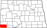 | |
| Townships | ||
| Unorganized territories | ||
| Unincorporated communities |
| |