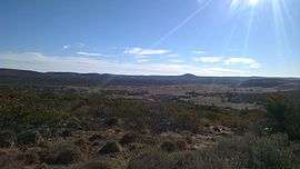
Gawler Ranges, South Australia
| Gawler Ranges South Australia | |||||||||||||
|---|---|---|---|---|---|---|---|---|---|---|---|---|---|
 | |||||||||||||
 Gawler Ranges | |||||||||||||
| Coordinates | 32°32′S 135°20′E / 32.54°S 135.33°ECoordinates: 32°32′S 135°20′E / 32.54°S 135.33°E | ||||||||||||
| Established | 2013[1] | ||||||||||||
| Postcode(s) | 5655[1] | ||||||||||||
| Time zone | ACST (UTC+9:30) | ||||||||||||
| • Summer (DST) | ACST (UTC+10:30) | ||||||||||||
| Location |
| ||||||||||||
| LGA(s) |
unincorporated area[1][2] Wudinna District Council [1] | ||||||||||||
| State electorate(s) | Giles[3] | ||||||||||||
| Federal Division(s) | Grey[4] | ||||||||||||
| |||||||||||||
| |||||||||||||
| Footnotes |
Location[1] Coordinates[1] Climate[5] | ||||||||||||
Gawler Ranges is a locality in the Australian state of South Australia located on Eyre Peninsula about 380 kilometres (240 mi) north-west of the Adelaide city centre and about 48 kilometres (30 mi) north of the town centre of Wudinna and which is associated with the protected area known as the Gawler Ranges National Park.[1]
Gawler Ranges covers an area of land in the southern part of the Gawler Ranges is located within the boundary of the national park as well as land to both the south and the west of the mountain range.[1][6][7]
Its boundaries were created on 26 April 2013 along with the adoption of the “long established local name.” The boundaries were located in order “to ensure the whole of the Gawler Ranges National Park is within the locality of the same name” with the result that the “existing locality of Paney” ceased to exist after being divided up between Gawler Ranges and the locality of Pygery located to the south. The name itself is derived from both the mountain range and the national park.[1][8]
Land use within Gawler Ranges is divided between conservation and other uses permitted by planning legislation such as agriculture with the former use being associated with the national park which fully occupies the locality’s eastern side.[6][2][9]
Gawler Ranges is located within the federal Division of Grey, the state electoral district of Giles,the Wudinna District Council, the unincorporated area of South Australia and the state’s Far North region.[2][3][4][10]
Surrounding localities
Gawler Ranges is bounded by the following localities gazetted under the South Australian Geographical Names Act 1991:[1]
- Northwest: Kondoolka.
- North: Kondoolka, Hiltaba and Yardea.
- Northeast: Thurlga.
- East: Thurlga and Buckleboo.
- Southeast: Pinkawillinie.
- South: Kaldoonera, Lockes Claypan, Bockelberg, Minnipa, Yaninee, Pygery and Pinkawillinie.
- Southwest: Narlaby.
- West: Pureba and Yantanabie.
See also
References
- 1 2 3 4 5 6 7 8 9 10 "Search result for "Gawler Ranges (LOCB)" (Record no SA0067063) with the following layers selected - "Suburbs and Localities" and "Place names (gazetteer)"". Property Location Browser. Government of South Australia. Retrieved 27 July 2016.
- 1 2 3 "Development Plan, Land Not Within a Council Area Eyre, Far North, Riverland and Whyalla – 18 October 2012" (PDF). Government of South Australia. 2012. pp. 11, 13, 110–111 162–163. Retrieved 16 September 2015.
- 1 2 "District of Giles Background Profile". Electoral Commission SA. Retrieved 20 August 2015.
- 1 2 "Federal electoral division of Grey, boundary gazetted 16 December 2011" (PDF). Australian Electoral Commission. Retrieved 20 August 2015.
- ↑ "Monthly climate statistics: Summary statistics Minnipa PIRSA (one of several nearby stations)". Commonwealth of Australia , Bureau of Meteorology. Retrieved 27 July 2016.
- 1 2 "Search result for "Gawler Ranges (Locality Bounded)" with the following datasets being selected - "Suburbs and Localities" and "NPW and Conservation Reserve Boundaries"". LocationSA Map Viewer. Government of South Australia. Retrieved 24 July 2016.
- ↑ "Gawler Ranges National Park Management Plan" (PDF). Department for Environment and Heritage (DEH). 2006. pp. i, 1 and 3. Retrieved 25 April 2016.
- ↑ "Search result for "Paney (LOCB)" (Record no SA0042121) with the following layers selected - "Suburbs and Localities" and "Place names (gazetteer)"". Property Location Browser. Government of South Australia. Retrieved 27 July 2016.
- ↑ "Development Plan, Wudinna District Council, Consolidated - 25 October 2012" (PDF). Government of South Australia. pp. 99–100 and 162–163. Retrieved 27 July 2016.
- ↑ "Far North SA government region" (PDF). The Government of South Australia. Retrieved 16 August 2015.