Geography of the North Sea
The geography of the North Sea studies coastal and submarine features as well as the people who live on its coasts. It is bounded by the east coasts of England and Scotland to the west and the northern and central European mainland to the east and south, including Norway, Denmark, Germany, the Netherlands, Belgium, and France.[1] In the south-west, beyond the Straits of Dover, the North Sea becomes the English Channel. In the east, it connects to the Baltic Sea via the Skagerrak and Kattegat, narrow straits that separate Denmark from Norway and Sweden respectively. In the north, it opens in a widening funnel shape to the Norwegian Sea, which lies in the very north-eastern part of the Atlantic.
Extent
The International Hydrographic Organization defines the limits of the North Sea as follows:[2]
On the Southwest. A line joining the Walde Lighthouse (France, 1°55'E) and Leathercoat Point (England, 51°10'N).
On the Northwest. From Dunnet Head (3°22'W) in Scotland to Tor Ness (58°47'N) in the Island of Hoy, thence through this island to the Kame of Hoy (58°55'N) on to Breck Ness on Mainland (58°58'N) through this island to Costa Head (3°14'W) and to Inga Ness (59'17'N) in Westray through Westray, to Bow Head, across to Mull Head (North point of Papa Westray) and on to Seal Skerry (North point of North Ronaldsay) and thence to Horse Island (South point of the Shetland Islands).
On the North. From the North point (Fethaland Point) of the Mainland of the Shetland Islands, across to Graveland Ness (60°39'N) in the Island of Yell, through Yell to Gloup Ness (1°04'W) and across to Spoo Ness (60°45'N) in Unst island, through Unst to Herma Ness (60°51'N), on to the SW point of the Rumblings and to Muckle Flugga (60°51′N 0°53′W / 60.850°N 0.883°W) all these being included in the North Sea area; thence up the meridian of 0°53' West to the parallel of 61°00' North and eastward along this parallel to the coast of Norway, the whole of Viking Bank being thus included in the North Sea.
On the East. The Western limit of the Skagerrak [A line joining Hanstholm (57°07′N 83°6′E / 57.117°N 83.100°E) and the Naze (Lindesnes, 58°N 7°E / 58°N 7°E)].
Submarine topography
The seabed is separated into three bathymetric areas, the Norwegian Trench and the north and south North Sea separated by the Dogger Bank.[3] For the most part, the sea lies on the European continental shelf. The only exception is the Norwegian trench, which reaches from the Stad peninsula in Sogn og Fjordane to the Oslofjord. The trench is between 1 and 2 nautical miles (1.9 and 3.7 km; 1.2 and 2.3 mi) wide and hundreds of metres deep.[4] Off the Rogaland coast, it is 250–300 m (820–980 ft) deep, and at its deepest point, off Arendal, it reaches 700 m (2,300 ft) deep as compared to the average depth of the North Sea, about 100 m (330 ft).[5] The trench is not a subduction-related oceanic trench, where one tectonic plate is being forced under another. It is mainly a deep erosional scour, while the western part follows the North-South line of an old rift valley formed during the Jurassic and Cretaceous periods.
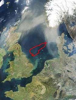
To the east of Great Britain, lies the Dogger Bank, a vast moraine, or accumulation of unconsolidated glacial debris, which rises up to 15 to 30 m (49 to 98 ft) deep.[6]
The Silver Pit is a hollow or valley-like depression that has been recognised since about 1843 by fishermen.[7][8] Nearby is the Silverpit crater, a controversial structure initially proposed to be an impact crater, though another interpretation is that it may result from the dissolution of a thick bed of salt which permitted the upper strata to collapse.[9] The Devil's Hole is a group of trenches 200 kilometres (120 mi) east of Dundee, Scotland which are up to 230 metres (750 ft) deep.[10] "The Long Forties" denotes a principal raised bank about 110 miles (180 km) in length that is between 35 and 40 fathoms (64 and 73 m) deep.[11][12] It is located parallel to the shore of Scotland between Kinnaird's Head and Aberdeen.[13] The Broad Fourteens are a sand bar ridge between eleven and fourteen fathoms (20 m and 26 m) deep located off the Flemish and Danish coasts.[11][14]
Coordinates
See also
References
- ↑ De Angelo, Laura; Eds. Cutler J. Cleveland (August 22, 2008). "North Sea, Europe - Encyclopedia of Earth". Environmental Information Coalition, National Council for Science and the Environment. Retrieved 2008-11-02.
- ↑ "Limits of Oceans and Seas, 3rd edition" (PDF). International Hydrographic Organization. 1953.
- ↑ Judd, Alan; Martin Hovland (2007). Seabed Fluid Flow: The Impact of Geology, Biology And the Marine Environment (Digitized by Google Books online). Bath, UK: Cambridge University Press. p. 10. ISBN 9780521819503. Retrieved 2009-01-10.
- ↑ "LIS No. 10 - North Sea 1974" (pdf). U.S. Department of State. United States Government. Retrieved 2008-11-02.
- ↑ "About the North Sea: Key facts". The Norwegian Coastal Administration. 2008. Retrieved 2008-11-02.
- ↑ "Dogger Bank". Maptech Online MapServer. 1989–2008. Retrieved 2007-07-20.
- ↑ Holdsworth, Edmund William Hunt (1883). The Sea Fisheries of Great Britain and Ireland: An Account of the Practical Working of the Various Fisheries Around the British Islands (Digitized 2007-11-30 by Google Books online). Bath, UK: E. Stanford. pp. 43–46. ISBN 9780898622720. Retrieved 2009-01-10.
- ↑ Straw, Allan; Keith Martin Clayton (1979). Eastern and Central England (Digitized 2007-11-30 by Google Books online). Bath, UK: Taylor & Francis. p. 110. ISBN 9780416846706. Retrieved 2009-01-10.
- ↑ Amos, Jonathan (2005-03-18). "North Sea crater shows its scars". BBC. Retrieved 2008-11-02.
- ↑ Fyfe, Alan (November 1983). "The Devil's Hole in the North Sea". The Edinburgh Geologist (14). Retrieved 2008-11-02.
- 1 2 Admiralty Hydrography Department (1878). North sea pilot. Pt. 1. 2nd- ed. [With] Suppl. [and] Admiralty notices to mariners. [1st] [With] Suppl. [and] Admiralty notices to mariners (Digitized 2006-06-12 by Google Books online) (3 ed.). London: Oxford University. pp. 36–40. Retrieved 2008-12-04.
- ↑ Library of Universal Knowledge: A Reprint of the Last (1880) Edinburgh and London Edition of Chambers' Encyclopaedia, with Copious Additions by American Editors (Digitized 2007-10-09 by Google Books online). American Book Exchange. 1880. p. 140. Retrieved 2008-12-27.
- ↑ Geological Society of London (1866). The Assistant-Secretary of the Geological Society, ed. The Quarterly Journal of the Geological Society of London (Digitized by Google Books online). 22. London: The Society. p. 260. ISSN 0370-291X. OCLC 1437164. Retrieved 2008-12-04.
- ↑ Institution of Civil Engineers (Great Britain) (1861). Minutes of Proceedings of the Institution of Civil Engineers (Digitized 2006-06-06 by Google Books online). London: O The Institution. p. 319. Retrieved 2009-01-10.
- 1 2 3 4 5 6 7 8 9 10 11 12 13 14 15 Wick, Marc (2008). "GeoNames Fulltextsearch: United Kingdom, undersea". GeoNames wiki interface. Retrieved 2008-11-28.
- 1 2 3 4 5 6 7 8 9 10 11 12 13 14 15 16 17 18 "VLIMAR, the VLIz MARine Gazetteer". Retrieved 2008-11-28. To expand the Geographic Tree and see the child Geographic names look in North Atlantic Ocean, North Sea.
- ↑ "LIS No. 10 - North Sea 1974" (pdf). International Boundary Study Series A Limits in the Seas North Sea Continental Shelf Boundaries. The Geographer, Bureau of Intelligence and Research of the Department of State. June 14, 1974. Retrieved 2008-12-05. To expand the Geographic Tree and see the child Geographic names look in North Atlantic Ocean, North Sea.
- ↑ "Flamborough Head". Special Areas of Conservation (SAC). Retrieved 2008-11-28.
- ↑ "VLIMAR, the VLIz MARine Gazetteer". Retrieved 2008-11-28.
- 1 2 3 4 "Observations Data". Retrieved 2008-11-28.
- ↑ Gaffney, Vincent; Simon Finch; Kenneth Thomson (2007). Mapping Doggerland: The Mesolithic Landscapes of the Southern North Sea (Digitized 2007-10-11 by Google Books online). Archaeopress. p. 43. ISBN 9781905739141. Retrieved 2008-12-26.
- ↑ Foschini L. (1999). "A solution for the Tunguska event". Astronomy & Astrophysics. 342: L1. arXiv:astro-ph/9808312
 . Bibcode:1999A&A...342L...1F. Abstract
 - ↑ The London Gazette: no. 26728. p. 2165. 7 April 1896.
- ↑ "Germany - Schleswig-Holstein Wadden Sea and adjacent areas". Retrieved 2008-11-28.
- ↑ "The Wash and North Norfolk Coast - Special Area of Conservation ...". Retrieved 2008-11-28.