List of rivers discharging into the North Sea
Table
| The main affluents of North Sea, Skagerrak and Kattegat | |||||
|---|---|---|---|---|---|
| Name | Mean Discharge | Length | Basin | States | Course |
| Rhine | 2900 m³/s (R-M-delta) 2300 m³/s (proper) | 1238.8 km (with Hinterrhein) 1240 km (with Vorderrhein) | 197,100 km2 (76,100 sq mi) (with Meuse)[1] | Switzerland (sources), Liechtenstein, Austria, Germany, France, Netherlands, Luxembourg (Moselle), Italy (Reno di Lei) | '''smallest flow': Dischmabach → Landwasser → Albula → Hinterrhein (sum = 72 km) → Rhine longest course: Rein da Medel → Vorderrhein (sum = 74 km)→ Rhine |
| Elbe | 870 m³/s | 1094 km (nominally) 1245 km (hydrologically) | 148,268 km2 (57,247 sq mi)[1] | the Czech Republic (sources), Germany, Austria (Lainsitz), Poland (Dzika Orlica and smaller affluents) | longer and larger tributary Vltava |
| Glomma | 698 m³/s | 601 km | 41,917 km2 (16,184 sq mi) | Norway, Sweden (affluents) | Glomma → lake Aursunden → Glomma → Skagerrak |
| Göta älv | 575 m³/s | 93 km (nominally) 720 km (hydrologically) | 50,229.3 km2 (19,393.6 sq mi) | Sweden, Norway (Trysilelva) | Rogen → lake Femund → Trysilelva → Klarälven → lake Vänern → Göta älv → Kattegat[2] |
| Meuse | 357 m³/s | 874 km | 33,000 km2 (13,000 sq mi)[1] | France (source), Belgium, Netherlands, Luxembourg (Chiers), Germany (Rur, S(ch)walm, Niers) | sharing mouths of the Rhine |
| Weser | 327 m³/s | 451.4 km (nominally) 751 km (with Werra) | 41,094 km2 (15,866 sq mi)[3] | Germany | formed by confluence of Werra (longer) and Fulda (larger) |
| Drammenselva | 314 m³/s | 48 km (nominally) 301 km (system) | 17,110 km2 (6,610 sq mi) | Norway | … → Slidrefjorden → Strondafjorden → Aurdalsfjorden → Begna → Sperillen → Ådalselva → Randselva → Storelva → Tyrifjorden → Drammenselva → Oslofjord |
| Humber (estuary) | 250 m³/s (without tide flows) | 62 km (nominally) 359 km (with Trent) | 24,240 km2 (9,360 sq mi)[4] | England | common estuary of Trent and Ouse (see below) |
| Tay | 170 m³/s | 193 km | 6,216 km2 (2,400 sq mi)[5] | Scotland | River Tay → Firth of Tay (estuary, included in the figures) |
| Otra | 150 m³/s | 245 km | 3,740 km2 (1,440 sq mi) | Norway | → Skagerrak |
| Sira | 130 m³/s | 152 km | 1.902 km2 (0.734 sq mi) | Norway | |
| Scheldt | 127 m³/s | 360 km | 21,863 km2 (8,441 sq mi)[1] | France (source). Belgium, Netherlands (estuary) | |
| River Forth | 112 m³/s | 47 km (nominally) 55 km (hydrologically) | 1,029 km2 (397 sq mi)[6][7] | Scotland | → Firth of Forth |
| Numedalslågen | 111 m³/s | 352 km | 5,554 km2 (2,144 sq mi) | Norway | → Skagerrak |
| Trent | 99 m³/s | 297 km | 10,452 km2 (4,036 sq mi) | England | → Humber (see above) |
| Tweed | 85 m³/s | 156 km | 1,080 km2 (420 sq mi)[8] | Scotland (source). England | |
| Lagan | 82 m³/s | 244 km | 6,451.8 km2 (2,491.1 sq mi) | Sweden | → Kattegat[2] |
| Ems | 80.5 m³/s | 371 km | 13,160 km2 (5,080 sq mi)[1] | Germany, Netherlands (estuary) | |
| Thames | 65.8 m³/s | 346 km | 12,935 km2 (4,994 sq mi)[9] | England | |
| Spey | 64 m³/s | 173 km | 3,008 km2 (1,161 sq mi)[10] | Scotland | → Moray Firth |
| Ätran | 52.5 m³/s | 243 km | 3,342.2 km2 (1,290.4 sq mi) | Sweden | → Kattegat[2] |
| River Tyne | 44.6 m³/s | 321.4 km | 2,200 km2 (850 sq mi)[3] | England | |
| Yorkshire Ouse | 44 m³/s | 208 km (with Ure) | 3,315 km2 (1,280 sq mi) | England | Ure → Ouse → Humber (see above) |
| Nissan | 41 m³/s | 200 km | 2.6857 km2 (1.0370 sq mi) | Sweden | → Kattegat |
| Skjern Å | 36.6 m³/s | 94 km | 2,100 km2 (810 sq mi)[11] | Denmark | → Ringkøbing Fjord (lagoon) |
| Great Ouse | 35 m³/s | 270 km | 8,530 km2 (3,290 sq mi) | England | → The Wash |
| Gudenå | 32.4 m³/s[12] | 149 km | 2,643 km2 (1,020 sq mi)[11] | Denmark | → Kattegat[2] |
Long list
Austrian drainage basin
- Elbe (near Cuxhaven, Germany)
- Vltava (in Mělník, Czech Republic)
- Lužnice/Lainsitz (in Týn nad Vltavou, Czech Republic)
- Vltava (in Mělník, Czech Republic)
johibuhubibuhuhbu pixel mon minecraft gfytxtfygvyuifi6y
- Rhine/Rhein (main branch at Hoek van Holland, Netherlands)
- Bregenzer Ach (into Lake Constance in Bregenz)
- Dornbirner Ach (into Lake Constance near Bregenz)
- Ill (near Feldkirch)
Belgian drainage basin
- Yser (in Nieuwpoort) - France, Belgium
Danish drainage basins
English drainage basins
Flowing into the North Sea - Thames and Medway
From Foreness Point to Shoeburyness
- River Medway (shares the Thames estuary)
- River Thames (From Oxford up to its source, the Thames is also known as the River Isis)
- River Darent
- River Ingrebourne (tidal reach known as Rainham Creek)
- River Beam (downstream name for River Rom)
- River Roding (tidal reach known as Barking Creek)
- River Lea (or Lee)
- River Moselle (mostly subterranean, original tributary of Lee, now empties into Pymme's Brook)
- The Hackney Brook (subterranean, and probably now diverted to the Thames)
- New River (artificial distributary, partly subterranean)
- River Beane
- River Mimram
- River Ravensbourne (tidal reach known as Deptford Creek)
- Spring Brook
- River Pool
- River Beck
- Chaffinch Brook
- River Quaggy (upper reaches known as Kyd Brook)
- Quaggy Hither Green
- Middle Kid Brooke
- Lower Kid Brooke
- Little Quaggy
- Grove Park Ditch
- Milk Street Ditch
- East Branch
- Main Branch
- River Neckinger (See also Subterranean rivers of London for this and the others marked 'subterranean' below)
- Walbrook (subterranean)
- River Fleet (subterranean, also known as the Holbourne)
- River Effra (subterranean)
- River Tyburn (subterranean)
- Falconbrook (subterranean)
- River Westbourne (subterranean)
- Tyburn Brook (subterranean)
- Counter's Creek (subterranean)
- River Wandle
- Beverley Brook
- Stamford Brook (subterranean - tidal reach known as Hammersmith Creek)
- Bollar or Bollo Brook (subterranean)
- River Brent
- Duke of Northumberland's River
- River Crane
- Hogsmill River
- The Rythe
- River Ember
- Longford River
- River Ash
- River Wey
- River Bourne, north branch
- River Bourne, south branch
- River Colne
- Colne Brook
- River Wye
- River Loddon
- River Kennet
- River Pang
- River Thame
- River Ock
- River Cherwell
- River Ray
- River Swere
- River Evenlode
- River Windrush
- River Cole
- River Leach
- River Coln
- River Ray
- River Key
- River Churn
Flowing into the North Sea - North of the Thames Estuary
The mouth of the Gaywood River at King's Lynn.
.JPG)
The Mouth of the River Burn at Overy Creek, Norfolk
From Shoeburyness to St Abb's Head
- River Crouch
- River Blackwater
- River Colne
- River Stour
- River Orwell
- River Deben
- River Alde/River Ore
- Minsmere River
- River Blyth
- River Yox
- River Yare
- River Burn
- River Great Ouse
- River Nene
- River Welland
- Whaplode River
- New River
- Car Dyke (Peterborough)
- Eye Brook
- River Chater
- River Gwash
- Vernatt's Drain
- South Drove Drain
- River Glen
- West Glen River
- East Glen River
- Bourne Eau
- Risegate Eau
- Boston Haven
- South Forty-Foot Drain
- Hammond Beck
- North Forty Foot Drain
- Clay Dike
- Skerth Drain
- River Witham
- River Slea
- Billinghay Skirth
- River Brant
- Fossdyke Navigation
- River Bain
- Newham Drain
- Castle Dike
- Maud Foster Drain
- West Fen Drain
- Medlam Drain
- Stone Bridge Drain
- West Fen Catchwater Drain
- East Fen Catchwater Drain
- West Fen Drain
- Hobhole Drain
- Cowbridge Drain
- Bell Water Drain
- Fodder Dike
- South Forty-Foot Drain
- Steeping River
- River Lymn
- Cow Bank Drain
- Saltfleet Haven
- Grainthorpe Haven
- River Lud Canalised and diverted as Louth Navigation.
- Tetney Haven
- Louth Navigation
- Waithe Beck
- Louth Navigation
- River Humber
- Buck Beck
- River Freshney
- East Halton Beck
- The Beck
- River Ancholme
- West Drain
- Halton Drain
- River Trent
- River Ouse
- Swinefleet Warping Drain
- River Don
- River Aire
- River Derwent
- River Wharfe
- River Foss
- River Nidd
- River Ure
- River Hull
- Sands Drain
- Winestead Drain
- Gypsey Race
- Sea Cut (Scalby Beck)
- River Esk
- Iburndale Beck
- Little Beck
- May Beck
- Little Beck
- Iburndale Beck
- Skelton Beck
- River Tees
- River Wear
- River Browney
- River Deerness
- River Gaunless
- River Browney
- River Tyne
- River South Tyne
- River North Tyne
- Warks Burn
- Chirdon Burn
- Lewis Burn
- Devil's Water
- River Derwent
- River Team
- River Blyth
- River Wansbeck
- River Coquet
- River Aln
- River Tweed
- Whiteadder Water, Scotland
- Blackadder Water, Scotland
- River Till
- Eden Water, Scotland
- River Teviot, Scotland
- Leader Water, Scotland
- Gala Water, Scotland
- Ettrick Water, Scotland
- Leithen Water, Scotland
- Quair Water, Scotland
- Eddleston Water, Scotland
- Manor Water, Scotland
- Holms Water, Scotland
- Whiteadder Water, Scotland
French drainage basin
Aa River
The Aa is an 89 km long river in northern France. Its source is near the village Bourthes. It flows through the départements and cities of Pas-de-Calais: Saint-Omer and Nord: Gravelines.
- Aa (in Gravelines)
German drainage basin
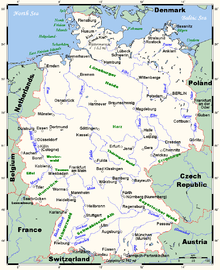
The major German rivers
The three main rivers in Germany are the Rhine (Rhein in German) (main tributaries including the Neckar, the Main and the Moselle (Mosel)); the Elbe (also drains into the North Sea); and, the Danube (Donau).
German rivers draining into the North Sea
The rivers in this section are sorted south-west (Netherlands) to east (Danish border).
- Maas (main branch at Stellendam, Netherlands)
- Rhine/Rhein (main branch at Hoek van Holland, Netherlands)
- Lippe (in Wesel)
- Emscher (near Dinslaken)
- Ruhr (in Duisburg)
- Volme (near Hagen)
- Lenne (near Hagen)
- Möhne (in Neheim-Hüsten)
- Erft (in Neuss)
- Wupper/Wipper (in Leverkusen)
- Sieg (in Bonn)
- Ahr (near Sinzig)
- Wied (in Neuwied)
- Moselle (in Koblenz)
- Elzbach (in Moselkern)
- Alf (in Alf)
- Lieser (near Bernkastel-Kues)
- Salm (near Klüsserath)
- Kyll (near Trier-Ehrang)
- Saar (near Konz)
- Nied (near Rehlingen-Siersburg)
- Prims (in Dillingen)
- Blies (in Sarreguemines)
- Schwarzbach (near Zweibrücken)
- Sauer (in Wasserbillig)
- Prüm (near Echternach)
- Our (in Wallendorf)
- Lahn (in Lahnstein)
- Nahe (in Bingen)
- Alsenz (near Bad Kreuznach)
- Glan (near Bad Sobernheim)
- Selz (in Ingelheim)
- Main (in Mainz)
- Nidda (in Frankfurt-Höchst)
- Kinzig (in Hanau)
- Tauber (in Wertheim am Main)
- Fränkische Saale (in Gemünden am Main)
- Regnitz (in Bamberg)
- Pegnitz (in Fürth)
- Rednitz (in Fürth)
- Fränkische Rezat (in Georgensgmünd)
- Schwäbische Rezat (in Georgensgmünd)
- Itz (in Baunach)
- Red Main (near Kulmbach)
- Neckar (in Mannheim)
- Jagst (near Bad Friedrichshall)
- Kocher (in Bad Friedrichshall)
- Enz (in Besigheim)
- Murr (in Marbach am Neckar)
- Rems (in Remseck)
- Fils (in Plochingen)
- Queich (near Germersheim)
- Pfinz (near Germersheim)
- Lauter (in Lauterbourg)
- Murg (near Rastatt)
- Sauer (in Seltz, France)
- Acher (near Lichtenau)
- Rench (near Lichtenau)
- Kinzig (near Kehl)
- Elz (near Lahr)
- Wiese (near Basel)
- Wutach (in Waldshut-Tiengen)
- IJssel (into the IJsselmeer near Kampen, Netherlands)
- Berkel (in Zutphen, Netherlands)
- Oude IJssel/Issel (in Doesburg, Netherlands)
- Zwarte Water (into the IJsselmeer near Genemuiden, Netherlands)
- Ems (near Delfzijl, Netherlands)
- Weser (near Bremerhaven)
- Hunte (in Elsfleth)
- Lesum (in Bremen-Vegesack)
- Wümme (in Ritterhude)
- Aller (near Verden (Aller))
- Böhme (near Rethem)
- Leine (near Schwarmstedt)
- Örtze (in Winsen an der Aller)
- Fuhse (in Celle)
- Oker (in Müden (Aller))
- Schunter (near Braunschweig)
- Werre (in Bad Oeynhausen)
- Diemel (in Bad Karlshafen)
- Fulda (in Hannoversch Münden)
- Werra (in Hannoversch Münden)
- Hörsel (near Eisenach)
- Ulster (in Philippsthal)
- Elbe (near Cuxhaven)
- Oste (near Otterndorf)
- Stör (near Glückstadt)
- Alster (in Hamburg)
- Bille (near Hamburg)
- Ilmenau (near Winsen (Luhe))
- Jeetzel (in Hitzacker)
- Löcknitz (near Dömitz)
- Aland (in Schnackenburg)
- Stepenitz (in Wittenberge)
- Havel (near Havelberg)
- Ohre (near Magdeburg)
- Saale (in Barby)
- Bode (in Nienburg (Saale))
- Wipper (Saale) (near Bernburg)
- White Elster (near Halle (Saale))
- Unstrut (near Naumburg)
- Wipper (Unstrut) (near Heldrungen)
- Gera (in Straußfurt)
- Ilm (in Großheringen)
- Schwarza (in Schwarza)
- Mulde (in Dessau)
- Zwickauer Mulde (near Colditz)
- Chemnitz (near Wechselburg)
- Freiberger Mulde (near Colditz)
- Zwickauer Mulde (near Colditz)
- Black Elster (near Wittenberg)
- Weißeritz (in Dresden)
- Wilde Weißeritz (in Freital)
- Wesenitz (in Pirna)
- Ohře/Eger (in Litoměřice, Czech Republic)
- Vltava (in Mělník, Czech Republic)
- Eider (in Tönning)
- Treene (in Friedrichstadt)
Netherlands drainage basin
- Zwarte Water (into IJsselmeer near Genemuiden) - Netherlands
- IJssel (into IJsselmeer near Kampen) - Netherlands
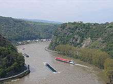
The Rhine at the Loreley
- Rhine/Rhein (main branch at Hoek van Holland) - Switzerland, Liechtenstein, Austria, Germany, France, Belgium, Netherlands
- Linge (in Gorinchem)
- Lippe (in Wesel)
- Emscher (near Dinslaken)
- Ruhr (in Duisburg)
- Düssel (in Düsseldorf)
- Erft (in Neuss)
- Wupper (in Leverkusen)
- Sieg (in Bonn)
- Ahr (near Sinzig)
- Wied (in Neuwied)
- Moselle (in Koblenz)
- Kyll (near Trier-Ehrang)
- Ruwer (near Trier-Ruwer)
- Saar (near Konz)
- Nied (near Rehlingen-Siersburg)
- Sauer (in Wasserbillig)
- Prüm (near Echternach)
- Our (in Wallendorf)
- Alzette (in Ettelbrück)
- Seille (in Metz)
- Meurthe (in Frouard)
- Madon (in Neuves-Maisons)
- Vologne (near Éloyes)
- Moselotte (in Remiremont)
- Lahn (in Lahnstein)
- Nahe (in Bingen)
- Main (in Mainz)
- Nidda (in Frankfurt-Höchst)
- Kinzig (in Hanau)
- Tauber (in Wertheim am Main)
- Franconian Saale (in Gemünden)
- Regnitz (in Bamberg)
- Pegnitz (river) (in Fürth)
- Rednitz (in Fürth)
- Neckar (in Mannheim)
- Jagst (near Bad Friedrichshall)
- Kocher (in Bad Friedrichshall)
- Enz (in Besigheim)
- Fils (in Plochingen)
- Lauter (in Lauterbourg)
- Murg (near Rastatt)
- Ill (near Strasbourg)
- Kinzig (near Kehl)
- Elz (near Lahr)
- Wiese (in Basel)
- Aare (in Koblenz)
- Thur (near Schaffhausen)
- Ill (near Feldkirch)
- Vorderrhein (near Chur)
- Hinterrhein (near Chur)

- Meuse/Maas (main branch near Hellevoetsluis) - France, Belgium, Netherlands
- Dieze (near 's-Hertogenbosch)
- Aa (in 's-Hertogenbosch)
- Dommel (in 's-Hertogenbosch)
- Niers (in Gennep)
- Swalm (in Swalmen)
- Rur/Roer (in Roermond)
- Geul (near Meerssen)
- Jeker/Geer (in Maastricht)
- Ourthe (in Liège)
- Vesdre (near Liège)
- Amblève (in Comblain-au-Pont)
- Salm (in Trois-Ponts)
- Sambre (in Namur)
- Lesse (in Dinant-Anseremme)
- Viroin (in Vireux-Molhain)
- Semois/Semoy (in Monthermé)
- Bar (near Dom-le-Mesnil)
- Chiers (in Bazeilles)
- Dieze (near 's-Hertogenbosch)

The Scheldt in Antwerp
- Scheldt/Schelde/Escaut (near Flushing, Netherlands) - France, Belgium, Netherlands
Norwegian drainage basin
- Otta (in Oppland into Gudbrandsdalslågen at Otta)
- Gudbrandsdalslågen (into Lake Mjøsa in Oppland)
- Vorma (out of Lake Mjøsa into Glomma at Årnes)
- Glomma (into Oslofjord at Fredrikstad)
- Renaelva (in Hedmark into Glomma at Åmot)
- Numedalslågen (in Larvik, Vestfold)
- Hallingdalselva (through Hallingdal into Lake Krøderen, Buskerud)
- Begna (in Buskerud)
- Dramselva (into Oslofjord in Drammen, Buskerud)
- Skien (into Møsvatn, Telemark)
- Tinn (into Møsvatn, Telemark)
- Nidelva (in Arendal, Aust-Agder)
- Otra (in Kristiansand, Vest-Agder)
Scotland drainage basin
- Tyne (near Dunbar)
- Tay (near Dundee)
- Dee (in Aberdeen)
- Don (in Aberdeen)
- Ythan (in Newburgh, Aberdeenshire)
- Spey (near Elgin)
Swedish drainage basin
- Göta älv (into Kattegat in Gothenburg)
- Lake Vänern
- Klarälven/Trysilelva (into Vänern near Karlstad)
- Lake Vänern
- Viskan (into Kattegat near Varberg)
- Ätran (into Kattegat in Falkenberg)
- Nissan (into Kattegat in Halmstad)
- Lagan (into Kattegat near Laholm)
Switzerland drainage basin
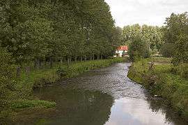
The Rhine, together with its tributaries the Aare and the Thur drain about two thirds of the water into the North Sea.
See also
- Drainage basin
- European river zonation
- Geography of Europe
- Geography of Germany
- Geography of the North Sea
- Geography of Switzerland
- List of European rivers with alternative names
- Latin names of European rivers
- List of rivers of England
References
- 1 2 3 4 5 McAlister, Elaine; Nelleke Domburg; Tony Edwards; Bob Ferrier. "Hydrological Modelling of the River Ythan using ArcInfo GRID". Macaulay Land Use Research Institute. Archived from the original on 2008-07-26. Retrieved 2008-12-04.
- 1 2 3 4 Leibniz-Institut für Ostseeforschung Warnemünde: Gehört das Kattegatt noch zur Ostsee (Is the Kattegat a part of the Baltic Sea?) → By physical criteria, the border between North Sea and Baltic sea is in the Øresund at Drodgen Sill and in the Great Belt near Langeland
- 1 2 Milliman, John D.; Syvitski, James P. M. "Geomorphic/Tectonic Control of Sediment Discharge to the Ocean: The Importance of Small Mountainous Rivers". Woods Hole Oceanographic Institution. Retrieved 2008-12-04.
- ↑ Appleton, Tamsin (24 November 2008). "Environment Agency - More about Humber RBD" (cached). Subjects > Water Quality > WFD > RBD information > Humber RBD > More about Humber RBD. The Environment Agency. Retrieved 2008-12-04.
- ↑ Hopkin, John; Duffy, Philip; Blades, Heather (2002). "What causes the River Tay in Scotland to flood?". Geography Matters Scotland (Digitized by Google Books online). Heinemann. p. 132. ISBN 978-0-435-35543-2. Retrieved 2008-12-05.
- ↑ http://www,sepa,org,uk/system_pages/search,aspx?q=Forth
- ↑ "Information Sheet on Ramsar Wetlands (RIS)" (pdf). Ramsar Information Sheet: UK13017 Firth of Forth. JNCC: Version 3.0,. 13 June 2008. Retrieved 2008-12-04.The catchment area of both the River Forth and Firth of Forth Estuary.
- ↑ http://www,ask,com/question/where-is-the-river-tweed
- ↑ Ojo, Michael; Fuller, Terence W. (12 July 2007). "London Councils' TEC Executive Sub-Committee Water Framework Directive" (doc). Babtie Group. Retrieved 2008-12-04.
- ↑ Riddell, Keith J.; Fuller, Terence W. "The Spey Bay geomorphological study". Babtie Group. Retrieved 2008-12-04.
- 1 2 Miljø og Energiministeriet: Afstrømningsforhold i danske vandløb (2000), p. 16
- ↑ A bit lesser than Skjern Å
This article is issued from Wikipedia - version of the 11/9/2016. The text is available under the Creative Commons Attribution/Share Alike but additional terms may apply for the media files.