Georgia State Route 171
| ||||
|---|---|---|---|---|
 | ||||
| Route information | ||||
| Maintained by GDOT | ||||
| Length: | 76.9 mi[1] (123.8 km) | |||
| Major junctions | ||||
| South end: |
| |||
|
| ||||
| North end: |
| |||
| Location | ||||
| Counties: | Treutlen, Emanuel, Johnson, Jefferson, Glascock, Warren | |||
| Highway system | ||||
| ||||

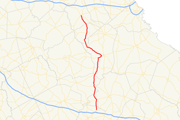
State Route 171 (SR 171) is a 76.9-mile-long (123.8 km) state highway that runs south-to-north through portions of Treutlen, Emanuel, Johnson, Jefferson, Glascock, and Warren counties in the east-central part of the U.S. state of Georgia.
Route description
SR 171 begins at an intersection with US 221/SR 56, northeast of Soperton, in Treutlen County. US 221/SR 171 run concurrent for just over half of SR 171's length. A little ways north of that point, the two highways cross into Emanuel County and then, the Ohoopee River. They meet US 80/SR 26. They curve to the northwest, then curve back to the northeast. After a brief entrance into Johnson County, and a longer re-entrance to Emanuel County, the concurrency enters Johnson County again. They continue to the northeast and then curve to the northwest to the town of Kite, where they meet SR 57. They continue to the north and begin a gradual curve to the northeast to enter Jefferson County. The routes meet US 319/SR 78, which join the concurrency. Just before entering Bartow, they intersect SR 242. In town, US 319/SR 78 depart to the east. US 221/SR 171 continue to the north, until they meet SR 24, which joins the concurrency. The three highways head to the northeast until a point just southwest of Louisville. There, SR 171 departs to the northwest. Farther to the northwest is SR 88 (Jefferson Davis Memorial Highway). It continues to the northwest to enter Glascock County. It curves to the northeast, until it enters the town of Gibson. There, it meets SR 102. The road heads north and curves to the northwest to enter Warren County. SR 171 continues to the northwest until it meets its northern terminus, an intersection with US 278 Bypass/SR 12 Bypass, in Warrenton.[1]
Major intersections
| County | Location | mi[1] | km | Destinations | Notes | |||
|---|---|---|---|---|---|---|---|---|
| Treutlen | | 0.0 | 0.0 | Southern terminus | ||||
| Emanuel | Ohoopee River | 2.8 | 4.5 | Unnamed bridge | Crossing over the Ohoopee River | |||
| | 6.9 | 11.1 | ||||||
| Johnson |
No major junctions | |||||||
| Emanuel |
No major junctions | |||||||
| Johnson | Kite | 17.1 | 27.5 | |||||
| Jefferson | Little Ohoopee River | 20.1 | 32.3 | Unnamed bridge | Crossing over the Little Ohoopee River | |||
| | 27.4 | 44.1 | Southern end of US 319/SR 78 concurrency | |||||
| | 30.7 | 49.4 | Eastern terminus of SR 242 | |||||
| Bartow | 31.0 | 49.9 | Northern end of US 319/SR 78 concurrency | |||||
| | 38.0 | 61.2 | Southern end of SR 24 concurrency | |||||
| Ogeechee River | 39.5 | 63.6 | Unnamed bridge | Crossing over the Ogeechee River | ||||
| | 40.8 | 65.7 | Northern end of US 221 & SR 24 concurrencies | |||||
| | 50.9 | 81.9 | ||||||
| Glascock | Gibson | 64.1 | 103.2 | Southern end of SR 102 concurrency | ||||
| 64.1 | 103.2 | Northern end of SR 102 concurrency | ||||||
| Warren | Warrenton | 76.9 | 123.8 | Northern terminus | ||||
1.000 mi = 1.609 km; 1.000 km = 0.621 mi
| ||||||||
See also
-
.svg.png) Georgia (U.S. state) portal
Georgia (U.S. state) portal -
 U.S. Roads portal
References
- 1 2 3 Google (June 23, 2013). "Route of SR 171" (Map). Google Maps. Google. Retrieved June 23, 2013.