Gooderstone
| Gooderstone | |
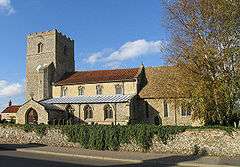 St George, Gooderstone |
|
 Gooderstone |
|
| Area | 11.29 km2 (4.36 sq mi) |
|---|---|
| Population | 363 (2011 census[1] |
| – density | 32/km2 (83/sq mi) |
| OS grid reference | TF7622002111 |
| District | Breckland |
| Shire county | Norfolk |
| Region | East |
| Country | England |
| Sovereign state | United Kingdom |
| Post town | Kings Lynn |
| Postcode district | PE33 |
| Dialling code | 01366 |
| Police | Norfolk |
| Fire | Norfolk |
| Ambulance | East of England |
| EU Parliament | East of England |
| UK Parliament | South West Norfolk |
Coordinates: 52°35′16″N 0°36′06″E / 52.587835°N 0.601598°E
Gooderstone is a village situated in the Breckland District of Norfolk and covers an area of 11.29 km2 (4.36 sq mi) with an estimated population of 390 in 2007,[2] reducing to 363 at the 2011 Census. It lies 6 miles (9.7 km) south west from Swaffham.
Gooderstone is served by St.Georges church[3][4] in the Benefice of Cockley Cley.[5]
Gooderstone Primary School also serves the villages of Foulden and Oxborough.
Gooderstone Water Gardens and Nature Trail is open daily throughout the year.
References
| Wikimedia Commons has media related to Gooderstone. |
- ↑ "Civil Parish population 2011". Neighbourhood Statistics. Office for National Statistics. Retrieved 4 August 2016.
- ↑ Breckland Yearbook
- ↑ St.Georges
- ↑ Norfolk churches
- ↑ Benefice of Cockley Cley
This article is issued from Wikipedia - version of the 8/5/2016. The text is available under the Creative Commons Attribution/Share Alike but additional terms may apply for the media files.