Shropham
| Shropham | |
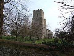 St. Peter and St. Paul, Shropham |
|
 Shropham |
|
| Area | 11.12 km2 (4.29 sq mi) |
|---|---|
| Population | 351 |
| – density | 32/km2 (83/sq mi) |
| OS grid reference | TL984931 |
| – London | A |
| Civil parish | Shropham |
| District | Breckland |
| Shire county | Norfolk |
| Region | East |
| Country | England |
| Sovereign state | United Kingdom |
| Post town | ATTLEBOROUGH |
| Postcode district | NR17 |
| Dialling code | 01953 |
| Police | Norfolk |
| Fire | Norfolk |
| Ambulance | East of England |
| EU Parliament | East of England |
Coordinates: 52°30′00″N 0°55′19″E / 52.500°N 0.922°E
Shropham is a civil parish in the English county of Norfolk. It covers an area of 11.12 km2 (4.29 sq mi) and had a population of 351 in 155 households at the 2001 census.[1] For the purposes of local government, it falls within the district of Breckland.
Its main attraction is the Church of St. Peter and St. Paul, built in flint in the Perpendicular style.
The village is listed in the Domesday Book under the name Scerpham.
Notable residents
- Mary E. Mann (1848–1929), writer, lived in the village.[2]
- Justin Fashanu (1961–1998), footballer, used to live in the village.
- John Fashanu (1962-), footballer, used to live in the village.
Notes
| Wikimedia Commons has media related to Shropham. |
- ↑ Census population and household counts for unparished urban areas and all parishes. Office for National Statistics & Norfolk County Council (2001). Retrieved 20 June 2009.
- ↑ EDP24 Features
This article is issued from Wikipedia - version of the 12/23/2014. The text is available under the Creative Commons Attribution/Share Alike but additional terms may apply for the media files.