Thompson, Norfolk
| Thompson | |
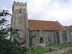 St Martin's Church, Thompson |
|
 Thompson |
|
| Area | 9.20 km2 (3.55 sq mi) |
|---|---|
| Population | 343 (2011 census)[1] |
| – density | 37/km2 (96/sq mi) |
| OS grid reference | TL923965 |
| Civil parish | Thompson, Norfolk |
| District | Breckland |
| Shire county | Norfolk |
| Region | East |
| Country | England |
| Sovereign state | United Kingdom |
| Post town | THETFORD |
| Postcode district | IP24 |
| Police | Norfolk |
| Fire | Norfolk |
| Ambulance | East of England |
| EU Parliament | East of England |
| Website | http://www.thompsonvillage.org.uk/ |
Coordinates: 52°31′59″N 0°50′07″E / 52.53317°N 0.83521°E
Thompson is a civil parish in the English county of Norfolk. It covers an area of 9.20 km2 (3.55 sq mi) and including Tottington had a population of 341 in 147 households at the 2001 census,[2] increasing to a population of 343 in 155 househods at the 2011 Census. For the purposes of local government, it falls within the district of Breckland.
Thompson is a relatively secluded village in Norfolk, England, located amongst acres of woodland, the nearest town being Watton.
In this region the name Thompson is believed to have Danish origins, as it was part of the Danelaw after centuries of invasion. The village is recorded in the 11th-century Domesday Book as Tomesteda and Tomestuna.
References
- ↑ "Civil Parish population 2011". Neighbourhood Statistics. Office for National Statistics. Retrieved 14 August 2016.
- ↑ Census population and household counts for unparished urban areas and all parishes. Office for National Statistics & Norfolk County Council (2001). Retrieved 20 June 2009.
External links
![]() Media related to Thompson, Norfolk at Wikimedia Commons
Media related to Thompson, Norfolk at Wikimedia Commons