Yaxham
| Yaxham | |
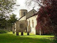 Yaxham St. Peter |
|
 Yaxham |
|
| Area | 6.64 km2 (2.56 sq mi) |
|---|---|
| Population | 677 (2001 census[1]) 722 (2011)[2] |
| – density | 102/km2 (260/sq mi) |
| OS grid reference | TG005105 |
| Civil parish | Yaxham |
| District | Breckland |
| Shire county | Norfolk |
| Region | East |
| Country | England |
| Sovereign state | United Kingdom |
| Post town | DEREHAM |
| Postcode district | NR19 |
| Police | Norfolk |
| Fire | Norfolk |
| Ambulance | East of England |
| EU Parliament | East of England |
| Website | http://www.yaxham-village.co.uk/index.jsp |
Coordinates: 52°39′19″N 0°57′56″E / 52.65518°N 0.965425°E
Yaxham is a village and civil parish in centre of the English county of Norfolk. The parish includes the village of Yaxham, together with the neighbouring community of Clint Green. Together, they lay some 2 miles (3.2 km) south of Dereham and 20 miles (32 km) west of Norwich.[3]
The civil parish has an area of 6.64 km2 (2.56 sq mi) and in the 2001 census had a population of 677 in 290 households, the population increasing to 722 in 340 households at the 2011 Census. For the purposes of local government, the parish falls within the district of Breckland.[1]
Yaxham Mill is the local pub. There are several other holiday cottages for rent in and around the village as well as a range of small businesses, covering Complementary Therapies, IT, Photography, Podiatry, Public Relations and Social Housing.
"Yaxham St. Peter" is one of 124 existing round-tower churches in Norfolk. There is an Evangelical Congregational church in Clint Green. The Village is home to Yaxham CE VA Primary School.
Yaxham railway station in the village is on the Mid-Norfolk Railway, a heritage railway running between the historic market towns of Wymondham and Dereham. The Yaxham Light Railway can also be found adjacent to the railway station.
See also
Notes
- 1 2 Census population and household counts for unparished urban areas and all parishes. Office for National Statistics & Norfolk County Council (2001). Retrieved 20 June 2009.
- ↑ "Civil Parish population 2011". Neighbourhood Statistics. Office for National Statistics. Retrieved 15 August 2016.
- ↑ Ordnance Survey (1999). OS Explorer Map 238 - East Dereham & Aylsham. ISBN 0-319-21869-4.
External links
| Wikimedia Commons has media related to Yaxham. |
- Map sources for Yaxham.
- Map sources for Clint Green
- Yaxham Village Website
- Information from Genuki Norfolk on Yaxham.
- Website with photos of Yaxham St. Peter, a round-tower church
- Yaxham light railway
- Yaxham Heritage Initiative