Gorbals
Coordinates: 55°50′55″N 4°15′08″W / 55.84861°N 4.25222°W
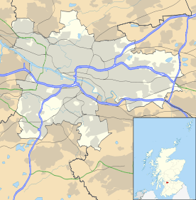
The Gorbals is an area on the south bank of the River Clyde in the city of Glasgow, Scotland. By the late 19th century it had become over-populated and adversely affected by local industrialisation. Many people lived here because their jobs provided their homes and they could not afford their own. It became widely known as a dangerous slum associated with the problems of drunkenness and crime. It was subject to efforts at redevelopment, which contributed to more problems such as homelessness and the spread of disease. In recent decades, much of the area has been demolished and redeveloped with a mixture of market and social housing. Some buildings are being refurbished and restored to a higher standard.
Currently there is an active campaign to reinstate the Cross fountain, organised by locals and Facebook page, Old Gorbals Pictures (Heritage Group). The group have discovered that a copy of the original cross exists on the Caribbean Island of St Kitts & Nevis and are working to engage professional help to digitally scan this object to allow for the manufacture of another Gorbals Cross, No 3 to be built in the new development near to where it originally stood.
Meaning of placename
The name is first documented in the 15th and 16th centuries as 'Gorbaldis', and its etymology is unclear. It may be related to the Latin word garbale (sheaf), found in the Scots term garbal teind (tenth sheaf), a tithe of corn given to a parish rector. The taking of garbal teind was a right given to George Elphinstone in 1616 as part of his 19-year tack (lease). The placename would therefore mean "the Sheaves". The name is remarkably similar to a Lowland Scots word gorbal/gorbel/garbal/garbel (unfledged bird), perhaps a reference to lepers who were allowed to beg for alms in public. Any Gaelic form of the name is conjectural, since none survives from medieval times. Gort a' bhaile (garden of the town) conforms with certain suggestions made by A.G. Callant in 1888, but it is possible to produce a list of other interpretations.
In the 19th and 20th centuries, the area was home to large numbers of immigrants from the Scottish Highlands, Italy and Ireland, attracted by the industrial jobs and leaving social problems and poverty in their homelands. It also housed the new wave of Jewish immigrants from Eastern and Central Europe, and housed the great majority of Scotland's Jewish population. The Jewish population moved out of the area as it rose in education and economic class; although the Irish-Catholic population has diminished to an extent, many have remained since the area's redevelopment.
History
Govan parish was one of the oldest possessions of the church in the region. The merk land of "Brigend and Gorbaldis" is referred to in several sources. The village of Brigend was named after the bridge which Bishop William Rae had built in 1345 over the River Clyde; it lasted until the 19th century. Lady Marjorie Stewart of Lochow was said to have had a hospital built for lepers and dedicated to St Ninian in 1350, although this year is contested by current historians' estimates dating her life and activities. The lands on which the hospital was built were named St Ninian's Croft, and they were later to be incorporated into Hutchesontown.[1]

After the Protestant Reformation, in 1579 the church granted the land for ground rents (feued the land) to Sir George Elphinstone, a merchant who was Provost of Glasgow (1600–1606). The barony and regality of the Gorbals was confirmed in 1606 by a charter of King James VI, which vested Elphinstone and his descendants. These powers descended to Sir Robert Douglas of Blackerstone, who in 1650 disponed (legally transferred) the Gorbals to Glasgow's magistrates for the benefit of the city, the Trades' House, and Hutchesons' Hospital. The magistrates from then on collected the rents and duties and divided them: one fourth to the city, one fourth to the Trades' House, and the remaining half to Hutchesons' Hospital.[1]
In 1790 the lands were divided into lots for development; the City acquired the old feus of Gorbals and Bridgend, and also the Kingston portion of the Barony of Gorbals; the Trades' House obtained a western section; and the remaining section lying to the east and south was allocated to Hutchesons' Hospital. The Hutcheson's Trust then sub-feud a portion of their lands to an ambitious builder, James Laurie. (His grave, along with those of many other builders of Gorbals, is marked with well-carved masons' implements, indicating his Master status. The gravestones are visible at the Burial Ground, established in 1715 and now called the Gorbals Rose Garden). Laurie built the first house in St Ninian Street in 1794.[1]
The districts are now known as the Gorbals, Laurieston, Tradeston, Kingston and Hutchesontown. The Little Govan estate, including a small village of the same name, were replaced by the eastern parts of Hutchesontown and Oatlands. The Gorbals was a successful industrial suburb in the late 19th century, and attracted many Catholic immigrants from Ireland and Italy, as well as Jewish immigrants from Russia and Eastern Europe. At one time this area had the great majority of all Jews in Scotland. Industrial decay and over-population overwhelmed the area, which became a centre of poverty.[1] Gorbals railway station opened on 1 September 1877. Changes in the area meant a decrease in business, and it closed to passengers permanently on 1 June 1928.
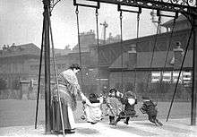

The Gorbals has long had a reputation as a gritty and rough area of Glasgow. In the 1870s, the City Improvement Trust cleared away the old Gorbals village and redeveloped the area to form the new Gorbals Cross, at the same time developing new workers' tenements around the former Oatlands Square.[2] Later on, industrial restructuring meant a loss of jobs, while old factories and support buildings fell into ruin. In the 20th century, the problems of concentrated poverty and lack of jobs contributed to high levels of crime. Those people who managed to advance in education and economic status left the area for newer housing and work elsewhere.
Throughout the 1930s, the Gorbals was often referred to as the most dangerous place in the UK, as street gangs and casual violence were rife, particularly from the famous Glasgow razor gangs.
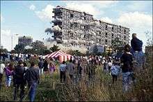
Glasgow Corporation's replacement of old, outdated and crowded housing with new high-rise towers in the 1960s did little to improve the area. The poor design and low-quality construction of the concrete, 20-storey flats led to innumerable social and health problems in the area; many of the blocks developed mould and structural problems, and the design prevented residents from visually controlling their internal and external spaces, adding to the social issues. The most infamous of the towers, the Queen Elizabeth Square flats designed by Sir Basil Spence, was demolished in 1993 to make way for a new generation of housing development.
In 2004, Glasgow Housing Association announced plans to demolish more of the decaying high-rise blocks, and to comprehensively refurbish and re-clad others. Two of the Area D blocks, as well as the entire Area E and Laurieston high-rise estates were demolished between 2002-2016. Going forward, the two surviving Area D blocks, and the entire Area B or "Riverside" estate, designed by Robert Matthew will be the only high-rise flats left in the Gorbals.
Much of the area, particularly Hutchesontown, was comprehensively redeveloped for a third time, providing a mix of private and social housing. Earlier phases of this recent redevelopment tended toward yellow-brick reinterpretations of traditional tenements, in a post-modern style. More recent phases, masterplanned by Piers Gough, have employed noted modern architects such as Page/Park, Elder & Cannon and CZWG, resulting in more bold and radical designs, accompanied by innovative street plans and high-quality landscaping. They incorporated many pieces of public art. The Gorbals Leisure Centre opened in January 2000 and the number of shopping facilities in the area is on the rise. In 2005, fire destroyed the Catholic Church of Blessed John Duns Scotus as a result of a fallen candle. The church was restored and reopened for worship in September 2010.[3]
With much of the Hutchesontown area of the Gorbals improved, the urban and social-regeneration program expanded into the neighbouring Laurieston area to the west.[4]
Since 1945, the Citizens Theatre has been based in the area at the former Royal Princess's Theatre, an historic Victorian building. The area also has a local newspaper Local News for Southsiders. The area is served by Bridge Street and West Street subway stations and numerous bus routes. Plans were unveiled in March 2007 to provide another subway station, in the heart of the redeveloped Hutchesontown.[5]
A controversial pub in the district is the Brazen Head, located at the northern end of Cathcart Road. Formerly a railway pub known as the Granite City, it is particularly associated with Irish Republicanism.[6] The pub is near the Caledonia Road Church, a derelict mid-Victorian structure designed by Alexander 'Greek' Thomson.[7]
Historical maps
A large selection of historical maps of the Gorbals is available from the National Library of Scotland.
Notable natives and residents
- Allan Pinkerton (1819–1884), who achieved fame in the United States by establishing Pinkerton's detective agency.
- Sir Thomas Lipton (1848–1931), grocery mogul, perennial America's Cup contender and founder of Lipton's Tea.
- Alexander Watson Hutton (1853-1936) was a Scottish teacher and sportsman and is considered the Father of Argentine football
- Hugh MacColl (1861–1915), founder and first captain of Spanish Sevilla F.C. in 1890, which considered to be Spain's oldest football club solely devoted to association football.
- John Maclean (1879–1923), the renowned Scottish socialist politician, stood for election in the area in the 1918 general election.
- Benny Lynch (1913–1946), boxer, became the British, European and World Flyweight Champion.
- Ralph Glasser (1916–2002) was a Scottish psychologist and economist, writer of a three-volume autobiography beginning with Growing up in the Gorbals
- Tommy Docherty (b. 1928), Scottish football player and manager (Celtic, Preston North End and Chelsea)
- Alex Harvey (1935-1982), musician
- Brothers Phil (b. 1937) and Derek Shulman (b. 1947), musicians of the 1970s British progressive rock band Gentle Giant, were born here.
- Ian Brady, the Moors murderer (b. 1938), was born in the Gorbals as Ian Duncan Stewart.
- Paddy Crerand (b. 1939), Scottish football player and MUTV pundit (Celtic and Manchester United)
- Jimmy Boyle (b. 1944), convicted criminal, novelist and sculptor
- John Martyn (b. 1948), musician
- Helena Kennedy (b. 1950), Labour member of the House of Lords
- Dame Carol Ann Duffy (b. 1955), Poet Laureate of the UK
- Michael McGurk (1958—2009), Australian businessman, murdered by a single gunshot to his head outside his Sydney family home.[8]
- Robert Millar (b. 1958), cyclist, the first and only English-speaking "King of the Mountains" champion in the Tour de France (1984)
- Lorraine Kelly (b. 1959), television presenter, journalist and actress
- Frank Bruno, the boxer, moved to the Gorbals to live with his partner in 2012.[9]
- Gerry McLauchlan (b. 1989), former Brechin City and Ayr United footballer, formerly resident of Bishopbriggs
Depictions
- The novel No Mean City (1935) is set in the Gorbals.
- The ballet Miracle in the Gorbals (1944), with choreography by Robert Helpmann and music by Arthur Bliss, is set there.
- The play The Gorbals Story (1946) by Robert McLeish is set there. Originally produced by the Glasgow Unity Theatre, it was adapted as a film by the same name released in 1950.[10]
- Poet Edwin Morgan set his poem "Glasgow Sonnet" in the Gorbals.
- Life in the Gorbals in the 1960s was documented by the photographer Oscar Marzaroli, notably in his collection Shades of Grey – Glasgow 1956-1987
- The Jeely Piece Song - A children’s' street song illustrating a profound change in the way of life in the Gorbals.
- Colin MacFarlane's autobiographical book The Real Gorbals Story: True Tales from Glasgow's Meanest Streets (Edinburgh 2007) describes growing up in the final years of the old Gorbals in the 1960s
- A scene in the promotional documentary short The Frasers' Return (1962), directed by Harvey Harrison, was shot in Gorbals council housing.
- John Buchan's novel Huntingtower (1922) was adapted in 1978 as a popular BBC TV series of the same name, featuring the Gorbals Die-Hards, which changed the setting from Carrick in southwest Scotland to Glasgow.[11]
- The novel Swing Hammer Swing! (1992) by Jeff Torrington, decades in the writing, is set in the Gorbals.
- The character Kristine Kochanski in the British TV series Red Dwarf grew up there.[12] (1997).
- The television special Blackadder's Christmas Carol refers to the Gorbals in a scene in which Prince Albert (played by Jim Broadbent) claims to be Glaswegian.
- The BBC documentary Poor Kids (2011) tells the story of a 10-year-old girl living in a mouldy, high rise council flat in the Gorbals. The high rise is demolished during the filming of the documentary.
- Top Chef Season 2 winner Ilan Hall named his first restaurant "The Gorbals" (in Los Angeles) after his immigrant Russian-Jewish father's neighbourhood in Glasgow.[13]
- In Series 3 Episode 5 of the BBC series The Thick of It, the main character Malcolm Tucker is called the "Gorbals Goebbels".
References
- 1 2 3 4 Andrew Aird (1894), Glimpses of Old Glasgow, Glasgow Digital Library, accessed 22 Oct 2010
- ↑ Smith, Ronald P A, 'The Gorbals & Oatlands - A New History, Volume 1: The Gorbals of Old', Stenlake Publishing, 2014
- ↑ Flourish (UK)
- ↑ ClydeWaterfront.com
- ↑ Evening Times (UK)
- ↑ Inside the Gorbals' hardest pub, Kenny Farquharson, the Sunday Times, 2003-09-07
- ↑ Caledonia Road United Presbyterian Church, Buildings at Risk Register for Scotland.
- ↑ Harvey, Ellie; Carson, Vanda (8 September 2009). "From a Glasgow slum to Sydney's north shore". The Sydney Morning Herald. Fairfax Media. Retrieved 22 December 2010.
- ↑ Smith, Steve; Crooks, Lauren (2012-05-06). "Boxing legend Frank Bruno stuns neighbours after moving into Glasgow flat". Daily Record. Scottish Daily Record and Sunday Mail. Retrieved 11 May 2012.
- ↑ Review: "The Gorbals Story", New York Times; accessed 14 February 2016.
- ↑ "Huntingtower", IMDB listing
- ↑ Duct Soup
- ↑ "Who", thegorbalsla.com; accessed 14 February 2016.
External links
| Wikimedia Commons has media related to Gorbals. |
- Citizens' Theatre
- Southern Necropolis Cemetery
- Gorbals Heritage Environment Trust
- Gorbals history – Clyde Waterfront Heritage
- National Library of Scotland: SCOTTISH SCREEN ARCHIVE (archive films relating to the Gorbals)
- Gorbals - Origins and History