Grade II* listed buildings in Rutland
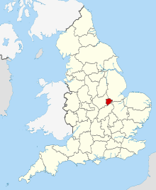
Rutland shown in England
There are over 20,000 Grade II* listed buildings in England. This page is a list of the 71 of these buildings in the county of Rutland.
Rutland
| Name | Location | Type | Completed [note 1] | Date designated | Grid ref.[note 2] Geo-coordinates |
Entry number [note 3] | Image |
|---|---|---|---|---|---|---|---|
| Church of St Mary | Ayston, Rutland | Parish Church | 13th century | 10 November 1955 | SK8594800964 52°35′59″N 0°43′57″W / 52.599679°N 0.732453°W |
1361553 |  |
| Church of St Peter | Barrowden, Rutland | Church | C13-C15 | 10 November 1955 | SP9449399906 52°35′20″N 0°36′24″W / 52.588754°N 0.606631°W |
1361433 | 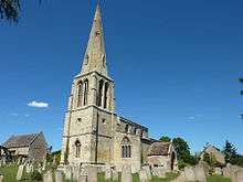 |
| Durant Farmhouse, Barn, Outhouses and Wall | Barrowden, Rutland | Farmhouse | Late C16-Early 17th century | 10 November 1955 | SK9455700071 52°35′25″N 0°36′20″W / 52.590226°N 0.60564°W |
1073957 | 
|
| Church of St Peter | Belton-in-Rutland, Rutland | Church | Early 13th century | 10 November 1955 | SK8163201349 52°36′14″N 0°47′46″W / 52.603804°N 0.796066°W |
1214903 |  |
| Old Hall | Belton-in-Rutland, Rutland | House | Late 16th century | 10 November 1955 | SK8159201365 52°36′14″N 0°47′48″W / 52.603954°N 0.796653°W |
1214952 |
|
| Westbourne House | Belton-in-Rutland, Rutland | House | Mid 18th century | 10 November 1955 | SK8157801270 52°36′11″N 0°47′49″W / 52.603102°N 0.796883°W |
1288345 |
|
| Church of All Saints | Braunston-in-Rutland, Rutland | Parish Church | 12th century | 14 June 1954 | SK8325406592 52°39′02″N 0°46′15″W / 52.65068°N 0.770803°W |
1214996 |  |
| Hall Farmhouse | Braunston-in-Rutland, Rutland | Farmhouse | Late 16th century | 14 June 1954 | SK8324606554 52°39′01″N 0°46′15″W / 52.65034°N 0.77093°W |
1215077 |
|
| Quaintree Hall | Braunston-in-Rutland, Rutland | Base Cruck House | Late 13th century | 14 June 1954 | SK8327906756 52°39′08″N 0°46′13″W / 52.652151°N 0.770392°W |
1214995 |
|
| Church of the Holy Cross | Burley, Rutland | Parish Church | Norman | 14 June 1954 | SK8830310215 52°40′57″N 0°41′43″W / 52.682444°N 0.695221°W |
1073794 |  |
| Entrance Gates and Gate Piers | Burley on the Hill, Burley, Rutland | Gate | 1700 | 18 September 1984 | SK8836410452 52°41′04″N 0°41′39″W / 52.684564°N 0.694256°W |
1177480 |
|
| Terrace Parapet, Retaining Wall and Staircase | Burley on the Hill, Burley, Rutland | Terrace | 18th century | 18 September 1984 | SK8842410152 52°40′55″N 0°41′36″W / 52.681858°N 0.693449°W |
1073793 |
|
| Church of St John | Caldecott, Rutland | Parish Church | 12th century | 10 November 1955 | SP8684093691 52°32′03″N 0°43′16″W / 52.534171°N 0.72119°W |
1116288 |  |
| Church of St Mary | Clipsham, Rutland | Church | 12th century | 6 June 1961 | SK9701816363 52°44′10″N 0°33′52″W / 52.736206°N 0.564535°W |
1361803 |  |
| Clipsham Hall | Clipsham, Rutland | Country House | c. 1700 | 6 June 1961 | SK9703516435 52°44′13″N 0°33′51″W / 52.73685°N 0.564262°W |
1073244 |  |
| Manor Farmhouse and Outbuilding Range | Clipsham, Rutland | Farmhouse | Late C16-C17 | 6 June 1961 | SK9706216172 52°44′04″N 0°33′50″W / 52.734482°N 0.56394°W |
1361766 |
|
| Church of St Nicholas | Cottesmore, Rutland | Church | C12-C15 | 14 June 1954 | SK9024913637 52°42′46″N 0°39′56″W / 52.712878°N 0.665506°W |
1073252 |  |
| Thor Missile Site at former RAF North Luffenham | Edith Weston, Rutland | Thor Missile Site | 20th century | 17 June 2011 | SK9504404596 52°37′51″N 0°35′50″W / 52.630807°N 0.597154°W |
1400806 |
|
| Old Prebendal House | Empingham, Rutland | Clergy House | Late 17th century | 14 June 1954 | SK9514108468 52°39′56″N 0°35′41″W / 52.665588°N 0.594606°W |
1361456 |
|
| Church of St Mary | Essendine, Rutland | Church | 12th century | 6 June 1961 | TF0490212789 52°42′09″N 0°26′56″W / 52.702619°N 0.448952°W |
1073881 |  |
| Church of St Andrew | Glaston, Rutland | Parish Church | 12th century | 10 November 1955 | SK8963200552 52°35′43″N 0°40′41″W / 52.595382°N 0.678188°W |
1264584 |  |
| Church of St Andrew | Hambleton, Rutland | Parish Church | Norman | 14 June 1954 | SK8997207581 52°39′31″N 0°40′17″W / 52.658498°N 0.671258°W |
1073753 |  |
| Old Hall, Gate Piers and Flanking Wall | Hambleton, Rutland | House | c. 1611 | 14 June 1954 | SK8991106949 52°39′10″N 0°40′20″W / 52.652828°N 0.672332°W |
1295255 |
|
| Fort Henry Pleasure House and Flanking Retaining Walls and Parapet | Exton Park, Horn, Rutland | Wall | Late 18th century | 10 December 1981 | SK9486212169 52°41′56″N 0°35′52″W / 52.698897°N 0.597666°W |
1073724 |  |
| The Priory | Ketton, Rutland | House | 17th century | 6 June 1961 | SK9820404273 52°37′38″N 0°33′02″W / 52.627343°N 0.550577°W |
1361471 |
|
| Old Hall | Langham, Rutland | Hall House | 1665 | 14 June 1954 | SK8447611154 52°41′29″N 0°45′06″W / 52.691493°N 0.751576°W |
1295196 |
|
| Church of All Saints | Little Casterton, Rutland | Church | Earlier origin | 6 June 1961 | TF0180509909 52°40′38″N 0°29′44″W / 52.677329°N 0.495658°W |
1361524 |  |
| Tolethorpe Hall | Tolethorpe, Little Casterton, Rutland | Country House | Late 16th century or early 17th century | 6 June 1961 | TF0219410342 52°40′52″N 0°29′23″W / 52.681147°N 0.489773°W |
1073802 |  |
| Church of St Martin | Lyndon, Rutland | Church | C13-14 | 14 June 1954 | SK9073304421 52°37′48″N 0°39′39″W / 52.629971°N 0.660878°W |
1177703 |  |
| Lyndon Hall | Lyndon, Rutland | Country House | 1671-3 | 14 June 1954 | SK9069904363 52°37′46″N 0°39′41″W / 52.629456°N 0.661396°W |
1361483 |
|
| Top Hall | Lyndon, Rutland | House | Late 17th century | 14 June 1954 | SK9072504783 52°38′00″N 0°39′39″W / 52.633226°N 0.660897°W |
1361485 |
|
| Church of St Mary | Manton, Rutland | Parish Church | Late 12th century | 14 June 1954 | SK8807004677 52°37′58″N 0°42′01″W / 52.63271°N 0.700144°W |
1215415 |  |
| Barn at Luffenham Hall | North Luffenham, Rutland | Barn | 1555 | 10 November 1955 | SK9354203260 52°37′09″N 0°37′11″W / 52.619061°N 0.619717°W |
1073900 |
|
| Bede House Farmhouse | North Luffenham, Rutland | House | Early 15th century | 29 June 1984 | SK9328003418 52°37′14″N 0°37′25″W / 52.620526°N 0.623541°W |
1073865 |
|
| Manor Farmhouse | North Luffenham, Rutland | Farmhouse | 1640 | 10 November 1955 | SK9324903464 52°37′15″N 0°37′26″W / 52.620945°N 0.623986°W |
1073863 |
|
| The Pastures | North Luffenham, Rutland | House | 1901 | 29 June 1984 | SK9310303405 52°37′14″N 0°37′34″W / 52.62044°N 0.626159°W |
1361473 |
|
| Chapel of the Hospitallers of St John the Evangelist and St Anne | Oakham, Rutland | Chapel | c. 1380 | 8 May 1950 | SK8573208719 52°40′10″N 0°44′01″W / 52.669411°N 0.733631°W |
1073262 |
|
| College House Sanatorium at Oakham School | Oakham, Rutland | Vicarage | c. 1330 | 8 May 1950 | SK8601708842 52°40′14″N 0°43′46″W / 52.670472°N 0.729385°W |
1073308 |
|
| Flores House | Oakham, Rutland | House | 13th century OR 14th century | 8 May 1950 | SK8603508742 52°40′10″N 0°43′45″W / 52.66957°N 0.729145°W |
1073313 |
|
| Hayne House | Oakham, Rutland | House | Early 18th century | 8 May 1950 | SK8571508863 52°40′15″N 0°44′02″W / 52.670708°N 0.733845°W |
1073287 |
|
| Judge's Lodging | Oakham, Rutland | House | Early 17th century | 8 May 1950 | SK8624808646 52°40′07″N 0°43′34″W / 52.668674°N 0.726022°W |
1361755 |
|
| Old Grammar School the Shakespeare Centre | Oakham, Rutland | Grammar School | 1584 | 8 May 1950 | SK8611208967 52°40′18″N 0°43′41″W / 52.67158°N 0.727948°W |
1073309 |  |
| Church of St Nicholas | Pilton, Rutland | Parish Church | PERPENDICULAR AND EARLIER | 10 November 1955 | SK9146602932 52°36′59″N 0°39′02″W / 52.616466°N 0.650463°W |
1215644 |
|
| Church of St Peter and St Paul | Preston, Rutland | Parish Church | LATE C12/EARLY 13th century | 10 November 1955 | SK8700802371 52°36′44″N 0°42′59″W / 52.612156°N 0.716438°W |
1361558 |  |
| Manor House | Preston, Rutland | House | Mid 16th century | 10 November 1955 | SK8719002456 52°36′46″N 0°42′49″W / 52.612891°N 0.713728°W |
1178203 |
|
| 2 Cross Lane | Preston, Rutland | House | Late 17th century | 10 November 1955 | SK8716602428 52°36′46″N 0°42′51″W / 52.612643°N 0.71409°W |
1295182 |
|
| The Hall | Ryhall, Rutland | House | Medieval | 6 June 1961 | TF0360810783 52°41′05″N 0°28′07″W / 52.684841°N 0.468726°W |
1361527 |
|
| Church of St Mary | South Luffenham, Rutland | Church | C12-C14 | 10 November 1955 | SK9413301899 52°36′24″N 0°36′41″W / 52.606728°N 0.611377°W |
1073877 |  |
| South Luffenham Hall | South Luffenham, Rutland | Country House | Late 17th century | 10 November 1955 | SK9422601857 52°36′23″N 0°36′36″W / 52.606334°N 0.610016°W |
1073873 |
|
| Church of St Nicholas | Stretton, Rutland | Church | C12-C14 | 14 June 1954 | SK9497315769 52°43′52″N 0°35′42″W / 52.731231°N 0.594985°W |
1361819 |  |
| Stocken Hall | Stretton, Rutland | Country House | Early 17th century | 14 September 1979 | SK9571918171 52°45′10″N 0°35′00″W / 52.752686°N 0.583241°W |
1073203 |  |
| Church of Holy Trinity | Teigh, Rutland | Church | 13th century | 14 June 1954 | SK8648616012 52°44′05″N 0°43′14″W / 52.734837°N 0.720569°W |
1361821 |  |
| Old Rectory | Teigh, Rutland | House | 1740 | 14 June 1954 | SK8652316019 52°44′06″N 0°43′12″W / 52.734894°N 0.720019°W |
1073204 | 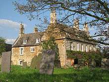 |
| Church of St Nicholas | Thistleton, Rutland | Church | 14th century | 14 June 1954 | SK9133617976 52°45′06″N 0°38′54″W / 52.751691°N 0.648215°W |
1177828 | 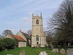 |
| Manor House | Thorpe by Water, Rutland | House | 1691 | 10 November 1955 | SP8930396457 52°33′31″N 0°41′03″W / 52.558632°N 0.684146°W |
1237065 |
|
| The Old Manor House | Thorpe by Water, Rutland | House | C1600-c1700 | 10 November 1955 | SP8932696491 52°33′32″N 0°41′02″W / 52.558934°N 0.683797°W |
1237181 |
|
| Church of All Saints | Tinwell, Rutland | Church | 13th century | 6 June 1961 | TF0061206369 52°38′45″N 0°30′52″W / 52.645738°N 0.514376°W |
1320402 |  |
| Wall and Water Point East of Post Office, Number 26 and Number 27 | Tinwell, Rutland | Garden Wall | 1880 | 17 December 1984 | TF0054206389 52°38′45″N 0°30′55″W / 52.645931°N 0.515404°W |
1073782 |  |
| Church of St Luke/St Mary Magdalen | Tixover, Rutland | Church | C12-C17 | 6 June 1961 | SP9707899767 52°35′13″N 0°34′07″W / 52.58705°N 0.568528°W |
1178264 | Aug2006.jpg) |
| Church of St Peter and St Paul | Uppingham, Rutland | Parish Church | 14th century | 10 November 1955 | SP8667299606 52°35′14″N 0°43′20″W / 52.587359°N 0.722122°W |
1073973 |  |
| Falcon Hotel Annexe Jt Backus Murray | Uppingham, Rutland | House | late C16-early 17th century | 10 November 1955 | SP8664599694 52°35′17″N 0°43′21″W / 52.588154°N 0.722497°W |
1073181 |
|
| The Hall | Uppingham, Rutland | House | 1612 | 10 November 1955 | SP8684799610 52°35′15″N 0°43′10″W / 52.587367°N 0.719539°W |
1295156 |
|
| Uppingham Bookshop and the Sports Shop | Uppingham, Rutland | House | C16-C17 | 10 November 1955 | SP8667499691 52°35′17″N 0°43′19″W / 52.588123°N 0.72207°W |
1073182 |
|
| Uppingham School Chapel | Uppingham, Rutland | Chapel | 1865 | 10 November 1955 | SP8650499620 52°35′15″N 0°43′29″W / 52.587512°N 0.724597°W |
1073175 |
|
| Uppingham School Library | Uppingham, Rutland | School | c. 1890 | 10 November 1955 | SP8655299594 52°35′14″N 0°43′26″W / 52.58727°N 0.723896°W |
1073172 |
|
| Uppingham School School Room | Uppingham, Rutland | Schoolroom | 1861-3 | 10 November 1955 | SP8649399643 52°35′16″N 0°43′29″W / 52.58772°N 0.724754°W |
1073176 |  |
| 8 High Street West | Uppingham, Rutland | House | late C16-C17 | 10 November 1955 | SP8656799695 52°35′17″N 0°43′25″W / 52.588176°N 0.723648°W |
1295140 |
|
| Church of St Botolph | Wardley, Rutland | Parish Church | Early 13th century | 10 November 1955 | SK8319200193 52°35′35″N 0°46′24″W / 52.593178°N 0.773328°W |
1180127 |  |
| The Windmill | Whissendine, Rutland | Flour Mill | 1830-1840 | 4 February 1972 | SK8235614242 52°43′10″N 0°46′56″W / 52.719573°N 0.782162°W |
1073211 |  |
| Church of St Michael | Whitwell, Rutland | Parish Church | 13th century | 14 June 1954 | SK9236508804 52°40′09″N 0°38′08″W / 52.669087°N 0.635548°W |
1295155 | 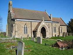 |
| Church of St Peter and St Paul | Wing, Rutland | Parish Church | Medieval | 10 November 1955 | SK8937202979 52°37′02″N 0°40′53″W / 52.617237°N 0.68137°W |
1215836 | |
See also
Notes
- ↑ The date given is the date used by Historic England as significant for the initial building or that of an important part in the structure's description.
- ↑ Sometimes known as OSGB36, the grid reference is based on the British national grid reference system used by the Ordnance Survey.
- ↑ The "List Entry Number" is a unique number assigned to each listed building and scheduled monument by Historic England.
References
English Heritage Images of England
External links
![]() Media related to Grade II* listed buildings in Rutland at Wikimedia Commons
Media related to Grade II* listed buildings in Rutland at Wikimedia Commons
This article is issued from Wikipedia - version of the 8/28/2016. The text is available under the Creative Commons Attribution/Share Alike but additional terms may apply for the media files.