Grade II* listed buildings in Sevenoaks District
There are over 20,000 Grade II* listed buildings in England. This page is a list of these buildings in the district of Sevenoaks in Kent.
Sevenoaks
| Name | Location | Type | Completed [note 1] | Date designated | Grid ref.[note 2] Geo-coordinates |
Entry number [note 3] | Image |
|---|---|---|---|---|---|---|---|
| Ash Manor | New Ash Green, Ash-cum-Ridley, Sevenoaks | House | Early 17th century | 1 August 1952 | TQ6021464541 51°21′26″N 0°17′59″E / 51.357353°N 0.29964°E |
1216772 | 
|
| Church of Saint Peter | Ridley, Ash-cum-Ridley | Church | 13th century | 1 June 1967 | TQ6161463901 51°21′04″N 0°19′10″E / 51.351206°N 0.319439°E |
1216987 | .jpg) |
| South Ash Manor | Ash-cum-Ridley | House | Later | 1 June 1967 | TQ5959863165 51°20′43″N 0°17′25″E / 51.345163°N 0.290184°E |
1275615 |
|
| Church of St Martin | Brasted | Church | 13th century | 10 September 1954 | TQ4686155490 51°16′47″N 0°06′15″E / 51.279629°N 0.104282°E |
1346417 | 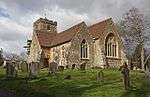 |
| The walled garden at Chevening House including potting range | Chevening House, Chevening | Walled Garden | c. 1775 | 14 July 1988 | TQ4837957803 51°18′00″N 0°07′37″E / 51.30002°N 0.126991°E |
1244220 |
|
| Bee house in walled garden at Chevening House | Chevening House, Chevening | Apiary | c. 1850 | 14 July 1988 | TQ4834057740 51°17′58″N 0°07′35″E / 51.299464°N 0.126406°E |
1244221 |
|
| Chiddingstone Castle | Chiddingstone Castle, Chiddingstone | House | 17th century | 16 January 1975 | TQ4983145126 51°11′09″N 0°08′33″E / 51.18573°N 0.142503°E |
1252483 | 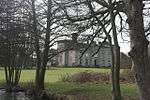 |
| Church of St Luke | Chiddingstone Causeway, Chiddingstone | Church | 1897-98 | 10 September 1954 | TQ5169546664 51°11′57″N 0°10′11″E / 51.199059°N 0.169803°E |
1252482 |  |
| Church of St Mary | Chiddingstone | Church | 1627 | 10 September 1954 | TQ5008645193 51°11′11″N 0°08′46″E / 51.186265°N 0.146177°E |
1262259 | 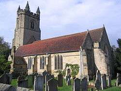 |
| Prinkham | Prinkham, Chiddingstone | House | Early 17th century | 10 September 1954 | TQ4957941132 51°09′00″N 0°08′14″E / 51.149907°N 0.13724°E |
1085873 | 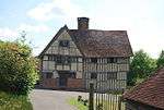 |
| Pumphouse Gazebo Orangery and Garden Wall Chiddingstone Castle | Chiddingstone Castle, Chiddingstone | Garden Wall | c. 1797 | 16 January 1975 | TQ4978345062 51°11′07″N 0°08′30″E / 51.185168°N 0.14179°E |
1085889 |
|
| The Castle Inn | Chiddingstone | Inn | 16th century | 10 September 1954 | TQ5004245153 51°11′09″N 0°08′44″E / 51.185917°N 0.145531°E |
1252477 | _-_geograph.org.uk_-_1260236.jpg) |
| The Post Office and Village Shop | Chiddingstone | Jettied House | 16th century | 10 September 1954 | TQ5008745157 51°11′09″N 0°08′46″E / 51.185942°N 0.146176°E |
1252475 | 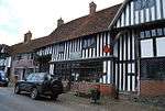 |
| Woodgates | Chiddingstone Hoath, Chiddingstone | House | 16th century | 16 January 1975 | TQ5012042345 51°09′38″N 0°08′44″E / 51.160665°N 0.145475°E |
1336423 |
|
| 1 High Street | Chiddingstone | Jettied House | 16th century | 10 September 1954 | TQ5010945158 51°11′09″N 0°08′47″E / 51.185945°N 0.146491°E |
1252472 | 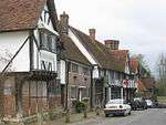 |
| 4 High Street | Chiddingstone | House | 1697 | 10 September 1954 | TQ5007045156 51°11′09″N 0°08′45″E / 51.185937°N 0.145932°E |
1085885 | |
| Bassets Farmhouse | Bassets Farm, Cowden | Farmhouse | Early 16th century | 10 September 1954 | TQ4954641304 51°09′05″N 0°08′13″E / 51.151461°N 0.13684°E |
1252534 | 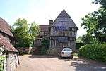 |
| Crippenden Manor House | Crippenden Manor, Cowden | Manor House | 1607 | 10 September 1954 | TQ4471541736 51°09′24″N 0°04′05″E / 51.156584°N 0.067988°E |
1253834 | 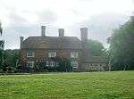 |
| Waystrode Manor | Waystrode Manor, Cowden | Farmhouse | 15th century | 10 September 1954 | TQ4599240584 51°08′45″N 0°05′09″E / 51.145908°N 0.085769°E |
1336397 |  |
| Broughton House | Broughton House, Dunton Green | Villa | c. 1830 | 10 September 1954 | TQ5116458125 51°18′08″N 0°10′01″E / 51.302181°N 0.167045°E |
1253962 |
|
| Fort Halstead: Buildings F16 and F17 | Dunton Green | Bomb Chamber | Built in 1947 | 21 March 2013 | TQ4991459168 51°18′43″N 0°08′58″E / 51.311883°N 0.149566°E |
1412293 |
|
| Church House | Edenbridge | Farmhouse | 1378-1396 | 10 September 1954 | TQ4438046138 51°11′46″N 0°03′54″E / 51.196226°N 0.064968°E |
1242994 |
|
| Old Stanford's End | Stanford's End, Edenbridge | Farmhouse | 15th century | 10 September 1954 | TQ4508444460 51°10′51″N 0°04′28″E / 51.180969°N 0.074359°E |
1258231 |
|
| Tanyard House | Edenbridge, Edenbridge | House | Later-Post 15th century | 10 September 1954 | TQ4439446048 51°11′43″N 0°03′54″E / 51.195413°N 0.065132°E |
1258054 |
|
| Taylour House | Edenbridge | House | Later-Post 15th century | 10 September 1954 | TQ4440346112 51°11′46″N 0°03′55″E / 51.195986°N 0.065286°E |
1085940 |
|
| The Crown Hotel | Edenbridge | House | Later-Post 15th century | 10 September 1954 | TQ4438646117 51°11′46″N 0°03′54″E / 51.196036°N 0.065045°E |
1259794 |  |
| Lullingstone Castle | Lullingstone, Eynsford | House | 1543-1580 | 1 August 1952 | TQ5301264382 51°21′28″N 0°11′46″E / 51.357908°N 0.196219°E |
1222202 | 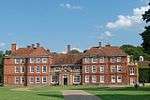 |
| Mausoleum of Thomas Nash in churchyard of Saint Peter and Saint Paul to the south of porch | Farningham | Mausoleum | c. 1778 | 22 October 1982 | TQ5471666879 51°22′48″N 0°13′18″E / 51.379882°N 0.221759°E |
1237803 | 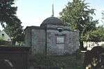 |
| Mill House | Farningham | House | c. 1790 | 1 August 1952 | TQ5451066993 51°22′51″N 0°13′08″E / 51.380962°N 0.21885°E |
1274483 |  |
| The Water Mill | Farningham | Watermill | c1790 and before 1799 | 1 August 1952 | TQ5450467008 51°22′52″N 0°13′08″E / 51.381099°N 0.218771°E |
1238035 | |
| The White House | Farningham | House | c. 1743 | 1 June 1967 | TQ5455767104 51°22′55″N 0°13′10″E / 51.381947°N 0.219573°E |
1274501 |
|
| The Parish Church of Saint Mary the Virgin | Horton Kirby and South Darenth | Church | c. 1190 | 1 June 1967 | TQ5620968559 51°23′40″N 0°14′38″E / 51.394568°N 0.243933°E |
1238792 | .jpg) |
| Church of St Mary | Kemsing | Church | Possibly 16th century | 10 September 1954 | TQ5560858784 51°18′25″N 0°13′52″E / 51.306906°N 0.23103°E |
1258355 |  |
| Crowdleham | Crowdleham, Kemsing | House | Early 19th century | 10 September 1954 | TQ5674158880 51°18′27″N 0°14′50″E / 51.307458°N 0.247313°E |
1258570 |
|
| Walnut Tree Cottage | Heaverham, Kemsing | House | Probably 16th century | 10 September 1954 | TQ5708358769 51°18′23″N 0°15′08″E / 51.306366°N 0.252167°E |
1258569 |
|
| Church of St Katherine | Knockholt | Church | Medieval | 22 October 1971 | TQ4678258929 51°18′38″N 0°06′16″E / 51.310552°N 0.104563°E |
1273386 | .jpg) |
| Church of St Mary | Leigh | Church | 13th century | 10 September 1954 | TQ5487246608 51°11′52″N 0°12′55″E / 51.197704°N 0.215215°E |
1258950 | 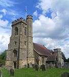 |
| Paul's Farmhouse | Paul's Farm, Leigh | Farmhouse | 16th century or earlier | 10 September 1954 | TQ5445246130 51°11′37″N 0°12′32″E / 51.193522°N 0.209003°E |
1258824 | 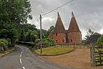 |
| Ramhurst Manor House | Ramhurst Manor, Leigh | Manor House | 16th century or earlier | 10 September 1954 | TQ5638746705 51°11′53″N 0°14′13″E / 51.198163°N 0.236923°E |
1258987 | 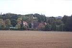 |
| Broughton Manor | Otford | House | 17th century | 10 September 1954 | TQ5228559270 51°18′44″N 0°11′01″E / 51.312171°N 0.183602°E |
1259018 | 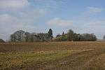 |
| Castle Cottages and Store Building at East End | Otford | Archbishops Palace | Early 16th century | 10 September 1954 | TQ5283059199 51°18′41″N 0°11′29″E / 51.311387°N 0.191385°E |
1273146 |
|
| Holmesdale House & Holmesdale Villa | Otford | House | Early 18th century | 10 September 1954 | TQ5277059258 51°18′43″N 0°11′26″E / 51.311933°N 0.19055°E |
1259052 |
|
| Pickmoss including Former No 67 (Pickmoss Cottage) | Otford | House | Later-Post c1700 | 10 September 1954 | TQ5241159338 51°18′46″N 0°11′08″E / 51.312748°N 0.185437°E |
1259016 |
|
| The Chantry House | Otford | House | c. 1540 | 16 January 1975 | TQ5282259295 51°18′44″N 0°11′29″E / 51.312252°N 0.191311°E |
1273144 |  |
| Wall and Gates to North of Broughton Manor | Otford | Gate | 17th century | 16 January 1975 | TQ5231259305 51°18′45″N 0°11′02″E / 51.312478°N 0.184004°E |
1259019 |
|
| Brick Barn to West and slightly North of Chafford Park | Chafford Park, Penshurst | Barn | Possibly 16th century | 16 January 1975 | TQ5158439510 51°08′05″N 0°09′55″E / 51.134805°N 0.165202°E |
1243038 |
|
| Cartshed adjoining Road to North of South Park Farmhouse | South Park, Penshurst | Cart Shed | 1850-1 | 16 January 1975 | TQ5232242698 51°09′48″N 0°10′38″E / 51.163256°N 0.17709°E |
1243096 |
|
| Chafford Park | Chafford Park, Penshurst | House | Early 18th century | 10 September 1954 | TQ5162639478 51°08′04″N 0°09′57″E / 51.134507°N 0.165789°E |
1243036 | 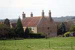 |
| Garden wall to north, east and south of Penshurst Place Gardens | Penshurst Park, Penshurst, Sevenoaks | Gate | 1739 | 10 September 1954 | TQ5294344034 51°10′30″N 0°11′12″E / 51.175095°N 0.186533°E |
1243045 |
|
| Inner garden wall to north and west of formal garden of Penshurst Place | Penshurst Park, Penshurst | Wall | Probably Early 17th century | 16 January 1975 | TQ5274443909 51°10′26″N 0°11′01″E / 51.174025°N 0.183635°E |
1273071 |
|
| Old Swaylands incorporating the Former Swale Cottage | Old Swaylands, Penshurst | House | 16th century | 10 September 1954 | TQ5341042594 51°09′43″N 0°11′33″E / 51.162031°N 0.192594°E |
1273095 | 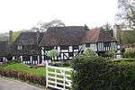 |
| Range of Farm Buildings at West End of South Park Farmyard | South Park, Penshurst | Steam Engine House | 17th century | 16 January 1975 | TQ5226942711 51°09′48″N 0°10′35″E / 51.163386°N 0.176338°E |
1243027 |
|
| South Park Farmhouse including attached Barn | South Park, Penshurst | Farmhouse | 16th century | 16 January 1975 | TQ5230642680 51°09′47″N 0°10′37″E / 51.163098°N 0.176854°E |
1243092 |
|
| Springhill | Fordcombe, Penshurst | Farmhouse | 16th century | 10 September 1954 | TQ5227940917 51°08′50″N 0°10′33″E / 51.147264°N 0.175723°E |
1243121 |
|
| Star House including Boutique | Penshurst | House | 19th century | 10 September 1954 | TQ5250143570 51°10′16″N 0°10′48″E / 51.171043°N 0.180018°E |
1243221 |  |
| The Old Guildhouse | Penshurst | House | Later,Post 16th century | 16 January 1975 | TQ5275143824 51°10′24″N 0°11′01″E / 51.173259°N 0.183699°E |
1272985 | 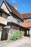 |
| Wall running south south east from southern tip of Penshurst Place and returning eastward | Penshurst Park, Penshurst | Boundary Wall | 17th century | 10 September 1954 | TQ5275643872 51°10′25″N 0°11′02″E / 51.173689°N 0.183791°E |
1243174 |
|
| Western Cartshed to North of South Park Farmhouse | South Park, Penshurst | Cart Shed | 1850-1 | 16 January 1975 | TQ5231242699 51°09′48″N 0°10′37″E / 51.163267°N 0.176948°E |
1272451 |
|
| Black Charles | Underriver, Seal | House | Later 16th century | 10 September 1954 | TQ5552252410 51°14′59″N 0°13′37″E / 51.249659°N 0.227025°E |
1243688 | 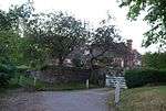 |
| Catts Cottage | Underriver, Seal | Farmhouse | Late Medieval | 10 September 1954 | TQ5569452114 51°14′49″N 0°13′46″E / 51.246952°N 0.229359°E |
1272772 |
|
| Stonepitts Manor House | Stonepitts, Seal, Sevenoaks | House | Possibly 14th century or Early 15th century | 10 September 1954 | TQ5686557051 51°17′28″N 0°14′54″E / 51.29099°N 0.248288°E |
1243513 |
|
| Almshouses | Sevenoaks | Gate | 18th century | 13 April 1951 | TQ5314654151 51°15′57″N 0°11′38″E / 51.265945°N 0.193752°E |
1086007 | 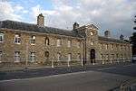 |
| Archway connecting to the Almshouses | Sevenoaks | Gate | Dated 1890 | 13 April 1951 | TQ5316454201 51°15′59″N 0°11′39″E / 51.266389°N 0.194032°E |
1204196 |
|
| Bradbourne Farmhouse | Bradbourne Farm, Sevenoaks | Farmhouse | c. 1700 | 13 April 1951 | TQ5223656377 51°17′10″N 0°10′54″E / 51.28619°N 0.181666°E |
1086043 |
|
| Chantry House including Entrance Gateway and Screen Wall to Courtyard | Sevenoaks | House | 17th century | 13 April 1951 | TQ5313054267 51°16′01″N 0°11′37″E / 51.266991°N 0.193573°E |
1086021 |  |
| Church of Saint Nicholas | Sevenoaks | Parish Church | 13th century | 13 April 1951 | TQ5311754311 51°16′03″N 0°11′36″E / 51.26739°N 0.193405°E |
1204351 |  |
| Sevenoaks School | Sevenoaks | School | Early 18th century | 13 April 1951 | TQ5316854189 51°15′59″N 0°11′39″E / 51.26628°N 0.194084°E |
1336360 | .jpg) |
| Side Screen Walls connecting the Almshouses | Sevenoaks | Wall | Early 18th century | 13 April 1951 | TQ5315854204 51°15′59″N 0°11′38″E / 51.266418°N 0.193947°E |
1204209 |
|
| The Old House | Sevenoaks | House | c. 1700 | 13 April 1951 | TQ5315954372 51°16′05″N 0°11′39″E / 51.267927°N 0.194033°E |
1204256 |
|
| The Red House including Entrance Gateway, Railings and Side Brick Walls to Forecourt | Sevenoaks | House | c. 1700 | 13 April 1951 | TQ5312854518 51°16′09″N 0°11′37″E / 51.269247°N 0.193652°E |
1204275 | 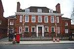 |
| 13 High Street | Sevenoaks | House | 16th century | 13 April 1951 | TQ5312254215 51°15′59″N 0°11′36″E / 51.266526°N 0.193436°E |
1086019 |
|
| 15 High Street | Sevenoaks | House | 16th century | 13 April 1951 | TQ5312054224 51°16′00″N 0°11′36″E / 51.266608°N 0.193411°E |
1204347 |
|
| 17 High Street | Sevenoaks | House | 16th century | 13 April 1951 | TQ5312654231 51°16′00″N 0°11′37″E / 51.266669°N 0.1935°E |
1086020 |
|
| Long Barn | Sevenoaks Weald | House | 16th century | 10 September 1954 | TQ5264150571 51°14′02″N 0°11′06″E / 51.233913°N 0.184994°E |
1272861 |
|
| Wickhurst Manor | Wickhurst Manor, Sevenoaks Weald | House | 19th century | 10 September 1954 | TQ5173751249 51°14′25″N 0°10′20″E / 51.240246°N 0.172342°E |
1272858 |  |
| Filston Hall Farmhouse | Filstone Hall Farm, Shoreham | Farmhouse | Late Medieval | 10 September 1954 | TQ5160560778 51°19′33″N 0°10′28″E / 51.325902°N 0.174493°E |
1243841 | 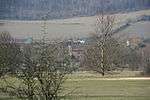 |
| Church of St Mary at South End of Village Green | Ide Hill, Sundridge with Ide Hill | Church | 1865-6 | 10 September 1954 | TQ4861651698 51°14′42″N 0°07′40″E / 51.245101°N 0.127852°E |
1272747 | 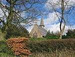 |
| The Old Hall | Sundridge, Sundridge with Ide Hill | House | 15th century | 10 September 1954 | TQ4802555326 51°16′40″N 0°07′15″E / 51.277855°N 0.120891°E |
1243928 |
|
| The Old Rectory | Sundridge, Sundridge with Ide Hill | House | 18th century | 10 September 1954 | TQ4852255231 51°16′37″N 0°07′41″E / 51.276872°N 0.127972°E |
1243893 | 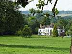 |
| Yorkshill Farmhouse | Yorkshill, Sundridge with Ide Hill | Farmhouse | 15th century or earlier | 16 January 1975 | TQ4986651353 51°14′30″N 0°08′44″E / 51.241674°N 0.145603°E |
1243929 |
|
| Church of St Mary the Virgin | Westerham | Church | 13th century | 10 September 1954 | TQ4475954083 51°16′03″N 0°04′25″E / 51.267524°N 0.073596°E |
1244024 | .jpg) |
| Court Lodge | Westerham | House | 17th century | 10 September 1954 | TQ4464054637 51°16′21″N 0°04′20″E / 51.272532°N 0.072115°E |
1272576 |  |
| Crockham House | Crockham House, Westerham | House | 17th century | 10 September 1954 | TQ4461752030 51°14′57″N 0°04′15″E / 51.249111°N 0.070732°E |
1272646 |
|
| Darenth Cottage | Westerham | House | 15th century | 10 September 1954 | TQ4487154046 51°16′02″N 0°04′31″E / 51.267163°N 0.075185°E |
1244137 |
|
| Farley & Wolfelands | Westerham | Apartments | Late 17th century | 10 September 1954 | TQ4403753683 51°15′51″N 0°03′47″E / 51.264112°N 0.063093°E |
1272571 |
|
| Grosvenor House | Westerham | House | Early 18th century | 10 September 1954 | TQ4488254014 51°16′01″N 0°04′31″E / 51.266872°N 0.07533°E |
1244143 |
|
| Rysted House | Westerham | House | 1675 | 10 September 1954 | TQ4444353970 51°16′00″N 0°04′08″E / 51.266588°N 0.069024°E |
1244079 |
|
| Squerryes Lodge | Westerham | House | Late 17th century | 10 September 1954 | TQ4459853890 51°15′57″N 0°04′16″E / 51.26583°N 0.071212°E |
1244038 |
|
| Statue of General Wolfe | Westerham | Statue | 1911 | 10 September 1954 | TQ4466854028 51°16′01″N 0°04′20″E / 51.267053°N 0.07227°E |
1244025 | 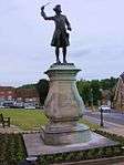 |
| The Vicarage and Vicarage Flat above | Westerham | Apartment | Later-Post 15th century | 10 September 1954 | TQ4477553979 51°16′00″N 0°04′26″E / 51.266585°N 0.073783°E |
1244140 |
|
| 49 and 51 High Street | Westerham | House | 1600 | 10 September 1954 | TQ4441053884 51°15′57″N 0°04′07″E / 51.265824°N 0.068516°E |
1272573 | |
Notes
- ↑ The date given is the date used by Historic England as significant for the initial building or that of an important part in the structure's description.
- ↑ Sometimes known as OSGB36, the grid reference is based on the British national grid reference system used by the Ordnance Survey.
- ↑ The "List Entry Number" is a unique number assigned to each listed building and scheduled monument by Historic England.
External links
![]() Media related to Grade II* listed buildings in Kent at Wikimedia Commons
Media related to Grade II* listed buildings in Kent at Wikimedia Commons
This article is issued from Wikipedia - version of the 8/31/2016. The text is available under the Creative Commons Attribution/Share Alike but additional terms may apply for the media files.