Grade II* listed buildings in Warwick (district)
There are over 20,000 Grade II* listed buildings in England. This page is a list of these buildings in the district of Warwick in Warwickshire.
Warwick
| Name | Location | Type | Completed [note 1] | Date designated | Grid ref.[note 2] Geo-coordinates |
Entry number [note 3] | Image |
|---|---|---|---|---|---|---|---|
| Church of St Michael | Baddesley Clinton, Warwick | Church | 13th century | 11 April 1967 | SP2026071359 52°20′24″N 1°42′15″W / 52.339941°N 1.704056°W |
1035101 | 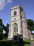 |
| Barford House | Barford, Warwick | Country House | c. 1820 | 11 April 1967 | SP2701360532 52°14′32″N 1°36′21″W / 52.242316°N 1.605805°W |
1035249 |  |
| Church of St Peter | Barford, Warwick | Parish Church | Late 14th century | 11 April 1967 | SP2723460909 52°14′44″N 1°36′09″W / 52.245694°N 1.602538°W |
1116437 | .jpg) |
| Abbey Ruins approximately 10 Metres South of Church of St Leonard | Wroxall, Beausale, Haseley, Honiley and Wroxall, Warwick | Chapter House | c. 1135 | 11 April 1967 | SP2219970708 52°20′02″N 1°40′32″W / 52.334013°N 1.67564°W |
1365012 | 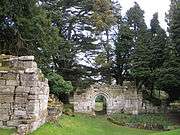 |
| Abbey Ruins approximately 15 Metres South of Church of St Leonard | Wroxall, Beausale, Haseley, Honiley and Wroxall, Warwick | Abbey | c. 1135 | 11 April 1967 | SP2217170698 52°20′02″N 1°40′34″W / 52.333925°N 1.676051°W |
1300031 | 
|
| Church Gate Piers West of Church of St John | Honiley, Beausale, Haseley, Honiley and Wroxall, Warwick | Gate Pier | c. 1723 | 23 January 1987 | SP2442072225 52°20′51″N 1°38′35″W / 52.347557°N 1.642936°W |
1035213 |  |
| The Hunting Lodge | Castle Park, Bishop's Tachbrook, Warwick | House | 1748 | 6 November 1979 | SP2936763010 52°15′52″N 1°34′16″W / 52.264473°N 1.571116°W |
1035221 |
|
| Church of St Charles (Roman Catholic) | Hampton on the Hill, Budbrooke, Warwick | Church | 1819 | 23 January 1987 | SP2524564320 52°16′35″N 1°37′53″W / 52.276454°N 1.631416°W |
1115663 |  |
| Church of Holy Trinity | Hatton Green, Hatton, Warwick | Parish Church | 15th century | 11 April 1967 | SP2360267368 52°18′14″N 1°39′19″W / 52.303928°N 1.655283°W |
1035212 | .jpg) |
| The Old Vicarage | Hatton Green, Hatton, Warwick | House | Mid 18th century | 11 April 1967 | SP2323967555 52°18′20″N 1°39′38″W / 52.305625°N 1.660594°W |
1035208 |
|
| Hunningham Railway Bridge | Marton Junction, Hunningham, Warwick | Railway | 1849-1850 | 30 August 1996 | SP3824166516 52°17′44″N 1°26′27″W / 52.295448°N 1.440698°W |
1268297 | _-_geograph.org.uk_-_1659800.jpg) |
| Abbotsford School | Kenilworth, Warwick | School | Late 18th century | 1 June 1949 | SP2866472522 52°21′00″N 1°34′50″W / 52.350023°N 1.58061°W |
1300483 |  |
| Church of St John Evangelist | Kenilworth, Warwick | Church | 1851-2 | 10 November 1971 | SP2921371086 52°20′14″N 1°34′22″W / 52.337084°N 1.572675°W |
1183921 | .jpg) |
| Church of St Giles | Packwood, Lapworth, Warwick | Church | c. 1300 | 5 December 1949 | SP1699072811 52°21′11″N 1°45′07″W / 52.353105°N 1.751978°W |
1035112 | 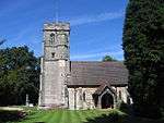 |
| Bridge 160 Yards South West of Goodrest Farmhouse | Leek Wootton, Leek Wootton and Guy's Cliffe, Warwick | Bridge | 1441 | 23 January 1987 | SP2734468912 52°19′03″N 1°36′01″W / 52.317636°N 1.600281°W |
1035180 |
|
| Chapel of St Mary Magdalene | Guy's Cliffe, Leek Wootton and Guy's Cliffe, Warwick | Chapel | Late 14th century | 11 April 1967 | SP2931266810 52°17′55″N 1°34′18″W / 52.298638°N 1.571593°W |
1117390 | 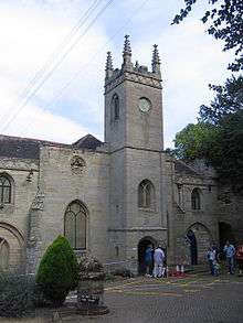 |
| Church of Holy Trinity | Norton Lindsey, Warwick | Parish Church | Early 13th century | 11 April 1967 | SP2292463080 52°15′55″N 1°39′56″W / 52.265407°N 1.665517°W |
1186751 | .jpg) |
| Church of Saint Gregory | Offchurch, Warwick | Church | C11/C12 | 11 April 1967 | SP3581865656 52°17′16″N 1°28′35″W / 52.28788°N 1.476316°W |
1035084 |  |
| Offchurch Bury | Offchurch Bury, Offchurch, Warwick | House | Earlier than late 18th century | 11 April 1967 | SP3451066056 52°17′30″N 1°29′44″W / 52.291559°N 1.49545°W |
1035085 | 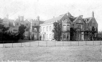 |
| Pinley Abbey and attached Remains of Priory Church | Great Pinley, Rowington, Warwick | House | 19th century | 11 April 1967 | SP2136165760 52°17′22″N 1°41′18″W / 52.289564°N 1.68825°W |
1184435 |
|
| Remains of Priory Church approximately 10 Metres East of Pinley Abbey | Great Pinley, Rowington, Warwick | Workshop | 1990 | 11 April 1967 | SP2138365760 52°17′22″N 1°41′17″W / 52.289563°N 1.687927°W |
1035091 |
|
| The Cottage, approximately 4 Metres North of Pinley Abbey | Great Pinley, Rowington, Warwick | House | 19th century | 11 June 1967 | SP2135865774 52°17′23″N 1°41′18″W / 52.28969°N 1.688293°W |
1184454 |
|
| Yarningale Aqueduct (that Part in Rowington Parish) South Stratford Canal | South Stratford Canal, Rowington, Warwick | Aqueduct | 1834 | 16 February 1990 | SP1839566384 52°17′43″N 1°43′54″W / 52.29528°N 1.7317°W |
1184618 | .jpg) |
| Binswood Hall, North Leamington School | Royal Leamington Spa, Warwick | School | 1847-8 | 25 March 1970 | SP3164466587 52°17′47″N 1°32′15″W / 52.296505°N 1.537419°W |
1381190 | 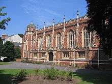 |
| Church of All Saints | Royal Leamington Spa, Warwick | Church | 1825 | 19 November 1953 | SP3200165428 52°17′10″N 1°31′56″W / 52.286065°N 1.532294°W |
1381145 | 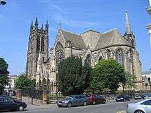 |
| Church of St John the Baptist | Royal Leamington Spa, Warwick | Church | 1877-8 | 25 March 1970 | SP3212264521 52°16′40″N 1°31′50″W / 52.277904°N 1.530606°W |
1381539 |  |
| Church of St Mark | New Milverton, Royal Leamington Spa, Warwick | Church | 1879 | 19 November 1953 | SP3107266310 52°17′39″N 1°32′45″W / 52.294047°N 1.545831°W |
1381515 | 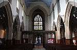 |
| Leamington Real Tennis Club | Royal Leamington Spa, Warwick | Tennis Club | 1846 | 25 March 1970 | SP3169365829 52°17′23″N 1°32′12″W / 52.289687°N 1.536772°W |
1381165 |  |
| Number 1, Lansdowne Circus and attached Railings and Wall | Royal Leamington Spa, Warwick | Villa | c1834-1838 | 19 November 1953 | SP3227566120 52°17′32″N 1°31′42″W / 52.29227°N 1.528211°W |
1381343 |  |
| Numbers 2 and 3, Lansdowne Circus and attached Walls | Royal Leamington Spa, Warwick | Villa | c1834-1838 | 19 November 1953 | SP3227066138 52°17′33″N 1°31′42″W / 52.292432°N 1.528283°W |
1381345 |
|
| Numbers 4 and 5, Lansdowne Circus and attached Walls | Royal Leamington Spa, Warwick | Villa | c1834-1838 | 19 November 1953 | SP3227266155 52°17′33″N 1°31′42″W / 52.292584°N 1.528252°W |
1381346 |
|
| Numbers 6 and 7, Lansdowne Circus and attached Walls | Royal Leamington Spa, Warwick | Villa | c1834-1838 | 19 November 1953 | SP3228066173 52°17′34″N 1°31′41″W / 52.292746°N 1.528133°W |
1381347 |
|
| Numbers 8 and 9, Lansdowne Circus and attached Walls | Royal Leamington Spa, Warwick | Villa | c1834-1838 | 19 November 1953 | SP3229666184 52°17′34″N 1°31′40″W / 52.292844°N 1.527897°W |
1381348 |
|
| Numbers 10 and 11, Lansdowne Circus and attached Walls | Royal Leamington Spa, Warwick | Villa | c1834-1838 | 19 November 1953 | SP3231766180 52°17′34″N 1°31′39″W / 52.292807°N 1.52759°W |
1381349 |  |
| Numbers 12 and 13, Lansdowne Circus and attached Walls | Royal Leamington Spa, Warwick | Villa | c1834-1836 | 19 November 1953 | SP3233266169 52°17′34″N 1°31′39″W / 52.292707°N 1.527371°W |
1381350 |  |
| Numbers 14 and 15, Lansdowne Circus and Attached Walls | Royal Leamington Spa, Warwick | Villa | c1834-1838 | 19 November 1953 | SP3233966151 52°17′33″N 1°31′38″W / 52.292545°N 1.52727°W |
1381351 |
|
| Numbers 16 and 17, Lansdowne Circus and attached Walls | Royal Leamington Spa, Warwick | Villa | c1834-1838 | 19 November 1953 | SP3233866132 52°17′33″N 1°31′38″W / 52.292374°N 1.527287°W |
1381352 |  |
| Numbers 12-42, Parade and attached Railings to Numbers 16 and 18 and 20a | Royal Leamington Spa, Warwick | Flats | 1953 | 19 November 1953 | SP3173866134 52°17′33″N 1°32′10″W / 52.292427°N 1.536083°W |
1381407 |
|
| Numbers 1-6, Clarence Mansions and attached Railings | Royal Leamington Spa, Warwick | Flats | 1999 | 19 November 1953 | SP3150866039 52°17′30″N 1°32′22″W / 52.291586°N 1.539464°W |
1381225 |  |
| Numbers 19-57, Lansdowne Crescent and attached Railings | Royal Leamington Spa, Warwick | Flats | 1999 | 19 November 1953 | SP3219966134 52°17′33″N 1°31′46″W / 52.2924°N 1.529324°W |
1381354 | 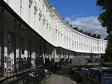 |
| Regent Hotel | Royal Leamington Spa, Warwick | Hotel | 1818-1819 | 19 November 1953 | SP3180765840 52°17′23″N 1°32′06″W / 52.28978°N 1.535099°W |
1381422 | 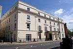 |
| 83 and 83a Holly Walk (upper) | Royal Leamington Spa, Warwick | Villa | c. 1838 | 15 February 1973 | SP3230366075 52°17′31″N 1°31′40″W / 52.291863°N 1.527805°W |
1381314 | 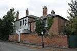 |
| Church of All Saints | Sherbourne, Warwick | Parish Church | 1862-4 | 11 April 1967 | SP2622361184 52°14′54″N 1°37′02″W / 52.248216°N 1.617324°W |
1035139 |  |
| Sherbourne Park | Sherbourne, Warwick | House | c. 1700 | 11 April 1967 | SP2629761294 52°14′57″N 1°36′58″W / 52.249201°N 1.616232°W |
1035141 |
|
| Conservatory 7 Yards to South of Stoneleigh Abbey | Stoneleigh, Warwick | Conservatory | 1770 | 11 April 1967 | SP3188271202 52°20′17″N 1°32′01″W / 52.337979°N 1.533493°W |
1087012 |
|
| Iron Gate and Screen 11 Yards to South of South Wing of Stoneleigh Abbey | Stoneleigh, Warwick | Gate | 1770 | 23 January 1987 | SP3186271222 52°20′17″N 1°32′02″W / 52.33816°N 1.533785°W |
1086942 |
|
| Moat Farmhouse | Stoneleigh, Warwick | Farmhouse | Late 15th century or early 16th century | 11 November 1952 | SP2614275147 52°22′25″N 1°37′03″W / 52.373747°N 1.617431°W |
1075940 |
|
| New Bridge | Stoneleigh, Warwick | Bridge | 1814 | 10 September 1973 | SP3144571521 52°20′27″N 1°32′24″W / 52.340872°N 1.539877°W |
1035264 |  |
| Stables and Riding School 100 Yards North East of Stoneleigh Abbey | Stoneleigh, Warwick | House | 1814 | 30 November 1982 | SP3200271312 52°20′20″N 1°31′54″W / 52.338961°N 1.531722°W |
1364976 | .jpg) |
| Stare Bridge | River Avon, Stoneleigh, Warwick | Bridge | Late 15th century | 11 April 1967 | SP3296071457 52°20′25″N 1°31′04″W / 52.340208°N 1.517647°W |
1106390 | 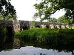 |
| Church of Saint John the Baptist | Wappenbury, Warwick | Parish Church | circa 13th century | 11 April 1967 | SP3780469282 52°19′13″N 1°26′48″W / 52.320344°N 1.446796°W |
1106276 | .jpg) |
| Allens House | Warwick | Timber Framed House | Late 16th century | 10 January 1953 | SP2854664753 52°16′49″N 1°34′59″W / 52.280186°N 1.582999°W |
1035426 | 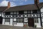 |
| Castle Bridge | Warwick | Bridge | 1790-1793 | 10 January 1953 | SP2878064690 52°16′47″N 1°34′46″W / 52.279607°N 1.579574°W |
1184083 | .jpg) |
| Conservatory | Warwick Castle Park, Warwick | Conservatory | Late 18th century | 19 March 1973 | SP2817664694 52°16′47″N 1°35′18″W / 52.279675°N 1.588427°W |
1184061 |  |
| East Gate, St Peters Chapel | Warwick | Gatehouse | 15th century | 10 January 1953 | SP2840964986 52°16′56″N 1°35′06″W / 52.282288°N 1.584987°W |
1035501 | 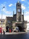 |
| Elizabethan House | Warwick | House | 18th century | 10 January 1953 | SP2805464711 52°16′47″N 1°35′25″W / 52.279834°N 1.590214°W |
1035432 | 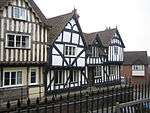 |
| Entrance Gateway to St John's House and Flanking Boundary Walls | Warwick | Gate | Late 17th century | 19 March 1973 | SP2870165122 52°17′01″N 1°34′51″W / 52.283495°N 1.580696°W |
1035400 |  |
| Landor House | Warwick | House | 1692-1693 | 10 January 1953 | SP2843165014 52°16′57″N 1°35′05″W / 52.282538°N 1.584663°W |
1185233 |  |
| Longbridge Manor | Longbridge, Warwick | House | Late 16th century or Early 17th century | 10 January 1953 | SP2684962570 52°15′38″N 1°36′29″W / 52.260646°N 1.608046°W |
1364837 |
|
| Museum | Warwick | Market Hall | Late 17th century | 10 January 1953 | SP2802264924 52°16′54″N 1°35′26″W / 52.28175°N 1.590665°W |
1035417 | 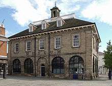 |
| Norman Arch in Garden of Lord Leicesters Hospital | Warwick | Chapel | Norman | 10 January 1953 | SP2800664762 52°16′49″N 1°35′27″W / 52.280294°N 1.590913°W |
1184544 |
|
| Okens House | Warwick | House | 1864 | 10 January 1953 | SP2828064804 52°16′50″N 1°35′13″W / 52.280658°N 1.586894°W |
1364795 | 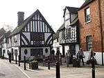 |
| Portion of Boundary Wall to Warwick Castle abutting Mill Street | Warwick | Castle | Late 18th century | 10 January 1953 | SP2849464714 52°16′47″N 1°35′02″W / 52.279838°N 1.583764°W |
1364806 |  |
| Quaker Meeting House | Warwick | Friends Meeting House | 1690S | 10 January 1953 | SP2808064738 52°16′48″N 1°35′23″W / 52.280075°N 1.589831°W |
1035431 | 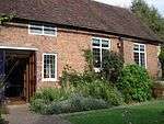 |
| Remains of Old Castle Bridge | Warwick | Bridge | Late Medieval | 10 January 1953 | SP2853264624 52°16′44″N 1°35′00″W / 52.279027°N 1.583215°W |
1035499 |  |
| St Michael's Place | Saltisford, Warwick | House | 1973 | 10 January 1953 | SP2770265422 52°17′10″N 1°35′43″W / 52.286243°N 1.595315°W |
1364850 | _-_geograph.org.uk_-_506328.jpg) |
| 108, 108a Saltisford | Saltisford, Warwick | Chapel | 1973 | 10 January 1953 | SP2769665398 52°17′10″N 1°35′43″W / 52.286028°N 1.595405°W |
1035366 | 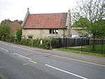 |
| Stables Warwick Castle | Warwick | Stable | 1768-1771 | 10 January 1953 | SP2836364809 52°16′51″N 1°35′08″W / 52.280699°N 1.585677°W |
1035508 |
|
| The Athenaeum | Warwick | Club | 18th century | 10 January 1953 | SP2822464915 52°16′54″N 1°35′16″W / 52.281659°N 1.587705°W |
1364798 |  |
| The Gables | Warwick | House | Later alteration | 10 January 1953 | SP2853664736 52°16′48″N 1°34′59″W / 52.280034°N 1.583147°W |
1184801 |  |
| The Marble House | Warwick | House | Early 17th century | 10 January 1953 | SP2787764967 52°16′56″N 1°35′34″W / 52.282144°N 1.592787°W |
1185275 | 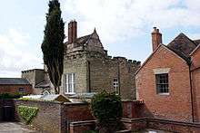 |
| The Priory | Warwick | House | 16th century | 10 January 1953 | SP2826365280 52°17′06″N 1°35′14″W / 52.284938°N 1.587103°W |
1035503 |
|
| Warwick Castle Mill | Warwick | Castle | 1767-1768 | 10 January 1953 | SP2846364660 52°16′46″N 1°35′03″W / 52.279354°N 1.584223°W |
1035507 |  |
| Warwickshire County Council Staff Club, Northgate and Northgate House | Northgate, Warwick | House | Late 17th century | 10 January 1953 | SP2812265141 52°17′01″N 1°35′21″W / 52.283696°N 1.589181°W |
1364826 |  |
| Woodloes Farmhouse | Warwick | Farmhouse | 1562 | 10 January 1953 | SP2781567003 52°18′02″N 1°35′37″W / 52.300451°N 1.593529°W |
1035360 |
|
| 43 Mill Street | Warwick | House | 18th century | 10 January 1953 | SP2852764723 52°16′48″N 1°35′00″W / 52.279917°N 1.58328°W |
1035427 |  |
| 10 Market Place | Warwick | House | 1714 | 10 January 1953 | SP2802265015 52°16′57″N 1°35′26″W / 52.282568°N 1.590658°W |
1184698 | .jpg) |
| 18 and 20 Northgate Street | Warwick | House | Late 17th century (From 1694) | 10 January 1953 | SP2814665077 52°16′59″N 1°35′20″W / 52.283119°N 1.588835°W |
1364829 |  |
| 1, Jury Street | Warwick | House/Shops | Late 17th century | 10 January 1953 | SP2824364883 52°16′53″N 1°35′15″W / 52.28137°N 1.587429°W |
1364813 | 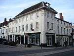 |
| 33, 35 Jury Street (Porridge Pot) | Warwick | House | 17th century | 10 January 1953 | SP2835464968 52°16′56″N 1°35′09″W / 52.282129°N 1.585795°W |
1035448 |
|
| 1 and 1a Brook Street | Warwick | Open Hall House | 15th century | 10 January 1953 | SP2806164759 52°16′49″N 1°35′24″W / 52.280265°N 1.590107°W |
1300104 | .jpg) |
| 90, 92 West Street | Warwick | House/Inn | Later alteration | 10 January 1953 | SP2782564407 52°16′38″N 1°35′37″W / 52.277112°N 1.593595°W |
1035350 | .jpg) |
| 1, High Street | Warwick | House/Restaurant | Late 17th century | 10 January 1953 | SP2823764850 52°16′52″N 1°35′15″W / 52.281074°N 1.58752°W |
1035464 |  |
| 2, 4 High Street | Warwick | House/Shop | Late 17th century | 10 January 1953 | SP2822264869 52°16′52″N 1°35′16″W / 52.281245°N 1.587738°W |
1364844 | 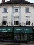 |
| 23, 25 Market Place | Warwick | Jettied House | c. 1634 | 10 January 1953 | SP2807864906 52°16′54″N 1°35′23″W / 52.281585°N 1.589846°W |
1364840 |
|
| Old Manor House | Wasperton, Warwick | House | 18th century | 11 April 1967 | SP2641058805 52°13′37″N 1°36′53″W / 52.226819°N 1.61477°W |
1325532 | |
See also
Notes
- ↑ The date given is the date used by Historic England as significant for the initial building or that of an important part in the structure's description.
- ↑ Sometimes known as OSGB36, the grid reference is based on the British national grid reference system used by the Ordnance Survey.
- ↑ The "List Entry Number" is a unique number assigned to each listed building and scheduled monument by Historic England.
External links
![]() Media related to Grade II* listed buildings in Warwickshire at Wikimedia Commons
Media related to Grade II* listed buildings in Warwickshire at Wikimedia Commons
This article is issued from Wikipedia - version of the 10/6/2016. The text is available under the Creative Commons Attribution/Share Alike but additional terms may apply for the media files.