Gramercy, Louisiana
| Town of Gramercy | |
| Town | |
| Country | United States |
|---|---|
| State | Louisiana |
| Parish | St. James |
| Elevation | 16 ft (4.9 m) |
| Coordinates | 30°03′14″N 90°41′21″W / 30.05389°N 90.68917°WCoordinates: 30°03′14″N 90°41′21″W / 30.05389°N 90.68917°W |
| Area | 2.1 sq mi (5.4 km2) |
| - land | 2.1 sq mi (5 km2) |
| - water | 0.0 sq mi (0 km2), 0% |
| Population | 3,613 (2010) |
| Density | 1,477.6/sq mi (570.5/km2) |
| Timezone | CST (UTC-6) |
| - summer (DST) | CDT (UTC-5) |
| Area code | 225 |
|
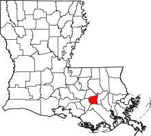
Location of Gramercy in Louisiana | |
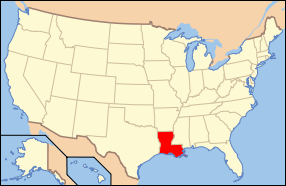
 Location of Louisiana in the United States | |
Gramercy is a town in St. James Parish, Louisiana, United States. The population was 3,613 at the 2010 census.
History
Gramercy was originally an Indian and French settlement and trading post. In 1739, much of the area which is now known as Gramercy was sold to Joseph Delille Dupart, Commissioner of Indian Nations under Jean-Baptiste Le Moyne de Bienville. The town was incorporated in November 1947.[1] A historic sugar mill was established in Gramercy in 1895, which became the Colonial Sugar Refinery in 1902. The National Park Service has designated the site as the Colonial Sugar National Historic District.[2]
Geography
Gramercy is located at 30°3′14″N 90°41′21″W / 30.05389°N 90.68917°W (30.053907, -90.689154).[3] Gramercy is bordered on the west by the town of Lutcher and on the south by the Mississippi River.
According to the United States Census Bureau, the town has a total area of 2.1 square miles (5.4 km2), of which, 2.1 square miles (5.4 km2) of it is land and 0.04 square miles (0.10 km2) of it (1.42%) is water.
Industry
Gramercy is the home of Zapp's Potato Chips[4] and Louisiana Sugar Refining, LLC (LSR).
LSR operates a state-of-the-art sugar refinery with a capacity of 3,100 tons per day. The refinery employs about 150 people.[5] LSR is located in the Colonial Sugars National Historic District.[2]
Demographics
| Historical population | |||
|---|---|---|---|
| Census | Pop. | %± | |
| 1950 | 1,184 | — | |
| 1960 | 2,094 | 76.9% | |
| 1970 | 2,567 | 22.6% | |
| 1980 | 3,211 | 25.1% | |
| 1990 | 2,412 | −24.9% | |
| 2000 | 3,066 | 27.1% | |
| 2010 | 3,613 | 17.8% | |
| Est. 2015 | 3,457 | [6] | −4.3% |
As of the census[8] of 2000, there were 3,066 people, 1,090 households, and 833 families residing in the town. The population density was 1,477.6 people per square mile (571.9/km²). There were 1,163 housing units at an average density of 560.5 per square mile (216.9/km²). The racial makeup of the town was 63.60% White, 34.83% African American, 0.46% Native American, 0.10% Asian, and 1.01% from two or more races. Hispanic or Latino of any race were 0.72% of the population.
There were 1,090 households out of which 35.0% had children under the age of 18 living with them, 53.4% were married couples living together, 18.1% had a female householder with no husband present, and 23.5% were non-families. 20.8% of all households were made up of individuals and 7.9% had someone living alone who was 65 years of age or older. The average household size was 2.81 and the average family size was 3.27.
In the town the population was spread out with 28.6% under the age of 18, 7.5% from 18 to 24, 30.0% from 25 to 44, 21.1% from 45 to 64, and 12.7% who were 65 years of age or older. The median age was 35 years. For every 100 females there were 95.3 males. For every 100 females age 18 and over, there were 89.4 males.
The median income for a household in the town was $33,824, and the median income for a family was $39,350. Males had a median income of $39,013 versus $22,750 for females. The per capita income for the town was $14,040. About 17.4% of families and 21.3% of the population were below the poverty line, including 29.2% of those under age 18 and 10.0% of those age 65 or over.
Notable residents
- Robert Faucheux, former state representative for St. James and St. John the Baptist parishes; former attorney in Gramercy
- Alfred C. Williams, state representative for East Baton Rouge Parish since 2015; former Gramercy resident[9]
- Nicondra Norwood, Meteorologist WVUE FOX 8 New Orleans.
See also
| Wikimedia Commons has media related to Gramercy, Louisiana. |
- Zapp's—a brand of highly seasoned, kettle-style potato chips manufactured in Gramercy.
- St. James Parish, Louisiana
References
- ↑ Louisiana Department of Culture, Recreation and Tourism. "Gramercy Historical Marker". Retrieved August 9, 2009.
- 1 2 Colonial Sugar Historic District, National Park Service.
- ↑ "US Gazetteer files: 2010, 2000, and 1990". United States Census Bureau. 2011-02-12. Retrieved 2011-04-23.
- ↑ Zapp's Potato Chips
- ↑ Louisiana Sugar Refining, LLC
- ↑ "Annual Estimates of the Resident Population for Incorporated Places: April 1, 2010 to July 1, 2015". Retrieved July 2, 2016.
- ↑ "Census of Population and Housing". Census.gov. Retrieved June 4, 2015.
- ↑ "American FactFinder". United States Census Bureau. Retrieved 2008-01-31.
- ↑ "Alfred C. Williams". intelius.com. Retrieved April 24, 2015.
