Weil am Rhein
| Weil am Rhein, Germany | ||
|---|---|---|
|
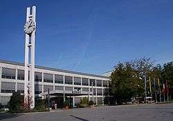
Townhall and market place of Weil am Rhein | ||
| ||
 Weil am Rhein, Germany | ||
| Coordinates: 47°35′41″N 7°36′39″E / 47.59472°N 7.61083°ECoordinates: 47°35′41″N 7°36′39″E / 47.59472°N 7.61083°E | ||
| Country | Germany | |
| State | Baden-Württemberg | |
| Admin. region | Freiburg | |
| District | Lörrach | |
| Government | ||
| • Mayor | Wolfgang Dietz (CDU) | |
| Area | ||
| • Total | 19.47 km2 (7.52 sq mi) | |
| Population (2015-12-31)[1] | ||
| • Total | 30,030 | |
| • Density | 1,500/km2 (4,000/sq mi) | |
| Time zone | CET/CEST (UTC+1/+2) | |
| Postal codes | 79546–79576 | |
| Dialling codes | 07621 | |
| Vehicle registration | LÖ | |
| Website | www.weil-am-rhein.de | |

Weil am Rhein is a German town and commune. It is on the east bank of the River Rhine, and close to the point at which the Swiss, French and German borders meet. It is the most southwesterly town in Germany.
Geography
Weil am Rhein is located at 47°35′42″N 7°36′39.6″E / 47.59500°N 7.611000°E in the district of Lörrach in the Federal State of Baden-Württemberg. The city limits border France to the west and Switzerland to the south including the triple border of the three countries. Locally, Weil is situated in the region referred to as Markgräflerland.
The city's location on the Rhine and proximity to the Black Forest give it a continental climate, particularly suited to viticulture.
History
The town is first documented in the year 786 as Willa, a name which is thought to be of Roman origin. The duc de Villars crossed the Rhine here in October 1702 to fight the Battle of Friedlingen during the War of the Spanish Succession. Weil was severely damaged as a result of the conflict.
Agriculture dominated local industry until the 19th century, when the city began to grow, aided by its favourable transport connections. A railway marshalling yard linking Weil am Rhein to Basel was built in 1913. Swiss textile factories were established in the Friedlingen quarter. 1934 saw the construction of a harbour on the Rhine.
After the Second World War the population again grew rapidly due to the influx of refugees and stateless persons. Between 1971 and 1975 the communities of Ötlingen, Haltingen and Märkt were incorporated and Weil am Rhein became a substantial town.
Mergers
The former municipalities were merged into Weil am Rhein:
- Coat of arms of the former municipalities
-

Haltingen
-

Märkt
-

Ötlingen
International relations
Weil am Rhein is twinned with:
-
 Bognor Regis (United Kingdom)
 -
 Huningue (France)
 -
 Trebbin (eastern Germany)
Tourism and leisure

- The premises of the furniture maker Vitra, featuring buildings by architects such as Frank Gehry, Zaha Hadid and Tadao Ando, are an attraction for architecture fans. The premises also include the Vitra Design Museum.
- The Laguna water park
- Landesgartenschau Baden-Württemberg 1999, "Grün 99"[5]
References
- ↑ "Gemeinden in Deutschland nach Fläche, Bevölkerung und Postleitzahl am 30.09.2016". Statistisches Bundesamt (in German). 2016.
- ↑ Portrait of Ötlingen (in German). Retrieved 30 June 2014.
- ↑ Portrait of Haltingen (in German). Retrieved 30 June 2014.
- ↑ Portrait of Märkt (in German). Retrieved 30 June 2014.
- ↑ 1999 Landesgartenschau Weil am Rhein (in German). Retrieved 30 June 2014.
External links
- Official site (German)
- Vitra Design Museum (German)(English)
- Laguna water park (German)
- Weil am Rhein: pictures (German)