Huningue
| Huningue | ||
|---|---|---|
|
Place Abbatucci | ||
| ||
 Huningue | ||
|
Location within Grand Est region  Huningue | ||
| Coordinates: 47°35′31″N 7°35′04″E / 47.5919°N 7.5844°ECoordinates: 47°35′31″N 7°35′04″E / 47.5919°N 7.5844°E | ||
| Country | France | |
| Region | Grand Est | |
| Department | Haut-Rhin | |
| Arrondissement | Mulhouse | |
| Canton | Huningue | |
| Intercommunality | Trois Frontières | |
| Government | ||
| • Mayor (2008–2014) | Jean-Marc Deichtmann | |
| Area1 | 2.86 km2 (1.10 sq mi) | |
| Population (2008)2 | 6,503 | |
| • Density | 2,300/km2 (5,900/sq mi) | |
| Time zone | CET (UTC+1) | |
| • Summer (DST) | CEST (UTC+2) | |
| INSEE/Postal code | 68149 / 68330 | |
| Dialling codes | 0389 | |
| Elevation | 242–259 m (794–850 ft) | |
|
1 French Land Register data, which excludes lakes, ponds, glaciers > 1 km² (0.386 sq mi or 247 acres) and river estuaries. 2 Population without double counting: residents of multiple communes (e.g., students and military personnel) only counted once. | ||
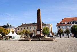

Huningue (French pronunciation: [ynɛ̃ɡ]; German: Hüningen; Alsatian: Hinige) is a commune in the Haut-Rhin department of Alsace in north-eastern France. Huningue is a northern suburb of the Swiss city of Basel.[lower-alpha 1] It also borders Germany (Weil am Rhein, a suburb of Basel located in Germany). In 2008 it had a population of 6503 people. The main square of the town is the Place Abbatucci, named after the Corsican-born French general Jean Charles Abbatucci who unsuccessfully defended it in 1796 against the Austrians and died here. Huningue is noted for its pisciculture and is a major producer of fish eggs.
History

Huningue was first mentioned in a document in 826. Huningue was wrested from the Holy Roman Empire by the duke of Lauenburg in 1634 by the Treaty of Westphalia, and subsequently passed by purchase to Louis XIV. Louis XIV ordered the construction of the Huningue Fortress and was fortified by Vauban (1679–1681) and a bridge was built across the Rhine.[1] Construction of the fortress required the displacement of the population on the island of Aoust and the surrounding area. In 1796 to 1797, Huningue was besieged by the Austrians.[2] During the siege the French Commander, General Abbatucci was killed on 1 December 1796 while commanding a sortie, the fort held out for a further month surrendering on 5 February 1797. The fortress was besieged from 22 December 1813 until 14 April 1814 by Bavarian troops under the command of General Zoller before the French garrison surrendered.[3] Huningue was besieged for the third time in 1815 and General Barbanègre headed a garrison of only 500 men against 25,000 Austrians.[2] On the 28 June shortly after word of Napoleon's abdication became known, and the French Provisional Government had requested a ceasefire, Barbanègre ordered the bombardment of Basel something that contemporaries on the Seventh Coalition side considers to be a war crime.[4] At its surrender to the Habsburg Empire on 26 August 1815, the city was a ruin and the fortifications were demolished under the terms of Article III of the Treaty of Paris (1815) at the request of Basel.[5]
The building of the Huningue channel in 1828 made the area more navigable (the entire channel system was completed in 1834);[6] it provided water to the Rhone-Rhine canal. The Huningue canal is a feeder arm of this Rhone-Rhine Canal; it enters the river opposite the main dock basins.[7] Only about a kilometre of the canal is still navigable, leading to the town of Kembs.[8]
In 1871, the town passed, with Alsace-Lorraine, to the German Empire.[9] Alsace-Lorraine returned to France after the First World War. It was evacuated in 1939, retaken by Germany in 1940 with some 60% of the town destroyed during World War II, and finally returned to France once again in 1945. In 2007, a bridge over the Rhine, linking Huningue with Weil am Rhein, Germany was built.
Geography
Huningue is situated on the left bank of the Rhine, and is an ancient place which grew up around a stronghold placed to guard the passage of the river. It is a northern suburb of Basel.
Economy
Huningue is noted for its pisciculture and is a major producer of fish eggs.[10][11] Several chemical, plastics and pharmaceutical companies have factories in Huningue, mainly Swiss firms such as Novartis, Ciba, Clariant, Hoffmann-La Roche, Weleda etc. The Rhine port is managed by the Chamber of Commerce and the industry of Mulhouse, which lies to the northwest of Huningue.
Notable landmarks
Since March 2007 Huningue is connected with Weil am Rhein via an arch bridge. With 248 meters of length it is the longest of its kind for pedestrians and cyclist. Because the bridge connects the two countries France and Germany and is near Switzerland it is named the Three country bridge or Passerelle des Trois Pays in French.
- Musée historique et militaire : The military and historical museum evokes the military life of the ancient fortress of Vauban. The museum is housed in a former residence of the intendant of the place and commissary.
- L'ancienne église de garnison : the former garrison church was built according to plans of the engineer Jacques Tarade; the church which dominates the Place Abattucci is now disused as a church. The building occasionally is host to concerts of chamber music. It also serves as a polling station during elections. Since 1938, the facades, the bell tower and the roof have been listed in the inventory of historical monuments.
- Parc des Eaux Vives and the Wheelhouse : a park with an artificial torrent, with kayaking, canoeing, and white water rafting.
- Le Triangle - The Triangle is a cultural complex covering 5540 square metres, divided into 21 activity rooms. Created by architect Jean-Marie Martini, it was inaugurated in February 2002. In addition to the many varied shows (dance, theater, music, circus arts, comedy), the Triangle also hosts exhibitions (sculpture, painting, writing) and a forum for the exchange of information and entertainment for the young . In addition, regular tea dances are organized, philosophy workshops and hearings of the Academy of Arts (music, dance, theater), conferences and meetings with artists.
Notable people
- Sébastien Le Prestre de Vauban - architect of Louis XIV, he directed the construction of the fortress of Huningue.
- Jean-Charles Abbatucci - General of the Army of the Rhine. He lost his life due to his injuries during an event during the first siege of the city in 1796.
- Joseph Barbanègre - French General, entrenched in Huningue during the third siege of the city in 1815.
- Armand Blanchard - French director, born in Huningue. He was mayor of Mulhouse from 1825 to 1830.
- Michel Ordener, Major General, born in Huningue on April 3, 1787. He was the son of General Michel Ordener.
- Johnny Stark: producer and imprésario (1922 in Huningue - 1989 in Paris)
Gallery
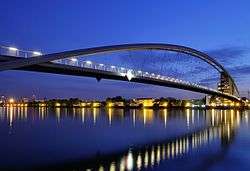 Three country bridge
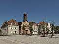 Place Abbatucci with church (ancienne église Saint-Louis)
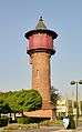 Château d'eau
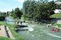 Le parc des Eaux Vives
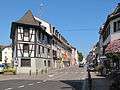 Huningue, view to a street
Notes
- ↑ Under the treaty of Paris (1815) the spelling of the town in the official English translation was Huninguen (as it was in many other contemporary English language sources).
- ↑ Malte-Brun, Conrad (1831). Universal Geography, Or, a Description of All the Parts of the World, on a New Plan: Spain, Portugal, France, Norway, Sweden, Denmark, Belgium, and Holland. A. Black. p. 395. Retrieved 26 October 2011.
- 1 2 Jaques 2007, p. 462.
- ↑ Bourdet 1968, p. 217.
- ↑ MacQueen 1816, p. 420.
- ↑ Jerrold 1874, p. 343.
- ↑ The Encyclopaedia Britannica, or Dictionary of Arts, Sciences, and General Literature. Black. 1842. p. 6. Retrieved 26 October 2011.
- ↑ Harbour authority (1 January 1955). The Dock and harbour authority. Foxlow Publications, ltd. pp. 138, 142. Retrieved 26 October 2011.
- ↑ McKnight, Hugh (September 2005). Cruising French Waterways. Sheridan House, Inc. p. 109. ISBN 978-1-57409-210-3. Retrieved 26 October 2011.
- ↑ Pounds, Norman John Greville (1963). Political geography. McGraw-Hill. p. 249. Retrieved 26 October 2011.
- ↑ Chambers's encyclopædia: a dictionary of universal knowledge. W. & R. Chambers. 1868. p. 559. Retrieved 26 October 2011.
- ↑ Dallas, Eneas Sweetland (1862). Once a week. Bradbury & Evans. p. 206. Retrieved 26 October 2011.
References
- Bourdet, Jacques, ed. (1968). The Ancient Art of Warfare: The modern ages; 1700 to our times, from Peter the Great to Eisenhower, soldiers of cannons, tanks, and planes. The Ancient Art of Warfare, The Ancient Art of Warfare. 2. R. Laffont.
- Jaques, Tony (2007). Dictionary of Battles and Sieges: F-O. Greenwood Publishing Group. p. 462. ISBN 978-0-313-33538-9.
- Jerrold, Blanchard (1874). The life of Napoleon III: derived from state records, from unpublished family correspondence, and from personal testimony; with family portraits in the possession of the imperial family, and facsimiles of letters of Napoleon I., Napoleon III., Queen Hortense, &c. Longmans, Green. p. 343.
- MacQueen, James (1816). A narrative of the political and military events of 1815: intended to complete the narrative of the campaigns of 1812, 1813, and 1814. Printed for the author, by E. Khull & Co. and sold by John Smith & Son. p. 420.
Attribution
 This article incorporates text from a publication now in the public domain: Chisholm, Hugh, ed. (1911). "Hüningen". Encyclopædia Britannica. 13 (11th ed.). Cambridge University Press. p. 932. Endontes
- Tschamber (1894). Geschichte der Stadt und ehemaligen Festung Hüningen. St Ludwig.
- Latruffe (1863). Huningue et Bâle devant les traités de 1815. Paris.
External links
| Wikimedia Commons has media related to Huningue. |