Harbor Beach, Michigan
| Harbor Beach, Michigan | |
|---|---|
| City | |
 Location of Harbor Beach, Michigan | |
| Coordinates: 43°50′41″N 82°39′05″W / 43.84472°N 82.65139°W | |
| Country | United States |
| State | Michigan |
| County | Huron |
| Government | |
| • Mayor | Gary Booms |
| Area[1] | |
| • Total | 2.09 sq mi (5.41 km2) |
| • Land | 1.75 sq mi (4.53 km2) |
| • Water | 0.34 sq mi (0.88 km2) |
| Elevation | 600 ft (183 m) |
| Population (2010)[2] | |
| • Total | 1,703 |
| • Estimate (2012[3]) | 1,669 |
| • Density | 973.1/sq mi (375.7/km2) |
| Time zone | Eastern (EST) (UTC-5) |
| • Summer (DST) | EDT (UTC-4) |
| ZIP code | 48441 |
| Area code(s) | 989 |
| FIPS code | 26-36460[4] |
| GNIS feature ID | 0627752[5] |
Harbor Beach is a city in Huron County in the U.S. state of Michigan. The population was 1,703 at the 2010 census.
Geography
- According to the United States Census Bureau, the city has a total area of 2.09 square miles (5.41 km2), of which 1.75 square miles (4.53 km2) is land and 0.34 square miles (0.88 km2) is water.[1]
- The world's largest man-made fresh water harbor offers a harbor of refuge to ships traveling between Port Huron and Pointe Aux Barques.[6]
- It is considered to be part of the Thumb of Michigan, which in turn is a subregion of the Flint/Tri-Cities region.
- The two main state highways are M-25 and M-142.
Demographics
| Historical population | |||
|---|---|---|---|
| Census | Pop. | %± | |
| 1880 | 534 | — | |
| 1890 | 1,046 | 95.9% | |
| 1900 | 1,149 | 9.8% | |
| 1910 | 1,556 | 35.4% | |
| 1920 | 1,927 | 23.8% | |
| 1930 | 1,892 | −1.8% | |
| 1940 | 2,186 | 15.5% | |
| 1950 | 2,349 | 7.5% | |
| 1960 | 2,282 | −2.9% | |
| 1970 | 2,134 | −6.5% | |
| 1980 | 2,000 | −6.3% | |
| 1990 | 2,089 | 4.5% | |
| 2000 | 1,837 | −12.1% | |
| 2010 | 1,703 | −7.3% | |
| Est. 2015 | 1,634 | [7] | −4.1% |
2010 census
As of the census[2] of 2010, there were 1,703 people, 774 households, and 454 families residing in the city. The population density was 973.1 inhabitants per square mile (375.7/km2). There were 975 housing units at an average density of 557.1 per square mile (215.1/km2). The racial makeup of the city was 96.4% White, 0.2% African American, 0.4% Native American, 1.1% Asian, 0.2% from other races, and 1.8% from two or more races. Hispanic or Latino of any race were 0.6% of the population.
There were 774 households of which 24.0% had children under the age of 18 living with them, 43.8% were married couples living together, 11.2% had a female householder with no husband present, 3.6% had a male householder with no wife present, and 41.3% were non-families. 37.9% of all households were made up of individuals and 22.2% had someone living alone who was 65 years of age or older. The average household size was 2.14 and the average family size was 2.80.
The median age in the city was 47.7 years. 20.4% of residents were under the age of 18; 7.4% were between the ages of 18 and 24; 19.5% were from 25 to 44; 29.9% were from 45 to 64; and 22.7% were 65 years of age or older. The gender makeup of the city was 47.5% male and 52.5% female.
2000 census
As of the census[4] of 2000, there were 1,837 people, 774 households, and 503 families residing in the city. The population density was 1,036.3 per square mile (400.7/km²). There were 928 housing units at an average density of 523.5 per square mile (202.4/km²). The racial makeup of the city was 96.35% White, 0.11% African American, 0.49% Native American, 1.36% Asian, 0.38% from other races, and 1.31% from two or more races. Hispanic or Latino of any race were 0.93% of the population.
There were 774 households out of which 29.5% had children under the age of 18 living with them, 51.4% were married couples living together, 10.2% had a female householder with no husband present, and 34.9% were non-families. 32.3% of all households were made up of individuals and 16.8% had someone living alone who was 65 years of age or older. The average household size was 2.31 and the average family size was 2.92.
In the city the population was spread out with 24.5% under the age of 18, 6.8% from 18 to 24, 23.8% from 25 to 44, 22.9% from 45 to 64, and 22.1% who were 65 years of age or older. The median age was 42 years. For every 100 females there were 91.4 males. For every 100 females age 18 and over, there were 86.9 males.
The median income for a household in the city was $29,469, and the median income for a family was $35,263. Males had a median income of $29,938 versus $18,864 for females. The per capita income for the city was $14,917. About 11.2% of families and 15.1% of the population were below the poverty line, including 24.8% of those under age 18 and 12.2% of those age 65 or over.
History
The earliest settlers to this area arrived in 1837 and established a sawmill for processing lumber. The settlement eventually was named Barnettsville in 1855, as the settlement continued to grow, the town was renamed Sand Beach. In 1899, the village of Sand Beach changed its name to Harbor Beach, because of the impression that the area has nothing but sand. In 1910, it was officially incorporated into a city.
Located on western shore of Lake Huron in the Thumb of Michigan, Harbor Beach is known as having the world's largest man-made fresh water harbor and boasts a fishing pier that is handicap accessible. The municipal marina provides transient services and shuttle services into the downtown area which has retained its old town charm.
The Murphy Museum and the Grice House Museum feature history of the area. Wagener County Park, just south on M-25, and North Park Campgrounds, across from the marina, offer complete camping facilities and groomed hiking and cross country ski trails.
The association known as HBRA was founded in 1896 as a summertime vacation spot in Harbor Beach. The resort is located roughly three hours north of Detroit, MI and is currently still operated, and frequented, by the 5th and 6th generation descendents of the original founding families.
Harbor Beach won the 2012 Division 8 State Football Championship.
Climate
| Climate data for Harbor Beach, Michigan (1981–2010 normals, extremes 1899–present) | |||||||||||||
|---|---|---|---|---|---|---|---|---|---|---|---|---|---|
| Month | Jan | Feb | Mar | Apr | May | Jun | Jul | Aug | Sep | Oct | Nov | Dec | Year |
| Record high °F (°C) | 62 (17) |
68 (20) |
84 (29) |
89 (32) |
92 (33) |
100 (38) |
105 (41) |
102 (39) |
98 (37) |
88 (31) |
80 (27) |
65 (18) |
105 (41) |
| Average high °F (°C) | 27.9 (−2.3) |
29.8 (−1.2) |
37.6 (3.1) |
49.2 (9.6) |
60.0 (15.6) |
69.9 (21.1) |
75.7 (24.3) |
74.8 (23.8) |
68.3 (20.2) |
56.2 (13.4) |
43.9 (6.6) |
32.4 (0.2) |
52.1 (11.2) |
| Daily mean °F (°C) | 21.7 (−5.7) |
22.9 (−5.1) |
30.7 (−0.7) |
41.7 (5.4) |
52.0 (11.1) |
61.8 (16.6) |
67.5 (19.7) |
66.7 (19.3) |
59.7 (15.4) |
48.5 (9.2) |
37.8 (3.2) |
27.1 (−2.7) |
44.8 (7.1) |
| Average low °F (°C) | 15.5 (−9.2) |
15.9 (−8.9) |
23.9 (−4.5) |
34.1 (1.2) |
43.9 (6.6) |
53.7 (12.1) |
59.4 (15.2) |
58.5 (14.7) |
51.2 (10.7) |
40.9 (4.9) |
31.6 (−0.2) |
21.7 (−5.7) |
37.5 (3.1) |
| Record low °F (°C) | −19 (−28) |
−22 (−30) |
−12 (−24) |
3 (−16) |
24 (−4) |
32 (0) |
38 (3) |
35 (2) |
21 (−6) |
17 (−8) |
4 (−16) |
−14 (−26) |
−22 (−30) |
| Average precipitation inches (mm) | 2.38 (60.5) |
1.96 (49.8) |
2.06 (52.3) |
2.91 (73.9) |
3.25 (82.6) |
3.00 (76.2) |
2.81 (71.4) |
3.25 (82.6) |
4.02 (102.1) |
2.86 (72.6) |
3.16 (80.3) |
2.46 (62.5) |
34.12 (866.6) |
| Average precipitation days (≥ 0.01 in) | 16.1 | 11.7 | 10.7 | 11.6 | 10.7 | 10.1 | 9.1 | 9.6 | 10.8 | 13.1 | 13.7 | 15.4 | 142.6 |
| Source: NOAA[9][10] | |||||||||||||
Notable people
- Frank Murphy, an historically important Detroit mayor, Recorder's Court Judge, Michigan governor, United States Attorney General, and United States Supreme Court Associate Justice. He was a resident of Harbor Beach and followed in his father's footsteps, practicing law there. His office is the Frank Murphy Memorial Museum in the downtown, as is his home.[11] He is also memorialized there with an official Michigan Historical Marker[12] and a plaque from the State Bar of Michigan for "Michigan Legal Milestones", namely, his dissenting opinion in Korematsu v. United States, protesting the decision to uphold exclusion orders imposed upon persons of Japanese descent during World War II. The plaque was dedicated and placed in front of the Frank Murphy home in Harbor Beach on August 16, 1996.[13] His remains are interred at Our Lady of Lake Huron Cemetery.[14]
- Dick Lange, Major League Baseball pitcher
- James H. Lincoln, Attorney General Murphy's assistant, Wayne County judge, author of Anatomy of a Riot and Fiery Trail
- Louis J. Sebille, Korean War pilot and Medal of Honor recipient
Government
The government of Harbor Beach is organized under the City Charter of 1965 and operates under a Mayor/Council form of government. The City Council consists of the Mayor, who is elected every two years, and four Council members, who are elected for four-year terms.
- Mayor Gary Booms
- Mayor Pro-Tem Al Kleinknecht
- Councilmember Bob Swartz
- Councilmember Matt Woodke
- Councilmember Sam Capling
- Harbor Beach has a sister city in Canada:
Attractions
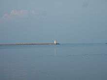
- The Harbor Beach Light is located at the end of the north breakwater entrance to the harbor of refuge, created by the U.S. Army Corps of Engineers, protecting the harbor of Harbor Beach, Michigan. Tours are available on Saturdays during the summer.
- The Harbor Beach Community House is located at the main intersection in Harbor Beach. On the west face of the building is a mural that depicts local historical scenes and figures, including representations of agriculture, Frank Murphy, shipwrecks, locomotives, and much more.
- The Grice House Museum offers a glimpse at life in the past, while preserving history for future generations.
- Frank Murphy Memorial Museum and home. The birthplace of Frank Murphy and law office of Murphy's father.
- The Harbor Beach open-air Farmers Market is open every Friday on the grounds of the historic Frank Murphy’s Museum from 2:00 P.M. until 7:00 P.M. every Friday during the summer months through October 7th.
Education
- Harbor Beach Community Schools
- Harbor Beach Elementary School
- Harbor Beach Middle School
- Harbor Beach High School
- Our Lady Of Lake Huron School
- Zion Lutheran School
Media
- The Huron County Press is a weekly paper that serves Harbor Beach and other areas of Huron County.
- The Huron Daily Tribune is a daily newspaper that covers Harbor Beach and all of Huron County.
Registered Historic Places
| National Register of Historic Places Places[15] | ||||||||||
|---|---|---|---|---|---|---|---|---|---|---|
| Historic Place | Added | Number | Address | Historic Significance | Area of Significance | Period of Significance | Owner: | Historic Function | Historic Sub-function | Current Function |
| Grice House Museum | 1982 | 82000534 | 865 N. Huron Ave., Harbor Beach | Architecture, Engineering | Politics, Government, Architecture, Industry | 1875–1899 | Local Gov't | Domestic | Single Dwelling | Museum |
| Harbor Beach Lighthouse | 1983 | 83000850 | Breakwater Entrance, Harbor Beach | Event, Architecture, Engineering | Architecture, Maritime History, Engineering, Transportation | 1875–1899 | Federal | Transportation | Water-Related | Water-Related |
| Frank Murphy Birthplace | 1971 | 71000394 | 142 S. Huron St., Harbor Beach | Frank Murphy | Social History, Politics, Government | 1875–1899 | Private, Local Government | Commerce, Trade, Domestic | Professional, Single Dwelling | Museum |
| Navigation Structures at Harbor Beach Harbor | 1997 | 97000972 | N. Lakeshore Dr., Harbor Beach | Architecture, Engineering, Event | Industry, Engineering | 1875–1899, 1900–1924, 1925–1949 | Federal | Transportation | Water-Related | Water-Related |
See also
Notes
- 1 2 "US Gazetteer files 2010". United States Census Bureau. Retrieved 2012-11-25.
- 1 2 "American FactFinder". United States Census Bureau. Retrieved 2012-11-25.
- ↑ "Population Estimates". United States Census Bureau. Retrieved 2013-06-03.
- 1 2 "American FactFinder". United States Census Bureau. Retrieved 2008-01-31.
- ↑ U.S. Geological Survey Geographic Names Information System: Harbor Beach, Michigan
- ↑ The marina at Harbor Beach
- ↑ "Annual Estimates of the Resident Population for Incorporated Places: April 1, 2010 to July 1, 2015". Retrieved July 2, 2016.
- ↑ "Census of Population and Housing". Census.gov. Retrieved June 4, 2015.
- ↑ "NowData - NOAA Online Weather Data". National Oceanic and Atmospheric Administration. Retrieved July 29, 2016.
- ↑ "MI Harbor Beach 1 SSE". National Oceanic and Atmospheric Administration. Retrieved July 29, 2016.
- ↑ Harbor Beach attractions
- ↑ "Michigan Historical Markers". michmarkers.com.
- ↑ Michigan Legal Milestones.
- ↑ "Frank Murphy". Find a Grave. Retrieved 2014-10-15.
- ↑ "National Register of Historical Places - MICHIGAN (MI), Huron County". nationalregisterofhistoricplaces.com.
External links
- Harbor Beach Chamber of Commerce.
- City of Harbor Beach website.
- Michigan DNR on Harbor Beach Harbor
- Huron County Press
- Huron Daily Tribune
- Visit Michigan's Thumb
- Harbor Beach Farmers Market
- Harbor Beach webcam, calendar and events
- Zion Lutheran School
- Our Lady of Lake Huron School
- Harbor Beach Community School
Coordinates: 43°50′41″N 82°39′05″W / 43.84472°N 82.65139°W
Municipalities and communities of Huron County, Michigan, United States | ||
|---|---|---|
| Cities | 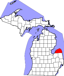 | |
| Villages | ||
| Townships | ||
| CDP | ||
| Other unincorporated communities | ||