Hennepin, Oklahoma
| Hennepin, Oklahoma | |
|---|---|
  Location within the state of Oklahoma | |
| Coordinates: 34°30′32″N 97°20′49″W / 34.50889°N 97.34694°WCoordinates: 34°30′32″N 97°20′49″W / 34.50889°N 97.34694°W | |
| Country | United States |
| State | Oklahoma |
| County | Garvin |
| Time zone | Central (CST) (UTC-6) |
| • Summer (DST) | CDT (UTC-5) |
| ZIP codes | 73444 |
Hennepin is a small unincorporated community along State Highway 7 in extreme southern Garvin County, Oklahoma, United States, near the meeting of the Carter, Garvin, and Murray county lines. The Hennepin Post Office was opened February 16, 1885, by Henry C. Dent in the old Chickasaw Nation of Indian Territory. It was named for Father Louis Hennepin, a member of Lasalle's Louisiana Expedition. The Hennepin ZIP Code is 73444.
Further reading
- Shirk, George H. "First Post Offices Within the Boundaries of Oklahoma". Chronicles of Oklahoma 26:2 (1948) 179-244. (accessed February 23, 2007)
- Shirk, George H. Oklahoma Place Names. Norman: University of Oklahoma Press, 1987. ISBN 0-8061-2028-2 .
Municipalities and communities of Garvin County, Oklahoma, United States | ||
|---|---|---|
| Cities | 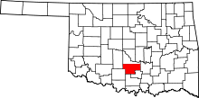 | |
| Towns | ||
| Unincorporated communities | ||
| Ghost town | ||
| Footnotes | ‡This populated place also has portions in an adjacent county or counties | |
This article is issued from Wikipedia - version of the 7/31/2016. The text is available under the Creative Commons Attribution/Share Alike but additional terms may apply for the media files.