Wallville, Oklahoma
| Wallville | |
|---|---|
| Unincorporated community | |
 Wallville  Wallville Location within the state of Oklahoma | |
| Coordinates: 34°46′05″N 97°30′14″W / 34.76806°N 97.50389°WCoordinates: 34°46′05″N 97°30′14″W / 34.76806°N 97.50389°W | |
| Country | United States |
| State | Oklahoma |
| County | Garvin |
| Time zone | Central (CST) (UTC-6) |
| • Summer (DST) | CDT (UTC-5) |
Wallville, Oklahoma is an Unincorporated community located near State Highway 76 in Garvin County, Oklahoma, United States.[1]
References
- ↑ Official State Highway Map (Map) (2005-2006 ed.). Oklahoma Department of Transportation. § K6.
Municipalities and communities of Garvin County, Oklahoma, United States | ||
|---|---|---|
| Cities | 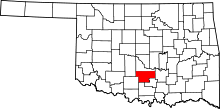 | |
| Towns | ||
| Unincorporated communities | ||
| Ghost town | ||
| Footnotes | ‡This populated place also has portions in an adjacent county or counties | |
This article is issued from Wikipedia - version of the 7/31/2016. The text is available under the Creative Commons Attribution/Share Alike but additional terms may apply for the media files.