Henry, Illinois
| Henry | |
| City | |
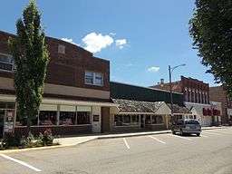 Downtown Henry | |
| Country | United States |
|---|---|
| State | Illinois |
| County | Marshall |
| Elevation | 487 ft (148 m) |
| Coordinates | 41°6′47″N 89°21′37″W / 41.11306°N 89.36028°WCoordinates: 41°6′47″N 89°21′37″W / 41.11306°N 89.36028°W |
| Area | 1.40 sq mi (4 km2) |
| - land | 1.32 sq mi (3 km2) |
| - water | 0.07 sq mi (0 km2) |
| Population | 2,464 (2010) |
| Density | 1,821.3/sq mi (703/km2) |
| Timezone | CST (UTC-6) |
| - summer (DST) | CDT (UTC-5) |
| Postal code | 61537 |
| Area code | 309 |
  Location of Henry within Illinois | |
| Wikimedia Commons: Henry, Illinois | |
| Website: henryil.com | |
Henry is a city in Marshall County, Illinois, United States. The population was 2,464 at the 2010 census. It is part of the Peoria, Illinois Metropolitan Statistical Area.
History
Henry is named after General James D. Henry, and was initially surveyed in 1834.[1] The topology of the land on the west side of the Illinois River, with relatively steep banks rising well above river level, assured early settlers that their homes would not flood.
Its slogan, "Best Town in Illinois by a Dam Site," is derived from the city's distinction of having the first lock and dam built on the Illinois River. It was completed in 1870 at a cost of $400,000.[1]
The retreat house of the Roman Catholic Diocese of Peoria, Illinois (Nazareth Retreat House, formerly, King's House) is located here.[2]
Geography
Henry is located at 41°6′47″N 89°21′37″W / 41.11306°N 89.36028°W (41.113152, -89.360218).[3]
According to the 2010 census, Henry has a total area of 1.392 square miles (3.61 km2), of which 1.32 square miles (3.42 km2) (or 94.83%) is land and 0.072 square miles (0.19 km2) (or 5.17%) is water.[4]
Demographics
| Historical population | |||
|---|---|---|---|
| Census | Pop. | %± | |
| 1850 | 400 | — | |
| 1870 | 2,162 | — | |
| 1880 | 1,728 | −20.1% | |
| 1890 | 1,512 | −12.5% | |
| 1900 | 1,637 | 8.3% | |
| 1910 | 1,687 | 3.1% | |
| 1920 | 1,637 | −3.0% | |
| 1930 | 1,658 | 1.3% | |
| 1940 | 1,877 | 13.2% | |
| 1950 | 1,966 | 4.7% | |
| 1960 | 2,278 | 15.9% | |
| 1970 | 2,610 | 14.6% | |
| 1980 | 2,740 | 5.0% | |
| 1990 | 2,591 | −5.4% | |
| 2000 | 2,540 | −2.0% | |
| 2010 | 2,464 | −3.0% | |
| Est. 2015 | 2,327 | [5] | −5.6% |
As of the census[7] of 2000, there were 2,540 people, 1,014 households, and 678 families residing in the city. The population density was 1,821.3 people per square mile (705.5/km²). There were 1,085 housing units at an average density of 778.0 per square mile (301.4/km²). The racial makeup of the city was 97.68% White, 0.51% African American, 0.20% Native American, 0.20% Asian, 0.12% from other races, and 1.30% from two or more races. Hispanic or Latino of any race were 0.63% of the population.
There were 1,014 households out of which 29.6% had children under the age of 18 living with them, 55.2% were married couples living together, 8.2% had a female householder with no husband present, and 33.1% were non-families. 29.8% of all households were made up of individuals and 16.9% had someone living alone who was 65 years of age or older. The average household size was 2.42 and the average family size was 3.00.
In the city the population was spread out with 23.9% under the age of 18, 6.9% from 18 to 24, 24.1% from 25 to 44, 23.0% from 45 to 64, and 22.1% who were 65 years of age or older. The median age was 42 years. For every 100 females there were 88.1 males. For every 100 females age 18 and over, there were 87.1 males.
The median income for a household in the city was $40,236, and the median income for a family was $50,375. Males had a median income of $39,919 versus $18,621 for females. The per capita income for the city was $18,473. About 5.7% of families and 5.6% of the population were below the poverty line, including 5.5% of those under age 18 and 6.3% of those age 65 or over.
Notable person
- John P. Cromwell, World War II submarine commander who received Medal of Honor posthumously
- Richard Widmark, Actor
References
- 1 2 History of Henry, Illinois, City of Henry official site, retrieved 2007-08-15
- ↑ http://stjosephpekin.org/weekly_bulletin/121118-WeeklyBulletin.pdf
- ↑ "US Gazetteer files: 2010, 2000, and 1990". United States Census Bureau. 2011-02-12. Retrieved 2011-04-23.
- ↑ "G001 - Geographic Identifiers - 2010 Census Summary File 1". United States Census Bureau. Retrieved 2015-12-27.
- ↑ "Annual Estimates of the Resident Population for Incorporated Places: April 1, 2010 to July 1, 2015". Retrieved July 2, 2016.
- ↑ "Census of Population and Housing". Census.gov. Retrieved June 4, 2015.
- ↑ "American FactFinder". United States Census Bureau. Retrieved 2008-01-31.
External links
Municipalities and communities of Marshall County, Illinois, United States | ||
|---|---|---|
| Cities | ||
| Villages | ||
| Townships | ||
| Unincorporated communities |
| |
| Footnotes | ‡This populated place also has portions in an adjacent county or counties | |