Highland, Ohio
| Highland, Ohio | |
|---|---|
| Village | |
 Location of Highland, Ohio | |
 Location of Highland in Highland County | |
| Coordinates: 39°20′39″N 83°35′57″W / 39.34417°N 83.59917°WCoordinates: 39°20′39″N 83°35′57″W / 39.34417°N 83.59917°W | |
| Country | United States |
| State | Ohio |
| County | Highland |
| Government | |
| • Mayor | Matthew Miller |
| Area[1] | |
| • Total | 0.17 sq mi (0.44 km2) |
| • Land | 0.17 sq mi (0.44 km2) |
| • Water | 0 sq mi (0 km2) |
| Elevation[2] | 1,063 ft (324 m) |
| Population (2010)[3] | |
| • Total | 254 |
| • Estimate (2012[4]) | 252 |
| • Density | 1,494.1/sq mi (576.9/km2) |
| Time zone | Eastern (EST) (UTC-5) |
| • Summer (DST) | EDT (UTC-4) |
| ZIP code | 45132 |
| Area code(s) | 937 |
| FIPS code | 39-35210[5] |
| GNIS feature ID | 1064836[2] |
Highland is a village in Highland County, Ohio, United States. The population was 254 at the 2010 census.
History
Highland was originally called Lexington, and under the latter name laid out in 1816.[6]
James G. Polk, a Democratic Party politician, is buried here.
Gallery
 Highland community sign
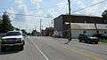 Looking east on Main Street (Ohio Highway 28) in Highland
 World War Two veterans memorial. Dedicated on November 21, 1942
Geography
Highland is located at 39°20′39″N 83°35′57″W / 39.34417°N 83.59917°W (39.344299, -83.599261).[7]
According to the United States Census Bureau, the village has a total area of 0.17 square miles (0.44 km2), all land.[1]
Demographics
| Historical population | |||
|---|---|---|---|
| Census | Pop. | %± | |
| 1880 | 139 | — | |
| 1890 | 210 | 51.1% | |
| 1900 | 265 | 26.2% | |
| 1910 | 272 | 2.6% | |
| 1920 | 235 | −13.6% | |
| 1930 | 231 | −1.7% | |
| 1940 | 262 | 13.4% | |
| 1950 | 280 | 6.9% | |
| 1960 | 265 | −5.4% | |
| 1970 | 243 | −8.3% | |
| 1980 | 284 | 16.9% | |
| 1990 | 275 | −3.2% | |
| 2000 | 283 | 2.9% | |
| 2010 | 254 | −10.2% | |
| Est. 2015 | 253 | [8] | −0.4% |
2010 census
As of the census[3] of 2010, there were 254 people, 93 households, and 65 families residing in the village. The population density was 1,494.1 inhabitants per square mile (576.9/km2). There were 105 housing units at an average density of 617.6 per square mile (238.5/km2). The racial makeup of the village was 96.5% White, 0.8% African American, 1.2% Native American, and 1.6% from two or more races. Hispanic or Latino of any race were 2.8% of the population.
There were 93 households of which 41.9% had children under the age of 18 living with them, 45.2% were married couples living together, 11.8% had a female householder with no husband present, 12.9% had a male householder with no wife present, and 30.1% were non-families. 25.8% of all households were made up of individuals and 12.9% had someone living alone who was 65 years of age or older. The average household size was 2.73 and the average family size was 3.09.
The median age in the village was 33 years. 30.3% of residents were under the age of 18; 10.3% were between the ages of 18 and 24; 24.4% were from 25 to 44; 22% were from 45 to 64; and 13% were 65 years of age or older. The gender makeup of the village was 46.9% male and 53.1% female.
2000 census
As of the census[5] of 2000, there were 283 people, 108 households, and 77 families residing in the village. The population density was 1,713.5 people per square mile (642.7/km²). There were 115 housing units at an average density of 696.3 per square mile (261.2/km²). The racial makeup of the village was 96.11% White, 0.71% African American, 0.35% from other races, and 2.83% from two or more races. Hispanic or Latino of any race were 0.35% of the population.
There were 108 households out of which 36.1% had children under the age of 18 living with them, 57.4% were married couples living together, 8.3% had a female householder with no husband present, and 28.7% were non-families. 20.4% of all households were made up of individuals and 6.5% had someone living alone who was 65 years of age or older. The average household size was 2.62 and the average family size was 3.03.
In the village the population was spread out with 25.8% under the age of 18, 11.3% from 18 to 24, 33.9% from 25 to 44, 19.8% from 45 to 64, and 9.2% who were 65 years of age or older. The median age was 33 years. For every 100 females there were 105.1 males. For every 100 females age 18 and over, there were 98.1 males.
The median income for a household in the village was $41,964, and the median income for a family was $47,500. Males had a median income of $30,000 versus $24,375 for females. The per capita income for the village was $14,005. About 5.1% of families and 10.1% of the population were below the poverty line, including 17.9% of those under the age of eighteen and 9.1% of those sixty five or over.
References
- 1 2 "US Gazetteer files 2010". United States Census Bureau. Retrieved 2013-01-06.
- 1 2 "US Board on Geographic Names". United States Geological Survey. 2007-10-25. Retrieved 2008-01-31.
- 1 2 "American FactFinder". United States Census Bureau. Retrieved 2013-01-06.
- ↑ "Population Estimates". United States Census Bureau. Retrieved 2013-06-17.
- 1 2 "American FactFinder". United States Census Bureau. Retrieved 2008-01-31.
- ↑ Overman, William Daniel (1958). Ohio Town Names. Akron, OH: Atlantic Press. p. 60.
- ↑ "US Gazetteer files: 2010, 2000, and 1990". United States Census Bureau. 2011-02-12. Retrieved 2011-04-23.
- ↑ "Annual Estimates of the Resident Population for Incorporated Places: April 1, 2010 to July 1, 2015". Retrieved July 2, 2016.
- ↑ "Census of Population and Housing". Census.gov. Retrieved June 4, 2015.
Municipalities and communities of Highland County, Ohio, United States | ||
|---|---|---|
| City | 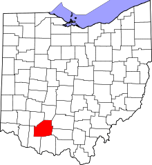 | |
| Villages | ||
| Townships | ||
| CDPs | ||
| Unincorporated communities | ||
| Footnotes | ‡This populated place also has portions in an adjacent county or counties | |