Slane
| Slane Baile Shláine | |
|---|---|
| Village | |
|
Slane Castle | |
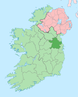
 Slane Location in Ireland | |
| Coordinates: 53°42′31″N 6°32′36″W / 53.7086°N 6.5434°WCoordinates: 53°42′31″N 6°32′36″W / 53.7086°N 6.5434°W | |
| Country | Ireland |
| Province | Leinster |
| County | County Meath |
| Elevation | 64 m (210 ft) |
| Population (2011)[1] | |
| • Village | 1,587 (2,006) |
| • Urban | 1,349 |
| • Environs | 488 |
| Irish Grid Reference | N959742 |
Slane (Irish: Baile Shláine,[2] meaning Town of Sláine mac Dela) is a village in County Meath, in Ireland. The village stands on a steep hillside on the left bank of the River Boyne at the intersection of the N2 (Dublin to Monaghan road) and the N51 (Drogheda to Navan road). In 2006 Slane's population was 1,099, having grown from 823 in 2002. The population of the village and the surrounding rural area was 1,587 in 2006, up from 1,336 in 2002.[1] The village centre dates from the 18th century. The village and surrounding area contains many historic sites dating back over 5,000 years.
The village

This village was founded by the family line of the Flanders (now Fleming). They abandoned the Estate when they emigrated to America. The village centre, laid out as a model village by the Conynghams is a good example of 18th-century town planning. At the centre of the village stand four nearly identical Georgian houses. The four houses stand at the intersection of the two main streets in the village. The four houses and four streets form an octagon. This feature is known as The Square. The two main streets in the village feature 18th century grey limestone buildings with slate roofs, oriel windows and stone steps and archways.[3] At present there is a comprehensive Village Development Plan in operation. In 2007 Meath County Council proposed that both Slane village and the mill be recognised as Architectural Conservation Areas and protected according.[4]
Transport
Bus Éireann route 190 & 190A link Slane to Navan, Trim, Athboy, Drogheda and Laytown. On weekdays there is a bus in each direction every hour to/from Navan and Drogheda.[5] The bus to Duleek was withdrawn in November 2013.[6] Collins Coaches operate a route linking Slane to Dublin, Collon, Ardee and Carrickmacross with one journey each way to/from Ballybay.[7] McConnons also serve Slane with a few services a day.[8] The Sunday only Bus Éireann route 177 providing a single journey each way via Slane on the Monaghan to Dublin route was withdrawn in November 2013.
Sport
Slane Gaelic Football Club comprises the local parish Gaelic Athletic Association Gaelic football teams for the urban and rural areas of Slane. Teams play their home games in Toddy Harding Park, located 5 kilometres (3 mi) north of the village. Slane Wanderers is the village's local football club, whose home games are played in Wheatfield Park.
The Hill of Slane

_p209_MEATH_-_CASTLE_AND_CHURCH_AT_SLANE.jpg)
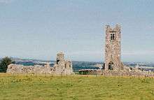
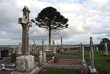
To the north of the village rises the Hill of Slane, which stands 158 metres (518 ft) above the surroundings. Such a commanding site could never have been ignored,[9] and consequently there are a number of historic sites located around the top of the hill. In the Metrical Dindshenchas, a collection of bardic verse, the ancient Fir Bolg king Sláine mac Dela was said to have been buried here, in the place that had been called Druim Fuar that came to be known in his memory Dumha Sláine.[10] There is an artificial mound on the western end of the hilltop. The hill may have been chosen as the site of Christian abbey due to the presence of an existing pagan shrine, the remains of which may be two standing stones in the burial yard.[11] Muirchu moccu Machtheni, in his highly mythologised seventh century Life of Patrick, says that St. Patrick lit a Paschal fire on this hill top in A.D. 433 in defiance of the High King Laoire who forbid any other fires while a festival fire was burning on the Hill of Tara. Historians and archaeologists agree that Muirchu has moved to Slane a fire lit elsewhere;[12] The Hill of Slane can be seen from the Hill of Tara which is about 16 kilometres (9.9 mi) away.[3][13] According to Muirchu, Logaire was so impressed by Patrick's devotion that, despite his defiance (or perhaps because of it), he let him continue his missionary work in Ireland. It is somewhat more certain that Patrick appointed a bishop of Slane, Saint Erc.
The Hill of Slane remained a centre of religion and learning for many centuries after St. Patrick. The ruins of a friary church and college can be seen on the top of the hill. It is known that Slane Friary was restored in 1512. The ruins include a 19-metre (62 ft) high early gothic tower. The friary was abandoned in 1723.[3]
The traditional Christian hymn Be Thou My Vision is set to an early medieval Irish folk song named Slane which is about the Hill of Slane.[14]
On the west side of the hill there are the remains of a twelfth-century Norman motte and bailey, built by Richard Fleming in the 1170s. This was the seat of the Flemings of Slane, barons of Slane. The Flemings moved to a castle on the left bank of the River Boyne, the current location of Slane Castle. The Flemings were lords of Slane from the twelfth century until seventeenth century, when the Conyngham family replaced them as lords of Slane during the Williamite Confiscations.[15]
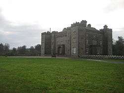
Slane Castle
Slane Castle stands on the river about 1 kilometre (0.6 mi) upstream from the centre of the village. There is an ancient well in the grounds of the castle near the river. In Irish mythology, the well was blessed by Dian Cecht so that the Tuatha Dé Danann could bathe in it and be healed, allegedly, healing all wounds but decapitation.[16] However upon the arrival of Christianity in Ireland, and the policy of Christian reinterpretation for pagan sites, the well is now known as Our lady's well.
Also in the grounds of Slane Castle(demesne) are the ruins of St. Erc's Hermitage. This consists of a late fifteenth- or early sixteenth-century chapel, an earlier dwelling,[3] a stone arched footbridge over a stream/tributary that feeds into the Boyne and the stone quarry face from where the materials for construction were taken.
The castle grounds have been the site of large rock concerts since 1981.
Annalistic references
- AI789.2 Fedach, abbot of Sláine, Lusca, and Dam Liac, rested.
Slane Mill
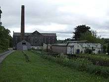
In the 1760s Boyne Navigation opened between Slane and Oldbridge, approximately 10 kilometres (6.2 mi) down river. This is a series of canals which made the River Boyne navigable to small boats from Slane to the port in Drogheda. A canal which is part of the navigation runs parallel to the river on the south bank near Slane. David Jebb was the engineer in charge of the construction. Once the navigation was opened as far as Slane Jebb himself built a flour mill at Slane.[17] Slane Mill stands on the north bank of the River Boyne beside the N2 bridge. The mill is a five-storey cut stone building. When the mill was completed in 1766 it was the largest flour mill in Ireland. The water powered mill continued to be a flour mill until the 1870s when roller mills replaced grindstones. The mill was converted to scutch flax.[18]
Slane Bridge
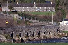

The N2 crosses the River Boyne south of the village. The road descends a steep hill from the village and makes an almost ninety degree turn onto the 14th-century bridge.[3] This bend has been the scene of at least 20 fatalities in living memory.[19] As you climb the hill towards Slane village the wall on the right hand side of the road has a number of small white crosses, each representing a death on this stretch of road. Most of the crashes have involved heavy goods vehicles which are not able to slow down sufficiently to make the sharp bend after picking up speed on the hill. Meath County Council and the National Roads Authority have installed a number of traffic calming measures over the years in an attempt to make the bend onto the bridge safer, and since their installation, fatal accidents have ceased. It was hoped that the opening of the M1 motorway would divert a lot the heavy traffic from the village but there is evidence that many heavy goods vehicles still use the N2 (and thus Slane bridge) to avoid paying the toll on the M1 bridge.[19][20]
The bridge has not always been the source of tragedy, the evening of the 18th of May 1969 is fondly remembered by many of the community when a truck laden with Bushmills and Cream of Barley Whiskey was traveling from Antrim to Dublin when its brakes failed coming down the hill and it rolled over the bridge wall into the river some 3 meters or so below, the driver survived and was brought to Hospital but the entire loot of liquor was strewn across the river bottom. Most of the town of Slane were quick on the scene, vans and truck were seen spiriting away from the wreck of the truck in the dead of night. Several prosecutions followed, the actual quantity of whiskey taken away is still known only to the management of Bushmills and perhaps to the Insurance Company that followed up the claim. The following day five Irish Divers, Brian Cusack, Sean Sheridan, Joe Murray, Fergus McKenna and Sean Donohoe arrived and while the local people of Slane were still dredging for bottles they collected 408 bottles in total, the local butcher in Slane at the time was apparently still drinking Bushmills Whiskey four years later.[21]
Near Slane
There are many other historical sites in the area around Slane. The Brú na Bóinne complex of Neolithic chamber tombs lies on the River Boyne 5 kilometres (3 mi) down river from the village. This includes Newgrange, a passage tomb built c. 3200 BC.[22]
Across the river from the old mill stand the ruins of Fennor castle/tower house, adjacent to Fennor church and its graveyard.[23][24]
The ruins of Castle Dexter which was built circa the 12th century, lay approximately 2 km west of Slane Castle and it is likewise sited near the banks of the river Boyne, 18th century drawings and watercolors of how this castle appeared are held in the National Library of Ireland.[25]
The site of the Battle of the Boyne is 10 kilometres (6.2 mi) down river, east, from Slane.
Slane Electoral Area
Slane is also the name of a Local Electoral Area encompassing a large area of eastern County Meath from Lobinstown to the Irish Sea. This area includes other towns which are actually larger than Slane such as Duleek, Stamullen and the portions of the environs of Drogheda which are in County Meath. The total population of Slane Electoral Area was 32,126 in 2006.[1][26]
Notable people
- John Cassidy (1860–1939), painter and sculptor
- Dean Cogan (1826–1872) Catholic historian, author of the The Diocese of Meath.
- John Connolly (1750–1825), second Bishop of the Roman Catholic Diocese of New York
- Francis Ledwidge (1887–1917), poet killed in action during World War I.
- John Boyle O'Reilly (1844–1890), poet, publisher, and member of the Irish Republican Brotherhood
See also
- List of towns and villages in Ireland
- List of abbeys and priories in the Republic of Ireland, (County Meath)
References
- 1 2 3 "Census 2006 – Volume 1 – Population Classified by Area" (PDF). Central Statistics Office Census 2006 Reports. Central Statistics Office Ireland. April 2007. Retrieved 24 June 2011.
- ↑ |Irish place name pronunciation.
- 1 2 3 4 5 Trench, C.E.F. (1995). Slane. An Taisce – the National Trust for Ireland. ISBN 0-903693-09-7.
- ↑ "Appendix III – Architectural Conservation Areas" (PDF). Draft Meath County Development Plan 2007–2013. Meath County Council. 2007. pp. 389–390. Retrieved 10 October 2007.
- ↑ http://buseireann.ie/pdf/1384957386-190.pdf
- ↑ http://buseireann.ie/news_timetable.php?id=1402&month=Nov
- ↑ http://www.collinscoaches.ie/index.php/dublin-commuter-service
- ↑ http://www.mcconnonsbuses.com/?p=timetable
- ↑ "From this beautiful hill, a vast prospect of Ireland is afforded on a clear day. Eastwards can easily be seen the mounds of Newgrange and Knowth, with the town of Drogheda and the Irish Sea beyond, while the view northwards extends as far as Slieve Gullion (well into Northern Ireland), southwards as far as the Sugarloaf Mountain in Wicklow, and westwards to the midlands of Ireland." (Noted at MythicalIreland.com).
- ↑ Mythical Ireland: Slane in ancient times
- ↑ Lewis, "Notes on Some Irish Antiquities" The Journal of the Anthropological Institute of Great Britain and Ireland 9 (1880:137–145) p. 142 "if such a [pagan] shrine were there, on the top of the lofty hill of Slane, it might have led to the building of the abbey: a circumstance which needs explanation, as abbeys were usually built in valleys, where land is fertile and water near at hand."
- ↑ In the syncretic fashion suggested for Tara by Alan Gailey and G. B. Adams, "The Bonfire in North Irish Tradition" Folklore 88.1 (1977:3–38) p. 13
- ↑ Rice, V.Rev. G. "The History of Christianity in Slane". Slane Historical Society. Archived from the original on 17 January 2007. Retrieved 20 May 2006.
- ↑ McKim, Lindajo H. (June 1993). The Presbyterian Hymnal Companion (1st ed.). Westminster John Knox Press. p. 340. ISBN 0-664-25180-3.
- ↑ Cokayne, George Edward. The Complete Peerage.
- ↑ Cath Maige Tuireadh. Elizabeth A. Gray (trans.)
- ↑ Wheeler, Ed (2005). "Restoring the Boyne" (PDF). Inland Waterways News. Ireland: Inland Waterways Association of Ireland. 32 (2): 20–25. ISSN 1649-1696. Retrieved 8 October 2007.
- ↑ Fitzpatrick, David & Fitzpatrick, Maureen. "The Old Mill". The Old Frequented Ways. Slane Historical and Archaeological Society.
- 1 2 Keogh, Elaine (4 July 2004). "Councillor angered at lack of progress on Slane bypass". The Irish Times. Retrieved 20 May 2006.
- ↑ Hogan, Treacy; Keogh, Elaine (29 February 2001). "Speeding trucks pose major safety risk on death bridge". The Irish Independent. Retrieved 20 May 2006. Check date values in:
|date=(help) - ↑ "The Boyne Water This article was written by Brian Cusack for a booklet commemorating the Irish Sub-aqua Club's twenty-fifth anniversary.".
- ↑ O'Kelly, Michael J. (1982). Newgrange. Thames and Hudson. ISBN 0-500-27371-5.
- ↑ FENNOR CASTLE (in it's historical context).Slane history and archaeology society
- ↑ Ryle, John. "Fennor Castle and its Historical Context". The Old Frequented Ways. Slane Historical and Archaeological Society.
- ↑ a view of Carrick Castle (or Castle Dexter), near Slane, County Meath, Ireland. drawings by Austin Cooper and watercolors by Gabriel Beranger
- ↑ "Meath Electoral Areas Map" (JPG). Meath County Council. Retrieved 3 May 2007.
External links
| Wikimedia Commons has media related to Slane. |
- Visit Slane - Slane’s Official Website
- Slane in Ancient Times
- The Boyne Valley Tourism Portal – Info on and Images of the Hill Of Slane
- Slane Tourism – information on sights, activities and accommodation in and around the village.
- Village Development Plan – developed by Slane Community Forum. This website includes many pictures of buildings in the village.
- Meath Event Guide