Hillsborough Township, New Jersey
| Hillsborough Township, New Jersey | |
|---|---|
| Township | |
| Township of Hillsborough | |
|
Township municipal complex | |
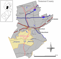 Map highlighting Hillsborough Township's location within Somerset County. Inset: Location of Somerset County in New Jersey. | |
 Census Bureau map of Hillsborough Township, New Jersey | |
| Coordinates: 40°29′52″N 74°40′14″W / 40.497692°N 74.670505°WCoordinates: 40°29′52″N 74°40′14″W / 40.497692°N 74.670505°W[1][2] | |
| Country |
|
| State |
|
| County | Somerset |
| Royal charter | September 12, 1771 |
| Incorporated | February 21, 1798 |
| Government[3] | |
| • Type | Township |
| • Body | Township Council |
| • Mayor | Frank DelCore (R, term ends December 31, 2016)[4][5] |
| • Administrator | Anthony Ferrera[6] |
| • Clerk | Pamela Borek[6] |
| Area[1] | |
| • Total | 55.001 sq mi (142.453 km2) |
| • Land | 54.536 sq mi (141.248 km2) |
| • Water | 0.465 sq mi (1.204 km2) 0.85% |
| Area rank |
29th of 566 in state 1st of 21 in county[1] |
| Elevation[7] | 108 ft (33 m) |
| Population (2010 Census)[8][9][10] | |
| • Total | 38,303 |
| • Estimate (2015)[11] | 39,821 |
| • Rank |
59th of 566 in state 3rd of 21 in county[12] |
| • Density | 702.3/sq mi (271.2/km2) |
| • Density rank |
413th of 566 in state 15th of 21 in county[12] |
| Time zone | Eastern (EST) (UTC-5) |
| • Summer (DST) | Eastern (EDT) (UTC-4) |
| ZIP code | 08844[13][14] |
| Area code(s) | 732 and 908[15] |
| FIPS code | 3403531890[1][16][17] |
| GNIS feature ID | 0882169[1][18] |
| Website |
hillsborough-nj |

Hillsborough Township is a township in Somerset County, New Jersey, United States. As of the 2010 United States Census, the township's population was 38,303,[8][9][10] reflecting an increase of 1,669 (+4.6%) from the 36,634 counted in the 2000 Census, which had in turn increased by 7,826 (+27.2%) from the 28,808 counted in the 1990 Census.[19]
Hillsborough Township was originally created by Royal charter on September 12, 1771, from portions of Western precinct. It was incorporated by an act of the New Jersey Legislature on February 21, 1798, as one of New Jersey's original group of 104 townships. Portions of the township were taken to form the boroughs of Millstone (May 14, 1894) and Manville (April 1, 1929).[20][21] The township's name may have come from an earlier name of "Hillsbury", though it may have been named for Wills Hill, 1st Marquess of Downshire who was the Earl of Hillsborough.[22]
History
On May 31, 1771, Hillsborough was officially granted a Charter incorporating it as a Township. A revised charter was issued on September 12, 1771.[20] The records of Hillsborough Township are complete from their inception in 1746 and there are ten volumes, each some several hundred pages, kept in the Special Collections Department of the Rutgers University Library along with the Charter.
Hillsborough Township quickly took its place in history as the path General George Washington and his troops traveled from the Battle of Princeton to winter quarters in Morristown. While the British were encamped in the valley below awaiting an opportunity to attack, it is said that Washington drilled his troops on the Sourland Mountain around a spring near the top using different formations and corn stalks for guns. As the sun caught the stalks, the British thought Washington had received reinforcements and fresh supplies. The British troops, thinking that they were outnumbered, slipped off to New Brunswick leaving Washington to continue to Morristown.
The township was formally incorporated on February 21, 1798.[20]
Hillsborough is the home of the Belle Mead GSA depot, or Belle Mead General Depot, which was a storage site for materials during World War II, along with housing Italian and German prisoners of war. It continued storing materials until the 1980s, and various contaminants have leaked into the ground and surrounding area during that time. Efforts are under way to convert the site into a mixed recreation and R&D complex.[23]
Hillsborough is home to Duke Gardens and Duke Farms, a 2,700 acres (11 km2) estate in the north-eastern quadrant of the town that was originally owned by tobacco and electric energy tycoon James "Buck" Duke and then passed down to daughter Doris Duke, and is now one of the few remaining "preserved" natural areas in Hillsborough Township.[24]
In Money magazine's 2013 Best Places to Live rankings, Hillsborough was ranked 16th in the nation, the third-highest among the three places in New Jersey included in the top 50 list.[25][26] In the magazine's 2007 rankings, the township was ranked as the 23rd best place to live in the nation.[27]
Geography
According to the United States Census Bureau, the township had a total area of 55.001 square miles (142.453 km2), including 54.536 square miles (141.248 km2) of land and 0.465 square miles (1.204 km2) of water (0.85%).[1][2]
Unincorporated communities, localities and place names located partially or completely within the township include Amwell, Belle Mead, Blackwells Mills, Champlain, Cloverhill, Clover Mill, Flagtown, Frankfort, Hamilton, Higgins Mills, Montgomery, Neshanic, Pleasant View, Royce Field, Royce Valley, South Branch, Woods Tavern and Zion.[28][29]
The township borders Branchburg Township, Bridgewater Township, Franklin Township, Manville, Millstone, Montgomery Township, Raritan and Somerville in Somerset County; and East Amwell Township, Raritan Township and Readington Township in Hunterdon County.[30]
Climate
| Climate data for Hillsborough Township, New Jersey | |||||||||||||
|---|---|---|---|---|---|---|---|---|---|---|---|---|---|
| Month | Jan | Feb | Mar | Apr | May | Jun | Jul | Aug | Sep | Oct | Nov | Dec | Year |
| Record high °F (°C) | 74 (23) |
76 (24) |
86 (30) |
94 (34) |
99 (37) |
101 (38) |
104 (40) |
105 (41) |
105 (41) |
92 (33) |
84 (29) |
73 (23) |
105 (41) |
| Average high °F (°C) | 38 (3) |
41 (5) |
50 (10) |
61 (16) |
72 (22) |
80 (27) |
85 (29) |
83 (28) |
76 (24) |
64 (18) |
54 (12) |
42 (6) |
62.2 (16.7) |
| Average low °F (°C) | 18 (−8) |
20 (−7) |
27 (−3) |
36 (2) |
46 (8) |
56 (13) |
61 (16) |
60 (16) |
52 (11) |
40 (4) |
31 (−1) |
23 (−5) |
39.2 (3.8) |
| Record low °F (°C) | −16 (−27) |
−12 (−24) |
−1 (−18) |
16 (−9) |
26 (−3) |
34 (1) |
44 (7) |
38 (3) |
29 (−2) |
12 (−11) |
5 (−15) |
−10 (−23) |
−16 (−27) |
| Average precipitation inches (mm) | 3.59 (91.2) |
2.84 (72.1) |
3.94 (100.1) |
4.09 (103.9) |
4.33 (110) |
4.35 (110.5) |
4.83 (122.7) |
3.98 (101.1) |
4.26 (108.2) |
4.21 (106.9) |
3.59 (91.2) |
3.84 (97.5) |
47.85 (1,215.4) |
| Source: [31] | |||||||||||||
Redevelopment
After the three and three quarter mile U.S. Route 206 Bypass is completed, the town plans to design a town center along the old Business Route 206.[32] Construction for the bypass began in 2010 and is expected to be completed by 2017, with the old section of US-206 intended to become "main street" for the township and be zoned for commercial and residential use.[33]
Demographics
| Historical population | |||
|---|---|---|---|
| Census | Pop. | %± | |
| 1790 | 2,201 | — | |
| 1810 | 2,456 | — | |
| 1820 | 2,885 | 17.5% | |
| 1830 | 2,878 | −0.2% | |
| 1840 | 2,863 | −0.5% | |
| 1850 | 3,409 | 19.1% | |
| 1860 | 3,488 | 2.3% | |
| 1870 | 3,443 | −1.3% | |
| 1880 | 3,248 | −5.7% | |
| 1890 | 2,825 | −13.0% | |
| 1900 | 2,439 | * | −13.7% |
| 1910 | 2,313 | −5.2% | |
| 1920 | 5,124 | 121.5% | |
| 1930 | 2,283 | * | −55.4% |
| 1940 | 2,645 | 15.9% | |
| 1950 | 3,875 | 46.5% | |
| 1960 | 7,584 | 95.7% | |
| 1970 | 11,061 | 45.8% | |
| 1980 | 19,061 | 72.3% | |
| 1990 | 28,808 | 51.1% | |
| 2000 | 36,634 | 27.2% | |
| 2010 | 38,303 | 4.6% | |
| Est. 2015 | 39,821 | [11][34] | 4.0% |
| Population sources: 1790-1920[35] 1840[36] 1850-1870[37] 1850[38] 1870[39] 1880-1890[40] 1890-1910[41] 1910-1930[42] 1930-1990[43] 2000[44][45] 2010[8][9][10] * = Lost territory in previous decade.[20] | |||
Census 2010
At the 2010 United States Census, there were 38,303 people, 13,573 households, and 10,424 families residing in the township. The population density was 702.3 per square mile (271.2/km2). There were 14,030 housing units at an average density of 257.3 per square mile (99.3/km2). The racial makeup of the township was 78.61% (30,109) White, 4.59% (1,757) Black or African American, 0.12% (46) Native American, 12.38% (4,743) Asian, 0.04% (15) Pacific Islander, 2.18% (834) from other races, and 2.09% (799) from two or more races. Hispanics or Latinos of any race were 7.55% (2,893) of the population.[8]
There were 13,573 households, of which 40.3% had children under the age of 18 living with them, 65.7% were married couples living together, 8.3% had a female householder with no husband present, and 23.2% were non-families. 19.0% of all households were made up of individuals, and 6.3% had someone living alone who was 65 years of age or older. The average household size was 2.81 and the average family size was 3.25.[8]
In the township, 26.4% of the population were under the age of 18, 6.5% from 18 to 24, 25.6% from 25 to 44, 32.2% from 45 to 64, and 9.3% who were 65 years of age or older. The median age was 39.9 years. For every 100 females there were 95.0 males. For every 100 females age 18 and over, there were 91.4 males.[8]
The Census Bureau's 2006-2010 American Community Survey showed that (in 2010 inflation-adjusted dollars) median household income was $105,429 (with a margin of error of +/- $2,892) and the median family income was $119,750 (+/- $2,852). Males had a median income of $81,807 (+/- $5,320) versus $52,366 (+/- $1,804) for females. The per capita income for the borough was $43,029 (+/- $1,701). About 0.8% of families and 1.6% of the population were below the poverty line, including 1.1% of those under age 18 and 4.0% of those age 65 or over.[46]
Census 2000
As of the 2000 United States Census[16] there were 36,634 people, 12,649 households, and 9,802 families residing in the township. The population density was 669.9 people per square mile (258.6/km²). There were 12,854 housing units at an average density of 235.0 per square mile (90.7/km²). The racial makeup of the township was 85.96% White, 7.31% Asian, 3.76% African American, 0.09% American Indian, 0.06% Pacific Islander, 1.28% from other races, and 1.53% from two or more races. Hispanics or Latinos of any race were 4.75% of the population.[44][45]
There were 12,649 households out of which 44.9% had children under the age of 18 living with them . said– 67.6% were married couples living together, 7.5% had a female householder with no husband present, and 22.5% were non-families. 17.8% of all households were made up of individuals, and 4.0% had someone living alone who was 65 years of age or older. The average household size was 2.88, and the average family size was 3.31.[44][45]
In the township, the population was spread out with 29.1% under the age of 18, 6.0% from 18 to 24, 34.7% from 25 to 44, 23.3% from 45 to 64, and 6.8% who were 65 years of age or older. The median age was 36 years. For every 100 females, there were 97.6 males. For every 100 females age 18 and over, there were 93.1 males.[44][45]
The median income for a household in the township was $83,290, and the median income for a family was $93,933. Males had a median income of $62,273 versus $42,052 for females. The per capita income for the township was $33,091. About 2.1% of families and 3.1% of the population were below the poverty line, including 3.6% of those under age 18 and 3.5% of those age 65 or over.[44][45]
Government
Local government
Hillsborough Township is governed under the Township Commission form of government. The five-member Township Committee is elected directly by the voters at-large in partisan elections to serve three-year terms of office on a staggered basis, with either one or two seats coming up for election each year as part of the November general election in a three-year cycle.[3][47] The mayor and deputy mayor are chosen by the Township Committee from among its members at an annual reorganization meeting, each serving a one-year term.
As of 2016, members of the Hillsborough Township Committee are Mayor Frank DelCore (R, term on committee and as mayor ends December 31, 2016), Deputy Mayor Carl Suraci (R, term on committee ends 2018; term as deputy mayor ends 2016), Greg Burchette (R, 2018), Gloria McCauley (R, 2017) and Douglas Tomson (R, 2017).[4][48][49][50][51][52]
Based on the results of a Charter Study Commission, a recommendation was listed on the November 2007 general election ballot proposing that the township adopt a Mayor-Council form of government under the Faulkner Act.[53] At the election, 58% of those voting chose to reject the proposed change, leaving Hillsborough's traditional township form of government unchanged.[54]
Federal, state and county representation
Hillsborough Township is located in the 7th Congressional District[55] and is part of New Jersey's 16th state legislative district.[9][56][57]
New Jersey's Seventh Congressional District is represented by Leonard Lance (R, Clinton Township).[58] New Jersey is represented in the United States Senate by Cory Booker (D, Newark, term ends 2021)[59] and Bob Menendez (D, Paramus, 2019).[60][61]
For the 2016–2017 session (Senate, General Assembly), the 16th Legislative District of the New Jersey Legislature is represented in the State Senate by Christopher Bateman (R, Branchburg) and in the General Assembly by Jack Ciattarelli (R, Hillsborough Township) and Andrew Zwicker (D, South Brunswick). [62] The Governor of New Jersey is Chris Christie (R, Mendham Township).[63] The Lieutenant Governor of New Jersey is Kim Guadagno (R, Monmouth Beach).[64]
Somerset County is governed by a five-member Board of Chosen Freeholders, whose members are elected at-large to three-year terms of office on a staggered basis, with one or two seats coming up for election each year. At an annual reorganization meeting held in the beginning of January, the board selects a Director and Deputy Director from among its members.[65] As of 2016, Somerset County's Freeholders are Freeholder Director Patricia L. Walsh (R, Green Brook Township, term ends December 31, 2016)[66], Freeholder Deputy Director Peter S. Palmer (R, Bernardsville, 2017),[67] Patrick Scaglione (R, Bridgewater Township, 2018),[68] Mark Caliguire (R, Skillman in Montgomery Township, 2018),[69] and Brian D. Levine (R, Franklin Township, 2017),[70] Constitutional officers elected on a countywide basis are County Clerk Brett A. Radi (R, Somerville, 2017),[71] Sheriff Frank J. Provenzano (R, Raritan, 2016)[72][73] and Surrogate Frank Bruno (R, Branchburg, 2018).[74]
Politics
As of March 23, 2011, there were a total of 24,841 registered voters in Hillsborough Township, of which 5,575 (22.4% vs. 26.0% countywide) were registered as Democrats, 5,507 (22.2% vs. 25.7%) were registered as Republicans and 13,745 (55.3% vs. 48.2%) were registered as Unaffiliated. There were 14 voters registered to other parties.[75] Among the township's 2010 Census population, 64.9% (vs. 60.4% in Somerset County) were registered to vote, including 88.1% of those ages 18 and over (vs. 80.4% countywide).[75][76]
In the 2012 presidential election, Democrat Barack Obama received 49.8% of the vote (9,071 cast), ahead of Republican Mitt Romney with 48.5% (8,842 votes), and other candidates with 1.7% (301 votes), among the 18,319 ballots cast by the township's 26,570 registered voters (105 ballots were spoiled), for a turnout of 68.9%.[77][78] In the 2008 presidential election, Democrat Barack Obama received 9,507 votes (49.8% vs. 52.1% countywide), ahead of Republican John McCain with 9,218 votes (48.2% vs. 46.1%) and other candidates with 250 votes (1.3% vs. 1.1%), among the 19,107 ballots cast by the township's 23,926 registered voters, for a turnout of 79.9% (vs. 78.7% in Somerset County).[79] In the 2004 presidential election, Republican George W. Bush received 9,246 votes (53.0% vs. 51.5% countywide), ahead of Democrat John Kerry with 7,965 votes (45.7% vs. 47.2%) and other candidates with 176 votes (1.0% vs. 0.9%), among the 17,433 ballots cast by the township's 21,152 registered voters, for a turnout of 82.4% (vs. 81.7% in the whole county).[80]
In the 2013 gubernatorial election, Republican Chris Christie received 69.2% of the vote (7,855 cast), ahead of Democrat Barbara Buono with 29.1% (3,298 votes), and other candidates with 1.7% (190 votes), among the 11,493 ballots cast by the township's 26,883 registered voters (150 ballots were spoiled), for a turnout of 42.8%.[81][82] In the 2009 gubernatorial election, Republican Chris Christie received 7,436 votes (59.9% vs. 55.8% countywide), ahead of Democrat Jon Corzine with 3,765 votes (30.3% vs. 34.1%), Independent Chris Daggett with 1,046 votes (8.4% vs. 8.7%) and other candidates with 96 votes (0.8% vs. 0.7%), among the 12,416 ballots cast by the township's 24,456 registered voters, yielding a 50.8% turnout (vs. 52.5% in the county).[83]
Education
The Hillsborough Township School District serves students in Kindergarten through twelfth grade. Students from Millstone attend the district's schools as part of a sending/receiving relationship.[84] As of the 2011-12 school year, the district's nine schools had an enrollment of 7,316 students and 611.5 classroom teachers (on an FTE basis), for a student–teacher ratio of 11.96:1.[85] Schools in the district (with 2011-12 enrollment data from the National Center for Education Statistics)[86] are six elementary schools for students in Kindergarten to fourth grade — Amsterdam Elementary School[87] (502 students), Hillsborough Elementary School[88] (524), Sunnymead Elementary School[89] (389), Triangle Elementary School[90] (419), Woodfern Elementary School[91] (383) and Woods Road Elementary School[92] (442) — Auten Road Intermediate School[93] (1,101 students; grades 5-6), Hillsborough Middle School[94] (1,135; 7-8) and Hillsborough High School[95] (2,421; 9-12).[96][97][98]
Transportation
Roads and highways
As of May 2010, the township had a total of 211.92 miles (341.05 km) of roadways, of which 185.42 miles (298.40 km) were maintained by the municipality, 19.79 miles (31.85 km) by Somerset County and 6.71 miles (10.80 km) by the New Jersey Department of Transportation.[99]
U.S. Route 206 is the main road that passes through the township. A new alignment of US 206, the 1.66-mile (2.67 km) US 206 Bypass, was completed through Hillsborough in 2015 to bypass the congested stretch of the road.[100] The road is named for Peter J. Biondi, a former Hillsborough mayor and member of the General Assembly.[101]
Main county roads that pass through are CR 514 which runs for 10.24 miles (16.48 km) through the township,[102] and CR 533.[103] Interstate 287 is outside the municipality in bordering Bridgewater and Franklin Townships. Part of the proposed routing of Interstate 95 through central New Jersey included Hillsborough; this project was ultimately canceled in the 1980s.[104]
Rail
New Jersey Transit has proposed a new West Trenton Line that would stretch for 27 miles (43 km) from the West Trenton station in Ewing Township to a connection with the Raritan Valley Line at Bridgewater Township, and from there to Newark Penn Station in Newark. The plan would include stations at both Belle Mead and Hillsborough.[105][106]
The Norfolk Southern Railway's Lehigh Line (formerly the mainline of the Lehigh Valley Railroad), runs through Hillsborough Township.
Notable people
People who were born in, residents of, or otherwise closely associated with Hillsborough Township include:
- John Bell, former radio DJ on Z100 WHTZ Elvis Duran and the Z Morning Zoo.[107]
- Brad Benson (born 1955), former New York Giants offensive lineman from 1977–1987, owner of Brad Benson Hyundai and Rainbow Run Farm.[108]
- Peter J. Biondi (1942–2011), politician who served in the New Jersey General Assembly and was Mayor of Hillsborough from 1986 to 1993.[109]
- Michael Ian Black (born 1971), actor, comedian, member of The State and Stella.[110]
- Jack Ciattarelli (born 1961), politician, member of the New Jersey General Assembly, former Somerset County Freeholder.[111]
- Jyotirmoy Datta (born 1936), Bengali writer, journalist, poet and essayist.[112]
- Doris Duke (1912–1993), heiress and philanthropist.[113]
- Jaheim (born 1978), R&B singer.[114]
- Shawn Mayer (born 1979), NFL safety who played for the New England Patriots and Cleveland Browns.[115]
- Shaun O'Hara (born 1977), NFL center who played for the New York Giants.[116]
- Ricky Proehl (born 1968), NFL wide receiver who has played for the Indianapolis Colts and is currently the wide receiver coach of the Carolina Panthers.[117][118]
- Dustin Sheppard (born 1980), MLS forward who played for the MetroStars.[119]
- Rich Vos (born 1957), comedian.[120]
- Peter Dumont Vroom (1791–1873), 9th Governor of New Jersey.[121]
References
- 1 2 3 4 5 6 2010 Census Gazetteer Files: New Jersey County Subdivisions, United States Census Bureau. Accessed May 21, 2015.
- 1 2 US Gazetteer files: 2010, 2000, and 1990, United States Census Bureau. Accessed September 4, 2014.
- 1 2 2012 New Jersey Legislative District Data Book, Rutgers University Edward J. Bloustein School of Planning and Public Policy, March 2013, p. 77.
- 1 2 Township Committee, Hillsborough Township. Accessed August 1, 2016.
- ↑ 2016 New Jersey Mayors Directory, New Jersey Department of Community Affairs. Accessed June 14, 2016.
- 1 2 Administrator/Municipal Clerk, Hillsborough Township. Accessed August 1, 2016.
- ↑ U.S. Geological Survey Geographic Names Information System: Township of Hillsborough, Geographic Names Information System. Accessed March 5, 2013.
- 1 2 3 4 5 6 DP-1 - Profile of General Population and Housing Characteristics: 2010 for Hillsborough township, Somerset County, New Jersey, United States Census Bureau. Accessed August 26, 2012.
- 1 2 3 4 Municipalities Grouped by 2011-2020 Legislative Districts, New Jersey Department of State, p. 8. Accessed January 6, 2013.
- 1 2 3 Profile of General Demographic Characteristics: 2010 for Hillsborough township, New Jersey Department of Labor and Workforce Development. Accessed August 26, 2012.
- 1 2 PEPANNRES - Annual Estimates of the Resident Population: April 1, 2010 to July 1, 2015 - 2015 Population Estimates for New Jersey municipalities, United States Census Bureau. Accessed May 22, 2016.
- 1 2 GCT-PH1 Population, Housing Units, Area, and Density: 2010 - State -- County Subdivision from the 2010 Census Summary File 1 for New Jersey, United States Census Bureau. Accessed July 31, 2013.
- ↑ Look Up a ZIP Code for Hillsborough, NJ, United States Postal Service. Accessed August 26, 2012.
- ↑ Zip Codes, State of New Jersey. Accessed September 11, 2013.
- ↑ Area Code Lookup - NPA NXX for Hillsborough, NJ, Area-Codes.com. Accessed September 11, 2013.
- 1 2 American FactFinder, United States Census Bureau. Accessed September 4, 2014.
- ↑ A Cure for the Common Codes: New Jersey, Missouri Census Data Center. Accessed August 26, 2012.
- ↑ US Board on Geographic Names, United States Geological Survey. Accessed September 4, 2014.
- ↑ Table 7. Population for the Counties and Municipalities in New Jersey: 1990, 2000 and 2010, New Jersey Department of Labor and Workforce Development, February 2011. Accessed August 26, 2012.
- 1 2 3 4 Snyder, John P. The Story of New Jersey's Civil Boundaries: 1606-1968, Bureau of Geology and Topography; Trenton, New Jersey; 1969. p. 223. Accessed August 26, 2012.
- ↑ New Jersey Local Name Search, State of New Jersey. Accessed February 17, 2014.
- ↑ Our Towns - History Of Hillsborough, Hillsborough Township. Accessed September 1, 2015. "Hillsborough's roads got their names from early records, Hillsborough was also known as Hillsbury and although the records are obscure, some believe the Township was named for Lord Hillsborough."
- ↑ Belle Mead GSA Depot, Hillsborough Township. Accessed August 26, 2012.
- ↑ Haddon, Heather. "Duke Estate Reopens; Bucolic Grounds Become Public Park, Conservation Center", Wall Street Journal, May 2, 2012. Accessed August 26, 2012. "For years here amid the gentle hills of the Raritan River valley in suburban New Jersey, a 2,740-acre estate that once provided the setting for Doris Duke's ornamental gardens has largely been kept private.Now, after years of debate about how to handle the massive plot formerly owned by one of the world's richest women, the bucolic grounds known as Duke Farms are set to open to the public May 19 and become one of the largest privately owned public spaces in the U.S., estate officials said."
- ↑ Staff. "2013 Best Places to Live; America's best small towns", CNN / Money (magazine), September 2013. Accessed August 12, 2013.
- ↑ Staff. 2013 Best Places to Live - 16. Hillsborough, NJ, CNN / Money (magazine), September 2013. Accessed August 12, 2013.
- ↑ Best Places to Live: Top 100 for 2007 – 23. Hillsborough, N.J.", Money (magazine), July 2007. Accessed August 12, 2013.
- ↑ Our Towns, Hillsborough Township. Accessed February 13, 2013. "Hillsborough is a collection of small villages, each of which has left its own imprint on the Townships history: BELLE MEAD, BLACKWELLS MILLS, FLAGTOWN, NESHANIC, SOUTH BRANCH"
- ↑ Locality Search, State of New Jersey. Accessed April 27, 2015.
- ↑ Areas touching Hillsborough Township, MapIt. Accessed April 27, 2015.
- ↑ Monthly Averages for Hillsborough, NJ (08844), Weather.com. Accessed November 17, 2011.
- ↑ Fox unveils re-designed Hillsborough Bypass: New smart growth plan reduces sprawl, preserves more open space, New Jersey Department of Transportation press release dated December 20, 2002.
- ↑ Paik, Eugene. "Hillsborough bypass plan for highway advances to next stage",The Star-Ledger, March 18, 2012. August 26, 2012. "Work has proceeded over the past year on a $110 million two-lane bypass around traffic-jammed Route 206 through Hillsborough, a 3.6-mile project nearly four decades in the making. The bypass would allow the municipality to transform the area around the currently gridlocked road into a pedestrian-friendly downtown."
- ↑ Census Estimates for New Jersey April 1, 2010 to July 1, 2015, United States Census Bureau. Accessed May 22, 2016.
- ↑ Compendium of censuses 1726-1905: together with the tabulated returns of 1905, New Jersey Department of State, 1906. Accessed July 10, 2013.
- ↑ Bowen, Francis. American Almanac and Repository of Useful Knowledge for the Year 1843, p. 231, David H. Williams, 1842. Accessed February 13, 2013.
- ↑ Raum, John O. The History of New Jersey: From Its Earliest Settlement to the Present Time, Volume 1, p. 259, J. E. Potter and company, 1877. Accessed February 13, 2013. Hillsborough township is on the Millstone river. Its population in 1850 was 3,409; in 1860, 3,488; and in 1870, 3,444."
- ↑ Debow, James Dunwoody Brownson. The Seventh Census of the United States: 1850, p. 141. R. Armstrong, 1853. Accessed February 13, 2013. Population of 3,444 is listed for 1870, which conflicts with 1870 Census data of 3,443.
- ↑ Staff. A compendium of the ninth census, 1870, p. 260. United States Census Bureau, 1872. Accessed February 13, 2013.
- ↑ Porter, Robert Percival. Preliminary Results as Contained in the Eleventh Census Bulletins: Volume III - 51 to 75, p. 99. United States Census Bureau, 1890. Accessed February 13, 2013.
- ↑ Thirteenth Census of the United States, 1910: Population by Counties and Minor Civil Divisions, 1910, 1900, 1890, United States Census Bureau, p. 338. Accessed February 13, 2013.
- ↑ Fifteenth Census of the United States : 1930 - Population Volume I, United States Census Bureau, p. 718. Accessed February 13, 2013.
- ↑ Table 6. New Jersey Resident Population by Municipality: 1930 - 1990, New Jersey Department of Labor and Workforce Development. Accessed June 28, 2015.
- 1 2 3 4 5 Census 2000 Profiles of Demographic / Social / Economic / Housing Characteristics for Hillsborough township, New Jersey, United States Census Bureau. Accessed August 26, 2012.
- 1 2 3 4 5 DP-1: Profile of General Demographic Characteristics: 2000 - Census 2000 Summary File 1 (SF 1) 100-Percent Data for Hillsborough township, Somerset County, New Jersey, United States Census Bureau. Accessed August 26, 2012.
- ↑ DP03: Selected Economic Characteristics from the 2006-2010 American Community Survey 5-Year Estimates for Hillsborough township, Somerset County, New Jersey, United States Census Bureau. Accessed August 26, 2012.
- ↑ "Forms of Municipal Government in New Jersey", p. 7. Rutgers University Center for Government Studies. Accessed June 3, 2015.
- ↑ 2016 Municipal Data Sheet, Hillsborough Township. Accessed August 1, 2016.
- ↑ Somerset County Directory 2016, Somerset County, New Jersey. Accessed July 31, 2016.
- ↑ Somerset County - General Election November 3, 2015 Winning Candidates, Somerset County, New Jersey. Accessed July 31, 2016.
- ↑ Somerset County - General Election November 4, 2014 Winning Candidates, Somerset County, New Jersey. Accessed July 31, 2016.
- ↑ Somerset County - General Election November 5, 2013 Winning Candidates, Somerset County, New Jersey. Accessed July 31, 2016.
- ↑ Charter Study Commission Report Available On Hillsborough Website, Hillsborough Township, August 15, 2007. Accessed May 26, 2011.
- ↑ "Voters Give Township Committee Form A Vote of Confidence", Hillsborough Township, November 7, 2007. Accessed May 26, 2011.
- ↑ Plan Components Report, New Jersey Redistricting Commission, December 23, 2011. Accessed January 6, 2013.
- ↑ 2016 New Jersey Citizen's Guide to Government, p. 58, New Jersey League of Women Voters. Accessed July 20, 2016.
- ↑ Districts by Number for 2011-2020, New Jersey Legislature. Accessed January 6, 2013.
- ↑ Directory of Representatives: New Jersey, United States House of Representatives. Accessed January 5, 2012.
- ↑ About Cory Booker, United States Senate. Accessed January 26, 2015. "He now owns a home and lives in Newark's Central Ward community."
- ↑ Biography of Bob Menendez, United States Senate, January 26, 2015. "He currently lives in Paramus and has two children, Alicia and Robert."
- ↑ Senators of the 114th Congress from New Jersey. United States Senate. Accessed January 26, 2015. "Booker, Cory A. - (D - NJ) Class II; Menendez, Robert - (D - NJ) Class I"
- ↑ Legislative Roster 2016-2017 Session, New Jersey Legislature. Accessed January 17, 2016.
- ↑ "About the Governor". State of New Jersey. Retrieved 2010-01-21.
- ↑ "About the Lieutenant Governor". State of New Jersey. Retrieved 2010-01-21.
- ↑ Somerset County Government: At Your Service, Somerset County, New Jersey. Accessed August 5, 2014.
- ↑ Patricia Walsh, Somerset County, New Jersey. Accessed January 18, 2016.
- ↑ Peter S. Palmer, Somerset County, New Jersey. Accessed January 18, 2016.
- ↑ Patrick Scaglione, Somerset County, New Jersey. Accessed January 18, 2016. A term-end year of 2015 is listed as of date accessed.
- ↑ Mark Caliguire, Somerset County, New Jersey. Accessed January 18, 2016. A term-end year of 2015 is listed as of date accessed.
- ↑ Brian Levine, Somerset County, New Jersey. Accessed January 18, 2016.
- ↑ Biography: Somerset County Clerk Brett A. Radi, Somerset County, New Jersey. Accessed August 5, 2014.
- ↑ Sheriff Frank J. Provenzano, Somerset County Sheriff's Office. Accessed August 5, 2014.
- ↑ Sheriff, Somerset County, New Jersey. Accessed August 5, 2014.
- ↑ Somerset County Surrogate, Somerset County, New Jersey. Accessed January 18, 2016. A term-end year of 2015 is listed as of date accessed.
- 1 2 Voter Registration Summary - Somerset, New Jersey Department of State Division of Elections, March 23, 2011. Accessed February 13, 2013.
- ↑ GCT-P7: Selected Age Groups: 2010 - State -- County Subdivision; 2010 Census Summary File 1 for New Jersey, United States Census Bureau. Accessed February 13, 2013.
- ↑ "Presidential General Election Results - November 6, 2012 - Somerset County" (PDF). New Jersey Department of Elections. March 15, 2013. Retrieved December 24, 2014.
- ↑ "Number of Registered Voters and Ballots Cast - November 6, 2012 - General Election Results - Somerset County" (PDF). New Jersey Department of Elections. March 15, 2013. Retrieved December 24, 2014.
- ↑ 2008 Presidential General Election Results: Somerset County, New Jersey Department of State Division of Elections, December 23, 2008. Accessed February 13, 2013.
- ↑ 2004 Presidential Election: Somerset County, New Jersey Department of State Division of Elections, December 13, 2004. Accessed February 13, 2013.
- ↑ "Governor - Somerset County" (PDF). New Jersey Department of Elections. January 29, 2014. Retrieved December 24, 2014.
- ↑ "Number of Registered Voters and Ballots Cast - November 5, 2013 - General Election Results - Somerset County" (PDF). New Jersey Department of Elections. January 29, 2014. Retrieved December 24, 2014.
- ↑ 2009 Governor: Somerset County, New Jersey Department of State Division of Elections, December 31, 2009. Accessed February 13, 2013.
- ↑ Somerset County School Districts-Sending/Receiving/Regional, Somerset County Superintendent of Schools. Accessed February 13, 2013. "HILLSBOROUGH / K-12 / Receives K-12 from Millstone"
- ↑ District information for Hillsborough Township School District, National Center for Education Statistics. Accessed August 22, 2014.
- ↑ School Data for the Hillsborough Township School District, National Center for Education Statistics. Accessed July 10, 2013.
- ↑ Amsterdam Elementary School, Hillsborough Township School District. Accessed July 31, 2013.
- ↑ Hillsborough Elementary School, Hillsborough Township School District. Accessed July 31, 2013.
- ↑ Sunnymead Elementary School, Hillsborough Township School District. Accessed July 31, 2013.
- ↑ Triangle Elementary School, Hillsborough Township School District. Accessed July 31, 2013.
- ↑ Woodfern Elementary School, Hillsborough Township School District. Accessed July 31, 2013.
- ↑ Woods Road Elementary School, Hillsborough Township School District. Accessed July 31, 2013.
- ↑ Auten Road Intermediate School, Hillsborough Township School District. Accessed July 31, 2013.
- ↑ Hillsborough Middle School, Hillsborough Township School District. Accessed July 31, 2013.
- ↑ Hillsborough High School, Hillsborough Township School District. Accessed July 31, 2013.
- ↑ Hillsborough Township Schools Numbers & Addresses, Hillsborough Township School District. Accessed August 22, 2014.
- ↑ New Jersey School Directory for the Hillsborough Township School District, New Jersey Department of Education. Accessed August 22, 2014.
- ↑ 2013-2014 Somerset County Public School Directory, Somerset County, New Jersey. Accessed February 2, 2015.
- ↑ Somerset County Mileage by Municipality and Jurisdiction, New Jersey Department of Transportation, May 2010. Accessed July 24, 2014.
- ↑ US 206 Bypass Straight Line Diagram, New Jersey Department of Transportation, January 2014. Accessed August 1, 2016.
- ↑ Staff. "Christie Administration opens portion of Route 206 Bypass in Hillsborough", The Messenger-Gazette, October 28, 2013. Accessed August 1, 2016. "The Christie Administration opened a portion of the Route 206 Bypass between Amwell Road and Hillsborough Road in Hillsborough, Somerset County. The bypass, championed by the late Hillsborough Mayor and Assemblyman Peter J. Biondi, will be named in his honor."
- ↑ County Route 514 Straight Line Diagram, New Jersey Department of Transportation, October 2012. Accessed August 1, 2016.
- ↑ County Route 533 Straight Line Diagram, New Jersey Department of Transportation, November 2012. Accessed August 1, 2016.
- ↑ Daigle, Michael. "Building Boom Shaped Current Bypass Project; 'Smart growth' changed the scope of the Route 206 construction.", Hillsborough Patch, April 3, 2012. Accessed August 1, 2016. "During that time, a plan surfaced to extend I-95 along a path from Trenton through Montgomery and Hillsborough to connect with I-287 in Piscataway. This was the 'Somerset Freeway,' and it soon ran into local opposition, some statewide resistance and a new factor—cost constraints. In 1980, Gov. Brendan Byrne killed the project, and in 1983, Congress removed it from the federal highway list."
- ↑ West Trenton Line, New Jersey Transit. Accessed April 27, 2015.
- ↑ Proposed Restoration of Passenger Service on the West Trenton Line - Alignment Map, New Jersey Transit. Accessed April 27, 2015.
- ↑ Deak, Mike. "Random Drug Testing to Remain at High School; With passionate remarks on both sides, BOE votes to retain controversial policy.", HillsboroughPatch, October 23, 2012. Accessed February 13, 2013. "Another township resident, former Z100 morning personality John Bell who was known as the 'Voice of Reason,' also voiced support for keeping the policy."
- ↑ Gola, Hank. "Where are they now? Former Giant Brad Benson's motor in overdrive", Daily News (New York), December 20, 2008. Accessed May 26, 2011. "Benson would play just one more year, purchasing the land for his first dealership during the 1987 season. Now Benson lives on a 40-acre farm in Hillsborough, N.J., with his wife, two sons and daughter."
- ↑ Megerian, Chris. "Assemblyman Peter J. Biondi (R-Somerset), dies at 69, days after re-election", The Star-Ledger, November 10, 2011. Accessed August 1, 2016. "Assemblyman Peter Biondi, who on Tuesday was elected to his eighth term in the state Legislature representing the 16th District covering parts of Somerset and Morris Counties, died tonight after a battle with cancer, the Assembly Republican office said.... He held multiple positions in Hillsborough, including mayor from 1986 to 1993. He later became a Somerset County freeholder, then an assemblyman."
- ↑ Condran, Ed. "STATE OF THE STATE Defunct comedy troupe morphs into Stella", Asbury Park Press, November 19, 2004. Accessed August 26, 2012. "When Michael Ian Black was coming of age in Hillsborough during the '80s, he didn't envision himself as a sketch comedy player."
- ↑ Assistant Republican Whip Jack M. Ciattarelli, New Jersey Assembly Republicans. Accessed August 1, 2016. "Ciattarelli and his wife, Melinda, have resided in Hillsborough since 1998, enrolling all four of their children in the public school system."
- ↑ Datta, Jyotirmoy. "BUDDHADEV BOSE: The first hundred years", Urharlppol, November 2008. Accessed August 22, 2014. "Datta currently lives in Hillsborough Township, New Jersey, near New York City, where he works as a journalist with Desi Talk and as the Arts & Humanities Editor for News India Times."
- ↑ via Associated Press. "DORIS DUKE, 80", The Philadelphia Inquirer, October 29, 1993. Accessed March 30, 2008. "Doris Duke, 80, the tobacco heiress whose father's fortune made her the richest girl in the world and propelled her into an international circle of celebrities, died yesterday.... Her main residence was Duke Farms in Hillsborough, N.J."
- ↑ Staff. "Police charge rhythm and blues singer Jaheim with speeding, marijuana possession in Hillsborough", The Messenger-Gazette, April 14, 2010. Accessed August 22, 2014. "The 32-year-old Hillsborough resident charged by township police in late March with speeding and marijuana possession was identified as platinum-selling rhythm and blues singer Jaheim, according to the web site theboombox.com."
- ↑ Staff. "LIONS SAFETY MAYER INJURED, WILL MISS SEASON", The Philadelphia Inquirer, August 15, 2000. Accessed March 30, 2008. "Safety Shawn Mayer, who had figured heavily in Penn State's plans this year, will miss the football season because of a knee injury suffered in practice.... The 6-foot, 197-pounder from Hillsborough, N.J., played in every game last season."
- ↑ O'Gorman, George. "Giants Stadium celebration gives Big Blue chance to celebrate at home for the first time in months", Trentonian, February 6, 2008. Accessed March 30, 2008. "For two of the Giants' three Jersey guys, the salute by their home state wasn't a surprise. 'They always do things right in New Jersey,' said center Shaun O'Hara, a Rutgers grad who grew up in Hillsborough and now lives in Rutherford."
- ↑ Player profile for Ricky Proehl, Indianapolis Colts. Accessed December 20, 2006.
- ↑ Ricky Proehl celebrates Super Bowl championship: 'It felt awesome,' ex-Hillsborough High football standout said, Princeton Packet, February 3, 2000.
- ↑ Miller, Justin. "Hillsboro's Sheppard getting shot in MLS", Courier News, August 3, 2002. Accessed July 31, 2013.
- ↑ Condran, Ed. "Rich Vos", Bucks County Courier Times, February 23, 2006. Accessed July 10, 2013. "'I'm very close with my daughters,' Vos said. 'I moved to Hillsborough to be close to them. I know comics who never see their kids. I don't get that.'"
- ↑ Peter D. Vroom, New Jersey Historical Society. Accessed December 16, 2006.
External links
- Hillsborough Township official web site
- Hillsborough Township School District
- Hillsborough Township School District's 2014–15 School Report Card from the New Jersey Department of Education
- School Data for the Hillsborough Township School District, National Center for Education Statistics
Municipalities and communities of Somerset County, New Jersey, United States | ||
|---|---|---|
| Boroughs | 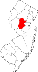 | |
| Townships | ||
| CDPs | ||
| Other unincorporated communities | ||
 |
Branchburg Township Readington Township |
Raritan Somerville Bridgewater Township |
Manville | |
| East Amwell Township | |
Franklin Township Millstone | ||
| ||||
| | ||||
| Montgomery Township |