Hollytree, Alabama
| Hollytree, Alabama | |
|---|---|
| Unincorporated community | |
 Hollytree, Alabama  Hollytree, Alabama | |
| Coordinates: 34°47′56″N 86°15′12″W / 34.79889°N 86.25333°WCoordinates: 34°47′56″N 86°15′12″W / 34.79889°N 86.25333°W | |
| Country | United States |
| State | Alabama |
| County | Jackson |
| Elevation | 669 ft (204 m) |
| Time zone | Central (CST) (UTC-6) |
| • Summer (DST) | CDT (UTC-5) |
| ZIP code | 35751 |
| Area code(s) | 256 & 938 |
| GNIS feature ID | 156488[1] |
Hollytree is an unincorporated community in Jackson County, Alabama, United States. Hollytree is located on Alabama State Route 65, 9.7 miles (15.6 km) northeast of Gurley. Hollytree has a post office with ZIP code 35751.[2][3]
References
- ↑ "Hollytree". Geographic Names Information System. United States Geological Survey.
- ↑ United States Postal Service (2012). "USPS - Look Up a ZIP Code". Retrieved 2012-02-15.
- ↑ "Postmaster Finder - Post Offices by ZIP Code". United States Postal Service. Retrieved June 4, 2013.
Municipalities and communities of Jackson County, Alabama, United States | ||
|---|---|---|
| Cities | 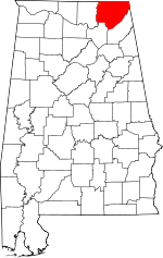 | |
| Towns | ||
| Unincorporated communities | ||
| Ghost towns | ||
This article is issued from Wikipedia - version of the 7/31/2016. The text is available under the Creative Commons Attribution/Share Alike but additional terms may apply for the media files.