Hondo, New Mexico
| Hondo | |
|---|---|
| Unincorporated community | |
 Hondo  Hondo Location within the state of New Mexico | |
| Coordinates: 33°23′30″N 105°16′29″W / 33.39167°N 105.27472°WCoordinates: 33°23′30″N 105°16′29″W / 33.39167°N 105.27472°W | |
| Country | United States |
| State | New Mexico |
| County | Lincoln |
| Elevation[1] | 5,230 ft (1,590 m) |
| Population (July 2007)[2] | |
| • Total | 1,081 |
| Time zone | Mountain (MST) (UTC-7) |
| • Summer (DST) | MDT (UTC-6) |
| ZIP codes | 88336 |
| Area code(s) | 575 |
| GNIS feature ID | 923610 |
Hondo is an unincorporated community in Lincoln County, New Mexico, United States. It is located about five miles downstream (east) from Ruidosos Downs, where the Rio Bonito and Rio Ruidoso rivers join together to form the Rio Hondo. It is located at the point where U.S. Route 70 is joined by U.S. Route 380, which conjoined route continues eastward. It has had a post office since 1900.[3]
History
The community was founded by Spanish settlers from the Rio Grande valley in the 1880s after the U.S. Army had controlled the Apache in the area. It was originally called La Junta (the junction) because of the joining of the Rio Bonito and the Rio Ruidoso.[4] Later it was called Hondo (deep) after the river.[4]
Notes
- ↑ U.S. Geological Survey Geographic Names Information System: Hondo, New Mexico
- ↑ "Hondo New Mexico" CityData
- ↑ Pearce, T. M. (1965) "Hondo" New Mexico place names; a geographical dictionary University of New Mexico Press, Albuquerque, New Mexico, p. 71, OCLC 420847
- 1 2 Julyan, Robert (1998) "Hondo" The Place Names of New Mexico (revised edition) University of New Mexico Press, Albuquerque, New Mexico, p. 169, ISBN 0-8263-1689-1
External links
- "Coe Ranch in Hondo, New Mexico" America's Byways, photograph
Municipalities and communities of Lincoln County, New Mexico, United States | ||
|---|---|---|
| City | 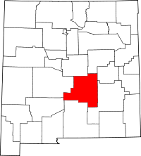 | |
| Town | ||
| Villages | ||
| CDP | ||
| Other unincorporated communities | ||
| Ghost town | ||
This article is issued from Wikipedia - version of the 8/7/2016. The text is available under the Creative Commons Attribution/Share Alike but additional terms may apply for the media files.