Huntsville, Tennessee
| Huntsville, Tennessee | |
|---|---|
| Town | |
|
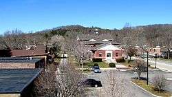
The courthouse square in Huntsville | |
 Location of Huntsville, Tennessee | |
| Coordinates: 36°24′39″N 84°29′42″W / 36.41083°N 84.49500°WCoordinates: 36°24′39″N 84°29′42″W / 36.41083°N 84.49500°W | |
| Country | United States |
| State | Tennessee |
| County | Scott |
| Founded | 1850 |
| Incorporated | 1965[1] |
| Area | |
| • Total | 3.3 sq mi (8.6 km2) |
| • Land | 3.3 sq mi (8.6 km2) |
| • Water | 0.0 sq mi (0.0 km2) |
| Elevation | 1,319 ft (402 m) |
| Population (2010)[2] | |
| • Total | 1,248 |
| • Density | 295.3/sq mi (114.0/km2) |
| Time zone | Eastern (EST) (UTC-5) |
| • Summer (DST) | EDT (UTC-4) |
| ZIP code | 37756 |
| Area code(s) | 423 |
| FIPS code | 47-36640[3] |
| GNIS feature ID | 1288766[4] |
Huntsville is a town in Scott County, Tennessee, United States. The population was 981 at the 2000 census and 1,248 at the 2010 census, showing an increase of 267. It is the county seat of Scott County.[5]
History
Huntsville was named after a long hunter known only by the surname "Hunt." This long hunter camped under a rock shelter in the mid-18th century and later moved his family to the area. When Scott County was formed in 1849, Huntsville was chosen as the county seat due to the site's central location within the new county as well as an excellent spring that flowed across the property.[6]
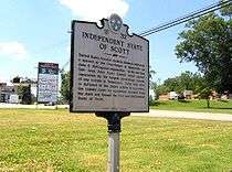
During the U.S. Civil War, Scott County was staunchly pro-Union. In Tennessee's June 1861 referendum on secession, the county voted 541-19 against secession, the highest percentage of any county in Tennessee. In spite of fierce opposition from Scott and other East Tennessee counties, the ordinance passed and Tennessee seceded from the Union. Later that year, Scott County voted unanimously to secede from Tennessee and formed the Independent State of Scott.[7][8]
In 1906, a new courthouse square was built in Huntsville using a beige-colored native sandstone for the buildings' outer walls. Although the courthouse burned in 1946, two of these sandstone buildings remain— the First National Bank building and the Old Scott County Jail.[9] Both have been placed on the National Register of Historic Places.
The Baker family, which arrived in the Huntsville area shortly after the Civil War, has been active in state and national politics for several decades. James F. Baker (1864–1934) was a successful attorney and newspaper publisher. Baker's son, Howard H. Baker, Sr. (1902–1964), was the Republican candidate for governor of Tennessee in 1938 and later served in the U.S. House of Representatives.[10] Howard H. Baker, Jr. (1925-2014), son of Howard Sr., was elected to the U.S. Senate in 1966 and gained national attention as Vice Chairman of the Senate Watergate Committee in 1973. Baker later served as Senate Majority Leader (1981–1985) and White House Chief of Staff (1987–1988).[11]
Geography
Huntsville is located at 36°24′39″N 84°29′42″W / 36.41083°N 84.49500°W (36.410732, -84.495124).[12] The town is situated atop the Cumberland Plateau at just over 10 miles (16 km) west of the plateau's eastern escarpment. Huntsville's southern boundary is located along a series of cliffs overlooking New River, approximately 15 miles (24 km) upstream from the river's mouth along the Big South Fork of the Cumberland River. Huntsville is surrounded by low mountains and hills that comprise the southern section of the Cumberland Mountains.
Huntsville's town center is situated along Tennessee State Route 63 (Howard Baker Highway), although the town's municipal boundaries stretch westward to TN-63's junction with U.S. Route 27. TN-63 intersects Interstate 75 approximately 15 miles (24 km) east of Huntsville, near the base of the Cumberland Plateau.
According to the United States Census Bureau, the town has a total area of 3.3 square miles (8.5 km2), all of it land.
Demographics
| Historical population | |||
|---|---|---|---|
| Census | Pop. | %± | |
| 1870 | 85 | — | |
| 1880 | 116 | 36.5% | |
| 1890 | 149 | 28.4% | |
| 1970 | 337 | — | |
| 1980 | 519 | 54.0% | |
| 1990 | 660 | 27.2% | |
| 2000 | 981 | 48.6% | |
| 2010 | 1,248 | 27.2% | |
| Est. 2015 | 1,233 | [13] | −1.2% |
| Sources:[14][15] | |||
As of the census[3] of 2000, there were 981 people, 406 households, and 259 families residing in the town. The population density was 295.3 people per square mile (114.1/km²). There were 441 housing units at an average density of 132.7 per square mile (51.3/km²). The racial makeup of the town was 96.94% White, 1.12% African American, 0.61% Native American, 0.10% Asian, and 1.22% from two or more races. Hispanic or Latino of any race were 0.31% of the population.

There were 406 households out of which 32.0% had children under the age of 18 living with them, 45.8% were married couples living together, 14.3% had a female householder with no husband present, and 36.0% were non-families. 33.0% of all households were made up of individuals and 13.1% had someone living alone who was 65 years of age or older. The average household size was 2.31 and the average family size was 2.94.
In the town the population was spread out with 24.8% under the age of 18, 12.1% from 18 to 24, 28.4% from 25 to 44, 23.5% from 45 to 64, and 11.1% who were 65 years of age or older. The median age was 34 years. For every 100 females there were 97.8 males. For every 100 females age 18 and over, there were 92.2 males.
The median income for a household in the town was $20,069, and the median income for a family was $25,804. Males had a median income of $26,902 versus $19,375 for females. The per capita income for the town was $16,469. About 17.2% of families and 24.1% of the population were below the poverty line, including 33.9% of those under age 18 and 16.4% of those age 65 or over.
Media
- The Independent Herald
- Hive 105, WBNT-FM
References
- ↑ Scott County: Our History. Retrieved: 22 January 2013.
- ↑ Tennessee Department of Economic and Community Development, Certified Population of Tennessee Incorporated Municipalities and Counties, State of Tennessee website, 1 July 2011.
- 1 2 "American FactFinder". United States Census Bureau. Archived from the original on September 11, 2013. Retrieved 2008-01-31.
- ↑ "US Board on Geographic Names". United States Geological Survey. 2007-10-25. Retrieved 2008-01-31.
- ↑ "Find a County". National Association of Counties. Archived from the original on May 31, 2011. Retrieved 2011-06-07.
- ↑ Esther Sharp Sanderson, County Scott and Its Mountain Folk (Nashville, Tenn.: Blue & Gray Press, 1958), 4-11.
- ↑ Sanderson, 192.
- ↑ Information obtained from Tennessee Historical Commission marker in Huntsville, 3 August 2008.
- ↑ Sanderson, 6.
- ↑ Michael Rogers, "Howard H. Baker, Sr.." The Tennessee Encyclopedia of History and Culture, 2009. Retrieved: 11 February 2013.
- ↑ Michael Rogers, "Howard H. Baker, Jr.." The Tennessee Encyclopedia of History and Culture, 2009. Retrieved: 11 February 2013.
- ↑ "US Gazetteer files: 2010, 2000, and 1990". United States Census Bureau. 2011-02-12. Retrieved 2011-04-23.
- ↑ "Annual Estimates of the Resident Population for Incorporated Places: April 1, 2010 to July 1, 2015". Retrieved July 2, 2016.
- ↑ "Census of Population and Housing: Decennial Censuses". United States Census Bureau. Retrieved 2012-03-04.
- ↑ "Incorporated Places and Minor Civil Divisions Datasets: Subcounty Resident Population Estimates: April 1, 2010 to July 1, 2012". Population Estimates. U.S. Census Bureau. Archived from the original on June 17, 2013. Retrieved 11 December 2013.
External links
Municipalities and communities of Scott County, Tennessee, United States | ||
|---|---|---|
| Towns | ||
| CDPs | ||
| Unincorporated communities | ||
| Footnotes | ‡This populated place also has portions in an adjacent county or counties | |