Wingecarribee Shire
| Wingecarribee Shire New South Wales | |||||||||||||
|---|---|---|---|---|---|---|---|---|---|---|---|---|---|
 Location in NSW | |||||||||||||
| Coordinates | 34°28′S 150°25′E / 34.467°S 150.417°ECoordinates: 34°28′S 150°25′E / 34.467°S 150.417°E | ||||||||||||
| Population | 48,028 (2015 est)[1] | ||||||||||||
| • Density | 16.5/km2 (43/sq mi) | ||||||||||||
| Established | 1 January 1981 | ||||||||||||
| Area | 2,689 km2 (1,038.2 sq mi) | ||||||||||||
| Mayor | Ken Halstead [2] | ||||||||||||
| Council seat | Moss Vale[3] | ||||||||||||
| Region | Southern Highlands, Capital Country, Illawarra | ||||||||||||
| State electorate(s) | Goulburn, Wollondilly | ||||||||||||
| Federal Division(s) | Throsby, Hume | ||||||||||||
 | |||||||||||||
| Website | Wingecarribee Shire | ||||||||||||
| |||||||||||||
Wingecarribee Shire is the local government area of the Southern Highlands in the state of New South Wales, Australia. The Wingecarribee Shire is around 110 kilometres (70 mi) southwest of the Sydney central business district and is part of regional Capital Country and to some extent can be considered part of the Southern Tablelands.
Wingecarribee Shire covers an area of 2,700 square kilometres (1,000 sq mi) that is typically referred to as the Southern Highlands. Wingecarribee Shire is an important catchment area for water supply to Sydney, Wollongong and the Northern Shoalhaven.
The Mayor of Wingecarribee Shire is Cr. Ken Halstead .[2] The Council seat and Chambers is based in Moss Vale. However, the centre of commerce of the Shire is based in Bowral.
The Shire came into existence on 1 January 1981 as an amalgamation of the three previous local government areas that made up the Southern Highlands; Mittagong Shire Council (previously Nattai Shire Council), Bowral Municipality Council and former Wingecarribee Shire (based in Moss Vale).[4]
In 2012, the Wingecarribee Shire Council won a landmark class action against Lehman Brothers Australia in the Federal Court after it was found that Lehman Brothers failed to give sound financial to the Wingecarribee Shire and other councils through exposure to high-risk investments known as collateralised debt obligations. Wingecarribee Council suffered A$21.4 million of losses on its investments. The Federal Court found that the Council was entitled to an initial award of A$9 million.[5][6][7]
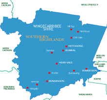
Major towns and villages
The major towns in the Shire are Mittagong, Bowral, Moss Vale, Robertson and Bundanoon.
Villages include: Balmoral Village, Hill Top, Colo Vale, Yerrinbool, Burrawang, Burradoo, Berrima, Sutton Forest, Avoca, Exeter, Wingello, Welby and Penrose.
Etymology
The current shire retains the name of the former Wingecarribee Shire because the Wingecarribee River is one of the most significant geographical features that is found in all the three previous local government areas that made up the Highlands prior to amalgamation.[4]
The word Wingecarribee is from the Dharawal language (an Indigenous Australian language) which loosely translates into "a flight of birds", or "waters to rest beside". Moreover, the term "Wingecarribee" was used as the name of the area by the first settlers of the area, the Oxley Family (See, History of Bowral) and Governor Macquarie in 1816 recorded it as "Winge Karribee". In 1838, the contemporary spelling was adapted by Surveyor Mitchell.[4]
Geology and geography
The Shire is crossed by the Hume Highway and the Southern Highlands railway line.
The pattern of development is one of small towns and villages. The eastern parts of the Shire are bounded by the Illawarra escarpment and Morton National Park, with some remnant rainforest and heathland. The north of the Shire is characterised by rugged eucalypt bushland, with gullies, gorges and sandy soils. This area forms part of the catchment for Sydney's water supply and two major storage dams (Avon and Nepean Dams) are in this area. The dams cannot be accessed by any roads within the Wingecarribee Shire but by roads leading off south-east of the Wollondilly Shire. The Wollondilly and Wingecarribee Rivers flow through the west of the Shire, through deep sandstone valleys and much of this area forms part of the catchment for Warragamba Dam. The south of the Shire is bounded by Uringalla Creek and is a sandstone plateaux dissected by deep gorges.
Wingecarribee Swamp is home to the remaining population of the endangered Giant dragonfly and Wingecarribee Leek Orchid.[8]
Demographics
Population
In 2006, the Wingecarribee Shire had an estimated population of 44,379[9] and is estimated to be growing 2.1% per annum compared to the state of New South Wales which is growing at 1.1%.[10]
The population density is 16.5 person/km2. The Shire is relatively homogenous with an Australian-born population making up 84.5% of the population. 10% of 15.5% residents born overseas are of European origin. Indigenous Australians make up 1.3% of the population. 95.5% of the population speak English at home.[11]
Workforce
The Shire's workforce is at a current estimate of 18,919 residents, around 40% of Shire's entire population.[12] The Shire's workforce are 14.7% managers, 19.3% professionals, 16.2% technicians and trades workers, 9.2% community and personal service workers, 12.5% clerical and administrative workers, 9.5% sales workers, 6.3 machinery operators and drivers, and 10.7% labourers.[13] At the 2006 census,[12] the average median income for the workforce of the Shire was $43,052. The workforce are primarily employed in four main industries: 16% in retail trading, 12% in manufacturing, 11% in health and community services, and 9% in construction.[10] The workforce predominately works within the Shire, with 77% of the workforce working within the Shire. Moreover, 3% travel to nearby Wollongong for employment and 20% work in Sydney.[10] Educationally, 40% of residents of the Shire are qualified with post High School certification in which 11% hold a University Degree and 28% qualified with a Diploma or Certificate.[10]
At the 2006 census[14] the Shire had an unemployment rate of 4.3%.
Housing and residential
Separate and detached housing make up the majority of the housing in the Shire at 91%. The rest is semi-detached/townhouse at 5% and apartments and units at 3%.[15]
Council
Current composition and election method
Wingecarribee Shire is composed of nine Councillors elected proportionally. All Councillors are elected for a fixed four-year term of office. The Mayor is elected by the Councillors at the first meeting of the Council. The most recent election was held on 10 September 2016, and the makeup of the Council is as follows:[16]
The current makeup of the council is as follows:[16]
| Party | Councillors | |
|---|---|---|
| Independents | 7 | |
| Greens | 1 | |
| Labor | 1 | |
| Total | 9 | |
The current Council, elected in 2016, in order of election, is:[16]
| Councillor | Party | Notes | |
|---|---|---|---|
| Duncan Gair | Independent | ||
| Graham McLaughlin | Labor | ||
| Grahame Andrews | Independent | ||
| Gordon Markwart | Greens | ||
| Larry Whipper | Independent | ||
| Garry Turland | Independent | ||
| Ken Halstead | Independent | Mayor | |
| Ian Scandrett | Independent | Deputy Mayor | |
| Peter Nelson | Independent | ||
Past Mayors
In 1981, the first Shire President was David Wood and the Shire Clerk was Harold Jopling.[4] Duncan Gair Gordon Lewis 2004 Dr Sara Murray 2012 Philip Yeo
Local media
Fortnightly free local newspaper, LatteLife Wingecarribee Local radio station, 102.9FM 2ST Tri-weekly paid newspaper, Southern Highland News
Local attractions
References
- ↑ "3218.0 – Regional Population Growth, Australia, 2014–15". Australian Bureau of Statistics. Retrieved 29 September 2016.
- 1 2 "Larry Whipper new Wingecarribee Mayor". Wingecarribee Shire Council. Australia. 17 September 2014. Retrieved 9 October 2014.
- ↑ "Wingecarribee Shire". Division of Local Government. Retrieved 27 November 2006.
- 1 2 3 4 "History Prior to 1981" (PDF). Wingecarribee Shire History. Wingecarribee Shire Council. Retrieved 24 September 2012.
- ↑ Johnston, Eric (22 September 2012). "Councils owed millions after Lehman Brothers 'bet', court finds". The Sydney Morning Herald. Retrieved 24 September 2012.
- ↑ O'Brien, Justin (24 September 2012). "Explaining Lehman's devastation Down Under". Business Spectator. Australia. Retrieved 24 September 2012.
- ↑ Hoerr, Karl (21 September 2012). "Lehman Brothers clients win compensation" (transcript). Lateline. Australia: ABC TV. Retrieved 24 September 2012.
- ↑ http://www.threatenedspecies.environment.nsw.gov.au/tsprofile/profile.aspx?id=10669&print=yes
- ↑ "Population". 2006 Census. Australian Bureau of Statistics.
- 1 2 3 4 http://www.southernhighlandsbusiness.com.au/shbc_region.cfm
- ↑ "Population demographics". 2006 Census. Australian Bureau of Statistics.
- 1 2 "Population". 2006 Census. Australian Bureau of Statistics.
- ↑ "Employment types". 2006 Census. Australian Bureau of Statistics.
- ↑ "Unemployment rate". 2006 Census. Australian Bureau of Statistics.
- ↑ http://www.southernhighlandsbusiness.com/demographics.html
- 1 2 3 "Wingecarribee Shire: Summary of First Preference and Group Votes for each Candidate". Local Government Elections 2016. Electoral Commission of New South Wales. 19 September 2016. Retrieved 19 October 2016.
External links
- Wingecarribee Shire website
- Official Tourism website
- Asset management information