Interstate 64 in Indiana
| ||||
|---|---|---|---|---|
_map.svg.png) | ||||
| Route information | ||||
| Maintained by INDOT | ||||
| Length: | 123.33 mi[1] (198.48 km) | |||
| Existed: | 1956 – present | |||
| Major junctions | ||||
| West end: |
| |||
|
| ||||
| East end: |
| |||
| Highway system | ||||
| ||||

Interstate 64 (I-64) in the U.S. state of Indiana is a major east–west highway providing access between Illinois and Kentucky. It passes through Indiana as part of its connection between the two metropolitan areas of St Louis, Missouri, and Louisville, Kentucky.
Route description
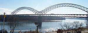
I-64 has a route through the state which travels through mostly rural areas, but the final portion of the route is encompassed by the Louisville metropolitan area. The highway enters Indiana after crossing the Wabash River from Illinois. It passes through Posey and Vanderburgh counties, where it connects with U.S. Highway 41 (US 41), and I-69 which travels south to Evansville and north to Bloomington. Continuing eastward, I-64 passes through Warrick County before straddling the Spencer–Dubois county line, which is also the boundary between the Central and the Eastern time zones.[2] It continues into and through Perry County (back in the Central Time Zone), before crossing into Crawford County where from that point on it remains in the Eastern Time Zone. This portion of the route also travels through Hoosier National Forest. Beyond the forest, the interstate travels through Harrison and Floyd counties before crossing the Sherman Minton Bridge over the Ohio River into Louisville, Kentucky.
History
I-64 was built across the eastern U.S. between St. Louis and the Hampton Roads area of Virginia in the 1960s and 70s. In Indiana, the highway was originally routed along US 50, but political influences from Evansville rerouted the highway along US 460 (since decommissioned in Indiana).[3]
Initial Construction
Like all Interstate highways in Indiana, I-64 was constructed in segments which when all were complete, made up the route we know today. There were eight segments in all, with the first to be opened being the very short segment from the Kentucky state line on the Sherman Minton Bridge to Spring Street in New Albany, which became operational on December 22, 1961. By the end of 1968, two more segments consisting of 12.94 miles (20.82 km) had opened, one near each end of the route in the state. By the end of 1972, two more segments were completed in southwestern Indiana, and I-64 was open from SR 57 (later, also I-164 and now part of the extension of I-69) north of Evansville west to the Illinois state line.[4] The three final segments of I-64 in the long stretch between SR 57 and SR 64 in Floyd County were completed later in the decade.
Subsequent Improvements and Developments
2010s
The Sherman Minton Bridge across the Ohio River was closed in 2011 after two major cracks were found.[5] However, the bridge reopened the following February after extensive repairs.[6]
Future
The Ohio River Bridges Project in the Louisville/Falls City metro area, while mainly affecting I-65 and I-265, has sparked opposition, most notably 8664.org, which calls for I-64 to be rerouted out of downtown Louisville (and, thus, the Minton Bridge) onto the planned route for I-265. They suggest the portion of I-64 between the current I-64/I-265 interchange in New Albany and its Kentucky counterpart be resigned as I-364.[7]
Exit list
| County[8] | Location[8] | mi[9] | km | Exit | Destinations[3] | Notes |
|---|---|---|---|---|---|---|
| Wabash River | 0.0 | 0.0 | ||||
| Posey | Griffin | 4.3 | 6.9 | 4 | Northern terminus of SR 69 | |
| Poseyville | 11.9 | 19.2 | 12 | |||
| Vanderburgh | Armstrong Township | 17.6 | 28.3 | 18 | ||
| Vanderburgh–Gibson county line | Scott–Johnson township line | 24.9 | 40.1 | 25 | Signed as 25A (south) and 25B (north) | |
| Gibson–Warrick county line | Johnson–Greer township line | 29.4 | 47.3 | 29 | I-69 exits 21A-B; signed as exits 29A (south) and 29B (north); Former Interstate 164; no control city northbound. | |
| Warrick | Lynnville | 39.3 | 63.2 | 39 | ||
| Pigeon Township | 53.5 | 86.1 | 54 | |||
| Spencer | Dale | 56.4 | 90.8 | 57 | Signed as exits 57A (south) and 57B (north) | |
| Dubois–Spencer county line | Ferdinand | 62.9 | 101.2 | 63 | ||
| Perry | Clark Township | 72.2 | 116.2 | 72 | ||
| Oil Township | 78.4 | 126.2 | 79 | |||
| Crawford | Union Township | 85.7 | 137.9 | 86 | Terminus of SR 237 | |
| Jennings Township | 92.0 | 148.1 | 92 | |||
| Harrison | Corydon | 105.3 | 169.5 | 105 | ||
| Franklin Township | 112.5 | 181.1 | 113 | Lanesville | ||
| Floyd | Edwardsville | 117.8 | 189.6 | 118 | Western end of SR 62 overlap; eastern terminus of SR 64 | |
| New Albany | 119.4 | 192.2 | 119 | Western end of US 150 concurrency | ||
| 121.5 | 195.5 | 121 | I-265 exit 0; eastern end of SR 62 concurrency. | |||
| 123.3 | 198.4 | 123 | New Albany | |||
| Ohio River | 123.33 | 198.48 | Sherman Minton Bridge | |||
1.000 mi = 1.609 km; 1.000 km = 0.621 mi
| ||||||
See also
 Indiana portal
 U.S. Roads portal
References
- ↑ Adderly, Kevin (January 15, 2014). "Table 1: Main Routes of the Dwight D. Eisenhower National System Of Interstate and Defense Highways as of December 31, 2013". Route Log and Finder List. Federal Highway Administration. Retrieved August 2, 2014.
- ↑ Indiana Roadway Map 2014 (PDF) (Map). Indiana Department of Transportation. Retrieved August 2, 2014.
- 1 2 "Interstate 64". AARoads. 2014. Retrieved August 2, 2014.
- ↑ Ripple, David Alan. "History of the Interstate System in Indiana", Purdue University, 1975.
- ↑ "Sherman Minton Bridge Shut Down: Cracks Found in Bridge". Louisville, KY: WDRB-TV. September 10, 2011. Retrieved August 2, 2014.
- ↑ "Sherman Minton Bridge Open". Louisville, KY: WDRB-TV. February 18, 2012. Retrieved August 2, 2014.
- ↑ 8664 Overview Presentation (Flash video). Louisville, KY: 8664.org. 2009. Retrieved August 2, 2014.
- 1 2 Staff. "I-64 from Griffin to New Albany". Interchange Book. Indiana Department of Transportation. Retrieved August 2, 2014.
- ↑ Google (August 2, 2014). "Overview Map of Interstate 64 in Indiana" (Map). Google Maps. Google. Retrieved August 2, 2014.
External links
| Previous state: Illinois |
Indiana | Next state: Kentucky |