Interstate 678
| ||||
|---|---|---|---|---|
|
Map of the New York City area with I-678 highlighted in red | ||||
| Route information | ||||
| Maintained by NYCDOT, MTAB&T, and PANYNJ | ||||
| Length: | 14.33 mi[1] (23.06 km) | |||
| Existed: | c. 1965[2][3] – present | |||
| Major junctions | ||||
| South end: |
| |||
| ||||
| North end: |
| |||
| Highway system | ||||
| ||||
.svg.png)

Interstate 678 (I-678) is a north–south auxiliary Interstate Highway that extends for 14 miles (23 km) through two boroughs of New York City. The route begins at John F. Kennedy International Airport on Jamaica Bay and travels north through Queens and across the East River to the Bronx, where it ends at the Bruckner Interchange and goes through to the Hutchinson River Parkway. I-678 connects to I-495 (the Long Island Expressway) in Flushing Meadows–Corona Park. The highway is known as the Van Wyck Expressway (/vænˈwɪk/ van-WICK[4]) from JFK Airport to Northern Boulevard (New York State Route 25A or NY 25A), the Whitestone Expressway from NY 25A north to the Bronx–Whitestone Bridge, and the Hutchinson River Expressway from the bridge to the Bruckner Interchange.
The portion of I-678 north of NY 25A follows the path of the Whitestone Parkway and a short section of the Hutchinson River Parkway's Bronx extension. Both highways were upgraded to meet Interstate Highway standards in the early 1960s and collectively designated as I-678 c. 1965. I-678 was extended southward in 1970 to follow the Van Wyck Expressway to its end at JFK Airport.
Route description
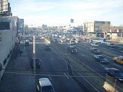
I-678 begins at John F. Kennedy International Airport in the borough of Queens. The Interstate Highway, designated the Van Wyck Expressway, progresses westward through the airport, crossing under airport runways as a six-lane freeway. Just after the runways, the expressway connects with North Service Road, which services the airport's western services. From there, the expressway begins to turn northward and crosses the United Airlines hangar. I-678 continues its northwestern progression, curving to the northeast at the interchange with Federal Circle. From there, the highway continues northward, becoming a divided highway and meeting NY 878 (the Nassau Expressway) at exit 1E. At that point AirTrain JFK begins to run parallel to the highway, overhead, until Atlantic Avenue. I-678 continues northward, crossing under the Nassau Expressway and over NY 27 east (South Conduit Avenue) and the Belt Parkway. A short distance later, the highway intersects NY 27 west (North Conduit Avenue) at exit 1B. After the interchange, the expressway continues northward through Queens, interchanging with Rockaway Boulevard and soon after Linden Boulevard. I-678 crosses and connects to Liberty Avenue and Atlantic Avenue. After entering Jamaica, the Van Wyck crosses under a major stretch of the Long Island Rail Road.[5]
Continuing northward, the expressway passes the Jamaica Hospital and intersects Jamaica Avenue at exit 6. I-678 expands to eight lanes as it crosses under Hillside Avenue (NY 25B), which is serviced by exit 6 in the opposite direction. A short distance later, the highway comes to a large interchange for NY 25 (Queens Boulevard) east at exit 8 and exit 9. After crossing under Hoover Avenue, I-678 enters the interchange with the Grand Central Parkway. In the complex interchange, the interstate crosses on overpasses over Union Turnpike, the Grand Central and different interchange ramps before returning at-grade in Flushing. There, the highway turns northwestward once again, interchanging at exit 11 with Harry Van Arsdale Junior Avenue via Park Drive East. Crossing through Flushing Meadows Corona Park, I-678 continues northward into an interchange with College Point Boulevard at exit 12A and the Long Island Expressway (I-495) at exit 12B. After the interchange with the Long Island Expressway, the Van Wyck continues northeastward. A short distance later, the expressway crosses under Roosevelt Avenue and the IRT Flushing Line of the New York City Subway. After passing Citi Field, I-678 crosses into exit 13 for NY 25A (Northern Boulevard), where the name of the freeway changes to the Whitestone Expressway.[5]
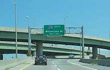
Afterwards, the Whitestone Expressway continues northward into College Point, where it intersects with Linden Place and continues northeastward past the New York Times center. A short distance later, I-678 meets 20th Avenue via its frontage road and crosses under 14th Avenue in Whitestone. Just after 14th Avenue, the highway enters exit 16, which serves the Cross Island Parkway via a left exit. After the Cross Island Parkway, the Whitestone Expressway continues now to the northwest, crossing through the Whitestone neighborhood of Queens as a six-lane freeway. After Third Avenue is serviced by exit 17, the expressway crosses Francis Lewis Park and begins its approach onto the Bronx–Whitestone Bridge over the East River. As the suspension cables on the bridge come back to the street-level, the interstate crosses from Queens into the Bronx. A short distance later, I-678 re-enters the local community, soon entering a toll booth for the bridge, widening from six to ten lanes. Afterwards, the expressway intersects Lafayette Avenue via exit 18, and soon entering the Bruckner Interchange, where I-678's designation ends and the highway continues northward as the Hutchinson River Parkway.[5]
History
The Whitestone Bridge opened on April 29, 1939, and at the same time the Whitestone Parkway, leading southwest off the bridge to Northern Boulevard (NY 25A), was opened to traffic. Work was rushed to serve the 1939 New York World's Fair, which first opened the following day.[6] At its north end, the bridge connected to Eastern Boulevard (later known as Bruckner Boulevard) by way of an extended Hutchinson River Parkway, which had ended in Pelham Bay Park prior to the early 1940s.[7][8] The portion of the Hutchinson Parkway south of Bruckner Boulevard and all of the Whitestone Parkway were converted to Interstate Highway standards in the early 1960s to allow for commercial traffic, at which time the Whitestone Parkway was renamed the Whitestone Expressway, and the aforementioned segment of the Hutchinson River Parkway was renamed the Hutchinson River Expressway.[9][10]

The Whitestone and Hutchinson River Expressways were designated as I-678 c. 1965.[2][3] Early plans for I-678 had the highway following the Astoria Expressway, a proposed freeway that would run along the NY 25A corridor from I-278 to the Grand Central Parkway.[11] This project was later cancelled. Meanwhile, the Van Wyck Expressway was built in the early 1950s to connect then-New York International Airport with the Grand Central Parkway.[12][13] The highway was built over Van Wyck Boulevard (formerly Van Wyck Avenue). The original street and the freeway were both named after former New York City Mayor Robert Anderson Van Wyck.
In the early 1960s, the Van Wyck Expressway was extended northward to meet the Whitestone Expressway at NY 25A. Work on the Van Wyck Expressway Extension, as it was originally known, began c. 1962[9][14] and was completed by the following year.[10] I-678 was extended southward over the Van Wyck Expressway to JFK Airport on January 1, 1970.[15]
While designated as a three-digit auxiliary Interstate Highway, I-678 never intersects with its ostensible "parent" interstate, I-78. Originally, I-78 would have continued eastward through New York City from its current terminus at the Holland Tunnel along the proposed Lower Manhattan Expressway and over the Williamsburg Bridge to Queens, where it would have followed the Bushwick Expressway past the southern end of I-678 to Laurelton. From here, it would have continued northward on an extended Clearview Expressway to the Bronx.[11] These plans were mostly cancelled by the late 1960s,[16] leading to the truncation of I-78 to the Brooklyn–Queens Expressway (I-278) on January 1, 1970,[15] and eventually to its current end at the east portal of the Holland Tunnel.
Exit list
| County | Location | mi[1] | km | Exit | Destinations | Notes |
|---|---|---|---|---|---|---|
| Queens | John F. Kennedy International Airport | 0.00 | 0.00 | – | ||
| A | ||||||
| B | Southbound exit only | |||||
| C | ||||||
| 1 | Exit 1 on NY 878 | |||||
| 2.00 | 3.22 | Signed as exits 1E (east) and 1W (west); exit 19 on Belt Parkway | ||||
| South Ozone Park | 2.66 | 4.28 | 2 | Rockaway Boulevard | Signed with exit 1 northbound | |
| 3 | Linden Boulevard | |||||
| 4 | Liberty Avenue | |||||
| Richmond Hill | 4.37 | 7.03 | 5 | Atlantic Avenue | ||
| 4.76 | 7.66 | 6 | Jamaica Avenue / Hillside Avenue | |||
| 7 | Southbound exit and northbound entrance; exit 7 on Jackie Robinson Parkway | |||||
| Kew Gardens | 8 | Main Street / Union Turnpike | ||||
| 5.34 | 8.59 | 9 | Southbound exit is via exit 8 | |||
| 5.87 | 9.45 | 10 | Northbound exit and southbound entrance; exit 13S on Grand Central Parkway | |||
| Flushing Meadows–Corona Park | 6.78 | 10.91 | 11 | 69th Road / Jewel Avenue – Flushing Meadows–Corona Park | ||
| 7.86 | 12.65 | 12 | Signed as exits 12A (east) and 12B (west); exits 22C–D on I-495 | |||
| Flushing | 9.28 | 14.93 | 13A | Truck route to LGA | ||
| 13B | Northbound exit and southbound entrance | |||||
| 13C | Exit 9E on Grand Central Parkway | |||||
| 13D | ||||||
| 9.43 | 15.18 | North end of Van Wyck Expressway; south end of Whitestone Expressway | ||||
| 14 | Linden Place | |||||
| 15 | 20th Avenue | |||||
| Whitestone | 16 | Northern terminus and exit 36 on Cross Island Parkway | ||||
| 17 | 3rd Avenue / 14th Avenue | No southbound entrance | ||||
| East River | 12.45 | 20.04 | Bronx–Whitestone Bridge | |||
| Bronx | Throggs Neck | 18 | Lafayette Avenue – Ferry Point Park | |||
| 19 | Northbound exit and southbound entrance; signed as exits 19N (north), 19S (south) and 19W (west); exit 6A on I-95; exit 54 on I-278 | |||||
| 14.33 | 23.06 | – | Continuation beyond Bruckner Interchange | |||
1.000 mi = 1.609 km; 1.000 km = 0.621 mi
| ||||||
See also
.svg.png) New York Roads portal
New York Roads portal
References
- 1 2 "2008 Traffic Volume Report for New York State" (PDF). New York State Department of Transportation. June 16, 2009. pp. 242–243. Retrieved July 13, 2010.
- 1 2 New York and Metropolitan New York (Map). Cartography by Rand McNally and Company. Sinclair Oil Corporation. 1964.
- 1 2 New York (Map). Cartography by Rand McNally and Company. Mobil. 1965.
- ↑ Bilefsky, Dan (May 26, 2011). "Stuck on the Van Wyck Expressway? Just Try to Pronounce It". The New York Times. p. A28. Retrieved June 20, 2012.
- 1 2 3 Microsoft; Nokia (July 14, 2010). "overview map of Interstate 678" (Map). Bing Maps. Microsoft. Retrieved July 14, 2010.
- ↑ "Whitestone Span to Open Saturday". The New York Times. April 27, 1939. p. 23. Retrieved April 4, 2010.
- ↑ New York (Map). Cartography by General Drafting. Esso. 1940.
- ↑ New York with Pictorial Guide (Map). Cartography by General Drafting. Esso. 1942.
- 1 2 New York and Metropolitan New York (Map). Cartography by Rand McNally and Company. Sinclair Oil Corporation. 1962.
- 1 2 New York Happy Motoring Guide (Map) (1963 ed.). Cartography by General Drafting. Esso. 1963.
- 1 2 New York and New Jersey Tourgide Map (Map). Cartography by Rand McNally and Company. Gulf Oil Company. 1960.
- ↑ New York (Map). Cartography by Rand McNally and Company. Socony-Vacuum Oil Company. 1950.
- ↑ New York (Map). Cartography by Rand McNally and Company. Sunoco. 1952.
- ↑ New York and Metropolitan New York (Map) (1961–62 ed.). Cartography by H.M. Gousha Company. Sunoco. 1961.
- 1 2 State of New York Department of Transportation (January 1, 1970). Official Description of Touring Routes in New York State (PDF). Retrieved July 14, 2010.
- ↑ New York State Highways (Map). Cartography by Rand McNally and Company. State of New York Department of Commerce. 1969.
External links
| Wikimedia Commons has media related to Interstate 678. |
- Interstate 678 at Alps' Roads • New York Routes
- Interstate 678 at interstate-guide.com
- Van Wyck Expressway: Historic Overview
- I-678 (Greater New York Roads)
| ||