Trans-Manhattan Expressway
| |
|---|---|
| Route information | |
| Maintained by PANYNJ | |
| Length: | 1.0 mi[1] (1.6 km) |
| Existed: | 1962 – present |
| Major junctions | |
| West end: |
|
|
| |
| East end: |
|
| Location | |
| Counties: | New York |
| Highway system | |

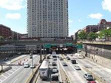
The Trans-Manhattan Expressway is an east–west limited-access highway in New York City, in the United States. It traverses the northern end of the borough of Manhattan at one of its narrowest points, running for 0.8 miles (1.3 km) in a cut through Washington Heights.[2] The highway connects the George Washington Bridge over the Hudson River to the Alexander Hamilton Bridge over the Harlem River. Designated Interstate 95 (I-95) and U.S. Route 1, approximately 280,000 vehicles traverse the highway on a daily average basis.[3] Completed in the early 1960s, the George Washington Bridge Bus Station and the high-rise Bridge Apartments built over the expressway create Intermittent tunnels. It is operated by the Port Authority of New York and New Jersey.[4]
All route numbers on the highway are north-south, though the route is east-west. The route numbers are aligned so that northbound of each route number is headed east, while southbound goes compass west.
Route description
At its western end, the Trans-Manhattan Expressway is part of I-95, U.S. Route 1 or US 1, and US 9 at the eastern approach to the George Washington Bridge. It crosses Fort Washington Park, connecting with the Henry Hudson Parkway (New York State Route 9A or NY 9A) at the park's eastern edge near Riverside Drive and 168th Street.[5] The route continues, crossing the Manhattan neighborhood of Washington Heights in a cut flanked by 178th Street to the south and 179th Street to the north. Roughly midway across Manhattan, US 9 leaves the freeway to follow Broadway northward toward the Bronx and Westchester County. Proceeding eastward, the road has several ramps that connect to the Harlem River Drive and the expressway's original Harlem river crossing, the Washington Bridge (now carrying 181st Street local traffic over the Harlem River). At Highbridge Park the roadway crosses Alexander Hamilton Bridge to the Bronx, where it becomes the Cross Bronx Expressway.
History
The Trans-Manhattan Expressway replaced tunnels under 178th and 179th Streets as the crosstown route. They are now used as storage by the Port Authority of New York and New Jersey.[6]
The expressway was announced in 1957 and built in conjunction with addition of the lower level of the George Washington Bridge.[7] Originally known as the George Washington Bridge Expressway,[8] the highway was originally planned as an open cut between 178th and 179th Streets, traversed by overpasses carrying the major north–south avenues in upper Manhattan. The City of New York approved the creation of the highway in June 1957 as part of a joint effort with the Port Authority that also called for the creation of the lower deck on the George Washington Bridge and construction of the George Washington Bridge Bus Terminal above the cut for the Expressway.[9] The Trans-Manhattan, the main New York approach to the George Washington Bridge, is only 0.8 miles long.[2] The projects required demolition of numerous buildings and the relocation of 1,824 families.[10] Overpasses over the open cut passing under Broadway, Wadsworth Avenue, and St. Nicholas Avenue were in place in December 1959.[11]
The Trans-Manhattan Expressway, with three lanes of traffic heading in each direction to and from each deck of the double-decked George Washington Bridge, opened to traffic in 1962 as part of a $60 million program to improve access roads for the George Washington Bridge, whose lower deck opened that same year.[12] The Trans-Manhattan Expressway provides access to and from the Henry Hudson Parkway and Riverside Drive on the West Side of Manhattan, and to and from Amsterdam Avenue and the Harlem River Drive on the East Side.
The expressway was one of the first to use air rights over a major highway. After completion of the expressway, the George Washington Bridge Bus Terminal was built.[4] After purchasing the air rights in 1961, Marvin Kratter built four high-rise apartment buildings over the expressway. The 32-story buildings are among the first aluminum-sheathed high-rise structures built in the world.[13] Local traffic reporters frequently refer to congestion "under the Apartments" during morning and evening rush hours.[14]
Exit list
The entire route is in the New York City borough of Manhattan.
| Location | mi[15][1] | km | Old exit | New exit | Destinations | Notes |
|---|---|---|---|---|---|---|
| Hudson River | 0.00 | 0.00 | – | – | Continuation into New Jersey; east end of US 46 | |
| George Washington Bridge | ||||||
| Washington Heights | 0.20– 0.40 | 0.32– 0.64 | – | 1 | North end of concurrency with US 9; no southbound exit | |
| – | 1A | Southbound exit and entrance from local lanes; exit 14 on NY 9A / H.H. Parkway | ||||
| 0.40– 0.80 | 0.64– 1.29 | Tunnel underneath Bus Station and Apartments | ||||
| 0.80 | 1.29 | 1B | 2 | Northbound exit and southbound entrance; exit 24 on H.R. Drive | ||
| 1.00 | 1.61 | Northern terminus of express/local lane setup | ||||
| Harlem River | Alexander Hamilton Bridge | |||||
| – | – | Continuation into the Bronx | ||||
1.000 mi = 1.609 km; 1.000 km = 0.621 mi
| ||||||
See also
-
.svg.png) New York Roads portal
New York Roads portal
References
- 1 2 Google (January 9, 2016). "Trans-Manhattan Expressway" (Map). Google Maps. Google. Retrieved January 9, 2016.
- 1 2 Heller, Susan; Dunlap, David W. (August 25, 1986). "New York Day By Day; Big Name And Short Road". The New York Times. Retrieved 2014-05-22.
- ↑ "New York State Department of Transportation Traffic Volume Report 2011 - Page 80" (PDF). September 25, 2012. Retrieved September 22, 2013.
- 1 2 "6.12: Roadway Open Cuts: 6.12: Roadway Open Manhattan" (PDF). www.nyc.gov. Archived from the original (PDF) on 2016-03-04. Retrieved 2015-02-10.
- ↑ See photos on Google Streets here and here
- ↑ Anderson, Steve. "Trans-Manhattan Expressway (I-95, US 1 and US 9)". NYCRoads. Retrieved February 6, 2012.
- ↑ Ingraham, Joseph C. (February 18, 1957). "New Bridge Links Planned Uptown; Double Decking of George Washington Span to Bring Vast Changes in Area". The New York Times. p. 1. Retrieved 2014-05-22.
- ↑ Ingraham, Joseph C. (January 1, 1961). "Around the Town: New York City's System of Bypasses is Beginning to Take Shape". The New York Times. p. X17. Retrieved April 4, 2010.
- ↑ Bennett, Charles G. (June 14, 1957). "City Votes Change in Hudson Bridge - Port Agency Gets Go-Ahead for $183,000,000 Work on George Washington Span". The New York Times. p. 1. Retrieved December 3, 2008.
- ↑ Ingraham, Joseph C. (April 23, 1959). "Relocation Is Almost Completed Near George Washington Bridge". The New York Times. p. 33. Retrieved 2014-05-22.
- ↑ "Streets to be Raised - Girders to Be Placed Today to Span Bridge Approach". The New York Times. December 14, 1959. p. 38. Retrieved 2014-05-22.
- ↑ Ingraham, Joseph C. (August 30, 1962). "Lower Deck of George Washington Bridge Is Opened". The New York Times. p. 1. Retrieved April 4, 2010.
- ↑ Nick Ravo (December 9, 1999). "Marvin Kratter, 84; Once Owned Ebbets Field". The New York Times. Retrieved 2010-03-14.
- ↑ Chen, David (June 18, 2004). "Life on the Road - Learning to Sleep as Trucks Roar Through Basement". The New York Times. Retrieved 2015-02-21.
- ↑ "2007 Traffic Data Report for New York State" (PDF). New York State Department of Transportation. July 25, 2008. Retrieved July 17, 2009.