Iowa Highway 2
| ||||
|---|---|---|---|---|
|
Iowa 2 highlighted in red | ||||
| Route information | ||||
| Maintained by Iowa DOT | ||||
| Length: | 251.376 mi[1] (404.550 km) | |||
| Major junctions | ||||
| West end: |
| |||
| ||||
| East end: |
| |||
| Location | ||||
| Counties: | ||||
| Highway system | ||||
| ||||

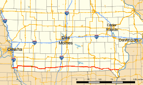
Iowa Highway 2 (Iowa 2) is a 251-mile-long (404 km) state highway which runs across the southernmost tier of counties in the U.S. state of Iowa. At no point along its route is Iowa 2 more than 15 miles (24 km) from the Missouri state line, except for a small section near its eastern terminus. Iowa 2 stretches across the entire state; from the Missouri River near Nebraska City, Nebraska, to U.S. Route 61 (US 61) at Fort Madison. Prior to becoming a primary highway, the route was known as the Waubonsie Trail.
Route description
Iowa Highway 2 begins at the Nebraska City Bridge just east of Nebraska City, Nebraska. It goes northeast and then east as an expressway until meeting Interstate 29. It then continues east as a two-lane highway until meeting U.S. Highway 275 and turning north. It continues north, bypassing Sidney with U.S. 275, and turning east of Sidney. It goes east and meets U.S. 59 at Shenandoah and then U.S. 71 at Clarinda, which is served with Business Route 2. It continues east through New Market and meets Iowa Highway 148 at Bedford. After intersecting Iowa Highway 25 east of Bedford, it passes through Benton before beginning an overlap with U.S. Highway 169 through Mount Ayr. After passing through Kellerton, Iowa 2 intersects Interstate 35 at Decatur City.
Iowa Highway 2 continues east through Decatur City and meets U.S. Highway 69 in Leon. It continues east and intersects U.S. Highway 65 before entering Corydon, where it intersects Iowa Highway 14. After passing through Promise City, it goes through Centerville, where it intersects Iowa Highway 5. It later intersects Iowa Highway 202 near Moulton and then begins a concurrency with U.S. Highway 63 which ends in Bloomfield.
After Bloomfield, Iowa Highway 2 turns southeasterly to pass through Pulaski, Milton, and Cantril, then turns briefly northeast. It turns east, intersects Iowa Highway 1 south of Keosauqua, then turns southeast towards Farmington. At Farmington, Iowa 2 meets Iowa Highway 81 and crosses the Des Moines River. It continues east and meets U.S. Highway 218 and Iowa Highway 27 at Donnellson. From there, it then meets U.S. Highway 61 and ends on the west side of Fort Madison.
Clarinda business loop
| |
|---|---|
| Location: | Clarinda |
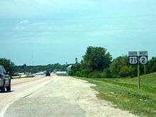
Iowa Highway 2 Business begins at the western edge of Clarinda on an old alignment of Iowa 2. It follows State Street east into Clarinda. At 16th Street (Glenn Miller Avenue), IA 2 Bus. heads south until its junction with US 71 Business. Both routes follow Washington Street east towards US 71. Iowa 2 Business follows US 71 south to IA 2 to complete the business loop.
History
The current Iowa Highway 2 was designated in 1920 as Primary Road No. 3 (PR No. 3). The 285-mile-long (459 km) route connected Nebraska City, Nebraska, to Burlington. PR No. 3 was overlaid upon the Waubonsie Trail from the Missouri River to Fort Madison. From Fort Madison, it overlappped the Mississippi Valley Scenic Highway, a precursor to the Great River Road.[2] By 1947, the route had been renumbered Iowa 2 and the section between Fort Madison and Burlington was no longer part of the route.[3]
The segment west of Interstate 29 was constructed as an expressway in 1986 with the plan of connecting Lincoln, Nebraska with Interstate 29 using a divided highway.
In late 2013, the Fort Madison city council accepted the jurisdiction of Iowa 2 within the city limits, which eliminated the last 5.8 miles (9.3 km) from the route.[4][5]
Major intersections
| County | Location | mi | km | Destinations | Notes |
|---|---|---|---|---|---|
| Otoe | Nebraska City | Continuation into Nebraska | |||
| Missouri River | 0.000 | 0.000 | Nebraska City Bridge | ||
| Fremont | Benton Township | 3.215 | 5.174 | Exit 10 on I-29 | |
| Washington–Sidney township line | 10.580 | 17.027 | West end of US 275 overlap | ||
| Sidney Township | 15.301 | 24.625 | East end of US 275 overlap | ||
| Fremont–Page county line | Shenandoah | 28.074 | 45.181 | ||
| Page | Clarinda | 45.071 | 72.535 | ||
| 46.909 | 75.493 | West end of US 71 overlap | |||
| Nodaway Township | 48.619 | 78.245 | East end of US 71 overlap | ||
| Taylor | Bedford | 65.725 | 105.774 | West end of Iowa 148 overlap | |
| 65.948 | 106.133 | East end of Iowa 148 overlap | |||
| Taylor–Ringgold county line | Gay–Benton township line | 81.833 | 131.697 | ||
| Ringgold | Rice Township | 92.486 | 148.842 | West end of US 169 overlap | |
| Mount Ayr | 94.826 | 152.608 | East end of US 169 overlap | ||
| Decatur | Decatur Township | 115.316 | 185.583 | Exit 12 on I-35 | |
| Leon | 119.648 | 192.555 | West end of US 69 overlap | ||
| 120.334 | 193.659 | East end of US 69 overlap | |||
| Wayne | Clay Township | 133.695 | 215.161 | ||
| Corydon | 143.285 | 230.595 | |||
| Appanoose | Centerville | 167.278 | 269.208 | ||
| Washington Township | 177.847 | 286.217 | |||
| Davis | West Grove Township | 187.017 | 300.975 | West end of US 63 overlap | |
| Bloomfield | 191.877 | 308.796 | East end of US 63 overlap | ||
| Van Buren | Des Moines–Vernon township line | 219.192 | 352.755 | ||
| Farmington Township | 231.268 | 372.190 | |||
| Lee | Donnellson | 242.784 | 390.723 | Interchange; exit 19 on Ave. of the Saints | |
| Fort Madison | 251.376 | 404.550 | Interchange; eastern terminus; exit 18 on US 61; road continues as US 61 Bus. (Avenue O) | ||
1.000 mi = 1.609 km; 1.000 km = 0.621 mi
| |||||
References
- ↑ "2012 Volume of Traffic on the Primary Road System of Iowa" (PDF). Iowa Department of Transportation. January 1, 2012. Retrieved January 14, 2014.
- ↑ Official Auto Trails Map (Map). 1:1,081,344. Rand McNally. 1921. p. 330-331.
- ↑ Road and Reference Atlas (Map). 1:1,077,120. Rand McNally & Company. 1947. p. 42–43.
- ↑ "City Council Minutes" (PDF). City of Fort Madison. October 1, 2013. Retrieved January 14, 2014.
- ↑ Iowa Transportation Commission (November 12, 2013). "Commission Meeting Minutes" (PDF). Iowa Department of Transportation. Retrieved January 14, 2014.
External links
- The Iowa Highways Page by Jason Hancock