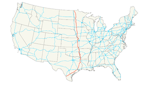
U.S. Route 59
| |
|---|---|
 | |
| Route information | |
| Length: | 1,911 mi[1] (3,075 km) |
| Existed: | 1934[1] – present |
| Major junctions | |
| South end: |
|
| |
| North end: |
|
| Location | |
| States: | Texas, Arkansas, Oklahoma, Kansas, Missouri, Iowa, Minnesota |
| Highway system | |

U.S. Route 59 is a north–south United States highway (though it is signed east–west in parts of Texas). A latecomer to the U.S. numbered route system, US 59 is now a border-to-border route, part of NAFTA Corridor Highway System. It parallels U.S. Route 75 for nearly its entire route, never much more than 100 miles (160 km) away, until it veers southwest in Houston, Texas. Its number is out of place since US 59 is either concurrent with or entirely west of U.S. Route 71.
The highway's northern terminus is nine miles (14 km) north of Lancaster, Minnesota, at the Canada–US border, where it continues as Manitoba Highway 59. Its southern terminus is at the Mexico–US border in Laredo, Texas, where it continues as Mexican Federal Highway 85D.
Route description
Texas
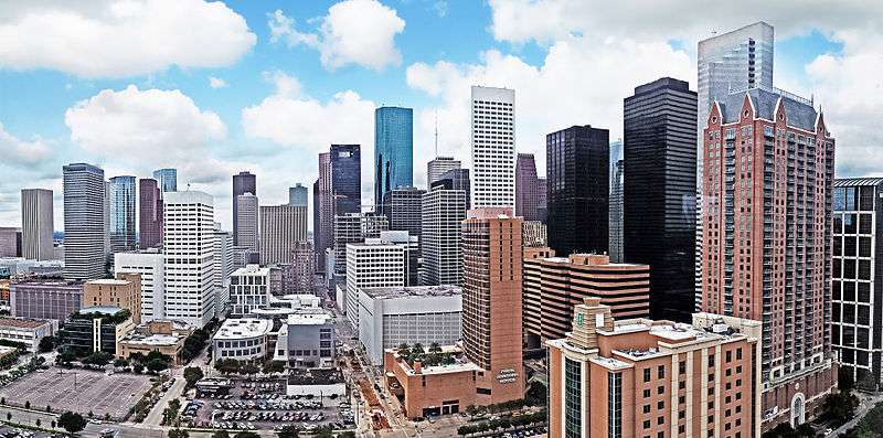
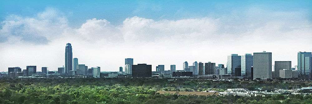
U.S. Highway 59 (US 59) in the U.S. state of Texas is named the Lloyd Bentsen Highway, after Lloyd Bentsen, former U.S. Senator from Texas. In northern Houston, US 59, co-signed with Interstate 69 (I-69), is the Eastex Freeway (from Downtown Houston to the Liberty County/Montgomery County line). To the south, which is also co-signed with I-69, it is the Southwest Freeway (from Rosenberg to Downtown Houston), which is one of the busiest sections of freeway in the United States with a vehicle count, as of 2006, over 330,000 vehicles per day just outside the Loop.[2]
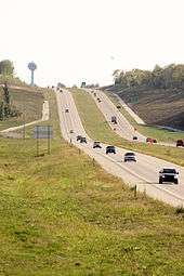
US 59 (overlapped by US 71) actually straddles the border between Texas and Arkansas north of I-30 near Texarkana, with the east side of the highway on the Arkansas side and the west side of the highway on the Texas side. In the past, both highways remained on the border past I-30 as State Line Avenue to downtown Texarkana; today, only US 71 does so. Nearly 90% of this route is designated to become part of I-69 in the future. Currently 75 mph (120 km/h) speed limits are allowed on US 59 in Duval County and portions of northern Polk County.

From the southwestern suburbs of Houston to Downtown Houston, U.S. 59 is commonly referred to as the "Southwest Freeway," sometimes derisively as the "Southwest's Best Freeway." Supporting 371,000 vehicles per day,[3] it is one of the busiest freeways in the United States. U.S. 59 is known as the "Eastex Freeway" in the north/northeast part of the Houston region. At the Mexico–US border, it ends at the World Trade International Bridge in Laredo, Texas. In Laredo, U.S. 59 is co-signed with both Interstate 69W (I-69W) and Loop 20 and has an intersection with Interstate 35 which ends at the Juarez-Lincoln International Bridge. After crossing the bridge into Mexico, Interstate 35 continues as Mexican Federal Highway 85 in Nuevo Laredo which then runs through Mexico and Central America and ends in Panama at the Panama Canal.
Arkansas
In Arkansas, US 59 is concurrent with U.S. Route 71 from Interstate 30 at Texarkana to Acorn, and with U.S. Route 270 from Acorn to the Oklahoma state line. The Third Loop was to be Extended on Interstate 49 from its original northern end to US-71 at the Texas state line opened on May 15, 2013 and was extended to State Line Road, where it intersects US-59 and US-71 in Texas.
Oklahoma
US 59 and U.S. Route 412 are co-signed for 10 miles (16 km) in Delaware County, Oklahoma.
US 59 is co-signed with U.S. Route 270 from the Arkansas State Line to Heavener and U.S. Route 271 from Poteau to west of Spiro. It is also co-signed with U.S. Route 64 in Sallisaw.
Kansas
U.S. 59 enters the state just south of Chetopa and runs nearly directly north across the state. U.S. 59 runs concurrently with U.S. 169 starting about four miles (6.4 km) south of Garnett and diverges north again immediately south of Garnett. The intersection immediately south of Garnett used to be a "braided" intersection with stop and yield signs. It was identified as a high crash location in 2001, and was rebuilt as a roundabout that opened in April 2006.[4] The Kansas Department of Transportation is rebuilding or planning to rebuild several other rural intersections as roundabouts for increased safety.[5][6] US 59 passes through Lawrence. The street name of US 59 in Lawrence is Iowa Street, then 6th Street as it joins U.S. 40 and jogs east to cross the Kansas River near downtown. North of the U.S. 40 and 59 Bridges, it splits with U.S. 40 as it joins U.S. 24 briefly and jogs back west before resuming a northerly course. It continues north to Nortonville, then northeast to Atchison, where it crosses the Missouri River over the Amelia Earhart Bridge.
U.S. 59 has been rebuilt and rerouted just to the east between Lawrence and Ottawa as a divided highway, as the former road was one of the most dangerous stretches of highway in the state. The project began in mid 2007 and was completed and opened to the public on October 17, 2012.[7]
Missouri
In Missouri, US 59 roughly follows the Missouri River in the northwest corner of the state, from its entrance at Winthrop. In Saint Joseph the highway is paired with Interstate 229 through downtown. US 59 departs from I-229 as Saint Joseph Avenue, joining with U.S. Route 71 at Interstate 29. The two highways then separate in Savannah. US 59 then follows Interstate 29 very closely until turning northward at Craig. It exits the state 10 miles (16 km) north of Tarkio. This section of US 59 is immortalized in the Brewer and Shipley song "Tarkio Road".
Iowa
In Iowa, US 59 is a main north–south artery in the western part of the state. It enters Iowa south of Shenandoah and junctions Interstate 80 at Avoca. It passes through the county seats of Harlan, Denison, Cherokee, and Primghar. Except for small stretches of expressway near Avoca, Denison, and Holstein, the entire length of US 59 in Iowa is an undivided two-lane road. US 59 exits the state near Hawkeye Point, the highest point in the state of Iowa.
Minnesota
US 59 enters Minnesota south of Worthington, just one mile (1.6 km) east of Bigelow. It passes through rural western Minnesota for its entire length in the state. Some cities along the way include Slayton, Marshall, Clarkfield, Montevideo, and Morris. US 59 overlaps Interstate 94 in the Fergus Falls area. North of Fergus Falls, US 59 passes through Pelican Rapids, Detroit Lakes and Thief River Falls before ending at the Canada–US border north of Lancaster. US-59 runs for approximately 425 miles (684 km) through Minnesota.
The Minnesota section of US 59 is legally defined as all or part of Routes 265, 16, 17, 88, 66, 144, 3, 30, and 174 in Minnesota Statutes §§ 161.115(19), (75), and (196) and 161.114(2).[8][9]
History

In 1934, a coalition of government officials from Missouri, Iowa, and Minnesota agreed to sign the current US 59 as Highway 73 in an attempt to extend US 73 north from Atchison, Kansas. However, AASHO approved the route as US 59 instead.
The part in Missouri was defined in 1922 as Route 52 from Kansas to St. Joseph, Route 1 from St. Joseph to Tarkio, and Route 61 from Tarkio to Iowa. Route 61 became Route 9 in 1926, and Route 52 became part of Route 4 in the late 1920s, before being removed in favor of US 59 in the 1930s.
Historic termini
Before the 1960s, US 59 headed northwest to US 75, crossed the Red River of the North at St. Vincent and terminated at US 81 in Pembina, North Dakota. A new highway and border crossing was built north of Lancaster on the present alignment. The former segment of US 59 between Lancaster and US 75 became CR 6, and the extremely short segment between US 75 and US 81 became MN 171 and ND 59. ND 59 still exists in Pembina from the state line to I-29.
From 1934 to 1935, the US 59 designation referred to a 50-mile (80 km)-long route across southeastern Minnesota, from Lake City, Minnesota, to the Iowa state line just short of Chester, Iowa. That entire route is now part of US 63, and nowhere close to the present US 59, established in 1935.[1]
Future
A large portion of US 59 is proposed to become part of the future extension of Interstate 69 through Texas, allowing the current alignment and right-of-way to be upgraded without the need for extensive eminent domain proceedings.[10]
Major intersections
- Texas
- World Trade International Bridge at the Mexico–US border
-
 I‑69W in Laredo. The highways travel concurrently through the city.
 -

 I‑35 / US 83 in Laredo
 -
.svg.png)
 Future I‑69C / US 281 in George West
 -
 I‑37 east of George West
 -
 US 181 in Beeville
 -
 US 183 in Goliad
 -
.svg.png)
.svg.png)
.svg.png)
 Future I‑69 / Future I‑69E / Future I‑69W / US 77 southwest of Victoria. I-69/US 59 will travel concurrently to Houston. US 59/US 77 travels concurrently to south-southwest of Victoria.
 -
 US 87 in Victoria
 -

 I‑69 / I‑610 in Houston
 -
 I‑45 in Houston
 -

 I‑10 / US 90 in Houston
 - I‑69 / I‑610 in Houston. I-69/US 59 will travel concurrently to Tenaha.
-
 US 190 in Livingston
 -
 US 287 in Corrigan
 -
 US 69 in Lufkin. The highways travel concurrently through the city.
 -
 US 259 in Redfield
 -
 US 84 in Timpson. The highways travel concurrently to Tenaha.
 -
.svg.png)
 Future I‑69 / Future I‑369 / US 84 / US 96 in Tenaha. I-369/US 59 will travel concurrently to Texarkana.
 -
 US 79 in Carthage. The highways travel concurrently to north of Carthage.
 -
 I‑20 in Marshall
 -
 US 80 in Marshall
 -
 I‑369 in Texarkana. I-369/US 59 travels concurrently to I-30.
 -
 US 67 in Texarkana
 -
 US 82 in Texarkana
 -
 I‑30 / I‑369 in Texarkana. I-30/US 59 travels concurrently to the Arkansas state line.
 - Arkansas
-
 I‑30 / US 71 in Texarkana. US 59/US 71 travels concurrently to Acorn.
 - Texas
-
 I‑49 north of Texarkana
 - Arkansas
-
 US 371 in Lockesburg. The highways travel concurrently to De Queen.
 -
 US 70 in Saline Township. The highways travel concurrently to De Queen.
 -
 US 278 in Wickes
 -
 US 71 / US 270 in Acorn. US 59/US 270 travels concurrently to Heavener, Oklahoma.
 - Oklahoma
- US 259 west-northwest of Page
-
 US 271 in Poteau. The highways travel concurrently to west of Spiro.
 -
 I‑40 in Sallisaw
 -
 US 64 in Sallisaw. The highways travel concurrently through the city.
 -
 US 62 in Westville
 -
 US 412 in West Siloam Springs. The highways travel concurrently to Kansas.
 -
 US 60 / US 69 east-northeast of Afton. US 59/US 60 travels concurrently for approximately 0.6 miles (0.97 km). US 59/US 69 travels concurrently to north of Dotyville.
 -
 I‑44 / US 60 east-northeast of Afton
 - Kansas
-
 US 166 in Chetopa. The highways travel concurrently through the city.
 -
 US 160 in Oswego. The highways travel concurrently to the Mount Pleasant–Fairview township line.
 -
 US 400 in Parsons
 -
 US 54 in Moran
 -
 US 169 in Welda Township. The highways travel concurrently to Washington Township.
 -
 I‑35 / US 50 in Ottawa. The highways travel concurrently to Ottawa Township.
 -
 US 56 in Willow Springs Township
 -
 US 40 in Lawrence. The highways travel concurrently through the city.
 -
 I‑70 in Lawrence
 -
 US 24 / US 40 in Lawrence. US 24/US 59 travels concurrently to Williamstown.
 -
 US 73 in Shannon Township. The highways travel concurrently to Atchison.
 - Missouri
-
 I‑229 in St. Joseph. The highways travel concurrently through the city.
 -
 US 36 in St. Joseph
 -
 I‑29 / US 71 in Jefferson Township
 - US 71 in Nodaway Township
- I‑29 in Jackson Township. The highways travel concurrently to Nodaway Township.
- I‑29 in Hickory Township
-
 US 159 in Hickory Township
 - I‑29 in Union Township
-
 US 136 in Tarkio Township. The highways travel concurrently to Tarkio.
 - Iowa
-
 US 34 in Indian Creek Township
 -
 US 6 in Belknap Township. The highways travel concurrently to Oakland.
 -
 I‑80 in Avoca
 -
 US 30 in Denison. The highways travel concurrently through the city.
 -
 US 20 on the Logan–Griggs township line. The highways travel concurrently to Holstein.
 -
 US 18 on the Franklin–Lincoln township line. The highways travel concurrently to Sanborn.
 - Minnesota
-
 I‑90 in Worthington
 -
 US 14 in Custer Township
 -
 US 212 in Camp Release Township. The highways travel concurrently to Montevideo.
 -
 US 12 in Moyer Township
 -

 I‑94 / US 52 on the Buse–Dane Prairie township line. The highways travel concurrently to Fergus Falls Township.
 -
 US 10 in Detroit Lakes
 -
 US 2 in Knute Township
 -
 PTH 59 at the Canada–US border on the Richardville–St. Joseph township line
See also
References
- 1 2 3 Droz, Robert V. (March 9, 2006). "U.S. Highways: From US 1 to (US 830)".
- ↑ Texas Department of Transportation. Traffic Counts (Map). Retrieved December 12, 2007.
- ↑ Staff. "Houston". Retrieved October 9, 2014.
- ↑ Church, David (May 11, 2007). Kansas: High Speed Approach Rural Roundabouts (PDF). Missouri Department of Transportation State Traffic & Safety Conference. Missouri Department of Transportation. Retrieved December 27, 2014.
- ↑ Myers, Ed; Waltman, Eric (February 7, 2003). "Intersection Improvement Feasibility Study US 169/US 59 Intersection: Garnett, Kansas" (PDF). Kittelson & Associates. Archived from the original (PDF) on March 6, 2012. Retrieved February 28, 2015 – via Kansas Department of Transportation.
- ↑ King, Steve (May 22, 2005). KDOT (PDF). National Roundabout Conference. Kansas Department of Transportation. Retrieved February 28, 2015.
- ↑ Belt, Mike (June 21, 2007). "End of the Road for 'Silent Killer'". Lawrence Journal-World. Retrieved February 28, 2015.
- ↑ "§161.115". Minnesota Statutes. 2006. Retrieved October 4, 2014.
- ↑ "§161.114". Minnesota Statutes. 2006. Retrieved October 4, 2014.
- ↑ I69Info.com: "New" and "Old" Terrain
External links
| Wikimedia Commons has media related to U.S. Route 59. |
| Browse numbered routes | ||||
|---|---|---|---|---|
| ← | TX | SH 59 | ||
| ← | AR | AR 59 | ||
| ← | OK | SH-59 | ||
| ← | KS | K-60 | ||
| ← | MO | Route 59 | ||
| ← | IA | Iowa 60 | ||
| ← | MN | MN 60 | ||
Routes in italics are no longer a part of the system. Highlighted routes are considered main routes of the system. |