Brownsville, Florida
| Brownsville | |
|---|---|
| Census-designated place (CDP) & Unincorporated community | |
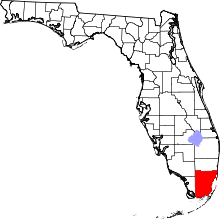
 Location in Miami-Dade County and the state of Florida | |
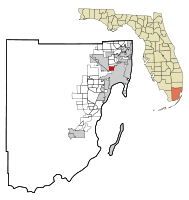
 U.S. Census Bureau map showing CDP boundaries | |
| Coordinates: 25°49′17″N 80°14′25″W / 25.82139°N 80.24028°WCoordinates: 25°49′17″N 80°14′25″W / 25.82139°N 80.24028°W | |
| Country |
|
| State |
|
| County | Miami-Dade |
| Area | |
| • Total | 2.3 sq mi (5.9 km2) |
| • Land | 2.3 sq mi (5.9 km2) |
| • Water | 0 sq mi (0 km2) |
| Elevation | 10 ft (3 m) |
| Population (2000) | |
| • Total | 14,393 |
| • Density | 6,257.8/sq mi (2,439.5/km2) |
| Time zone | Eastern (EST) (UTC-5) |
| • Summer (DST) | EDT (UTC-4) |
| Area code(s) | 305 |
| FIPS code | 12-09000[1] |
| GNIS feature ID | 1867121[2] |
- For the community near Pensacola, see Brownsville, Escambia County, Florida.
Brownsville, (also known as Brown Sub), is a census-designated place in metropolitan Miami, Florida, United States. As of the 2010 census, the population was 15,313, up from 14,393 in 2000. After three decades of population loss, Brownsville gained population for the first time in over 40 years in the 2010 US Census.
History
Brownsville was originally a settlement for White families in the 1920s. Blacks began moving into the neighborhood between the late 1940s and early 1960s as the population surrounding nearby Liberty Square expanded and many inner-city Whites moved to newly built suburban subdivisions surrounding Miami city proper in the wake of World War II.
By the mid-1960s, Brownsville was a thriving community for black professionals. However, the wake of the Civil Rights Act of 1968 (which outlawed the restrictive housing covenants which prevented most Blacks from moving to suburbs) and riots during the 1968 Republican National Convention brought the black flight of middle- and upper-class families from the community. Brownsville experienced continued population loss from 1970 until 2000, following a greater American suburbanization trend of among similar, upwardly-mobile demographics. By the 2010 US Census, Brownsville had gained population for the first time in over 40 years, rising to 15,313 residents.[3]
In June 2010, construction began on a new transit oriented development, "Brownsville Transit Village", on the 5.8-acre Brownsville Metrorail station parking lot. The project cost $100 million to build, and is composed of 467 units in five high-rise residential towers with ground-floor retail centered around the Brownsville Metro station. The project was partially funded by the 'American Reinvestment and Recovery Act of 2009', and is one of the largest transit oriented development and affordable housing projects in Miami.[4][5]
In 2011, growing local resident and community efforts to improve Brownsville, have greatly improved the neighborhood, with the construction of new apartment buildings, upkeep of existing homes, and lowering crime rates in the neighborhood.[3] Along the NW 27th Avenue Metro rail corridor, new buildings are being added such as the Jessie Trice Corporate & Community Health Complex and longtime businesses such as the Miami Jewish Health Systems (Douglas Gardens)Thrift Store next door and the KFC at 62nd Street have completed major property renovations/remodeling projects to improve and contribute to the revitalization efforts.
Geography
Brownsville is located at 25°49′17″N 80°14′25″W / 25.82139°N 80.24028°W (25.821275, -80.240220).[6]
According to the United States Census Bureau, the Census-designated place (CDP) has a total area of 2.3 square miles (6.0 km2), all of it land.
Demographics
| Historical population | |||
|---|---|---|---|
| Census | Pop. | %± | |
| 1970 | 23,442 | — | |
| 1980 | 18,058 | −23.0% | |
| 1990 | 15,607 | −13.6% | |
| 2000 | 14,393 | −7.8% | |
| 2010 | 15,313 | 6.4% | |
| source:[7][8] | |||
As of the census[1] of 2000, there were 14,393 people, 4,814 households, and 3,254 families residing in the CDP. The population density was 6,275.1 people per square mile (2,426.7/km²). There were 5,506 housing units at an average density of 2,400.5/sq mi (928.3/km²). The racial makeup of the CDP was 91.23% African American, 5.76% White, 0.22% Native American, 0.02% Asian, 0.01% Pacific Islander, 1.45% from other races, and 1.30% from two or more races. Hispanic or Latino of any race were 8.22% of the population.
There were 4,814 households out of which 34.3% had children under the age of 18 living with them, 21.1% were married couples living together, 39.2% had a female householder with no husband present, and 32.4% were non-families. 27.9% of all households were made up of individuals and 12.7% had someone living alone who was 65 years of age or older. The average household size was 2.98 and the average family size was 3.66.
In the CDP the population was spread out with 35.0% under the age of 18, 10.0% from 18 to 24, 25.7% from 25 to 44, 17.4% from 45 to 64, and 11.9% who were 65 years of age or older. The median age was 29 years. For every 100 females there were 83.7 males. For every 100 females age 18 and over, there were 75.2 males.
The median income for a household in the CDP was $16,902, and the median income for a family was $19,703. Males had a median income of $21,098 versus $21,182 for females. The per capita income for the CDP was $9,722. About 37.4% of families and 42.7% of the population were below the poverty line, including 54.6% of those under age 18 and 33.2% of those age 65 or over.
As of 2000, speakers of English as a first language accounted for 89.22% of residents, while Spanish made up 10.22% of the population, and French Creole made up 0.53% of all residents.[9]
Education
Miami-Dade County Public Schools operates area public schools.[10]
Elementary schools
- Lorah Park Elementary School
- Kelsey L. Pharr Elementary School
- Olinda Elementary School
- Earlington Heights Elementary School
- Charles Drew Elementary School
Middle schools
- Brownsville Middle School
- Charles Drew Middle School
- Miami Springs Middle School
High schools
- Miami Northwestern Senior High School
- Miami Jackson Senior High School
- Miami Springs Senior High School
Libraries
Miami-Dade Public Library operates area public libraries:
- Model City Library
Transportation
Brownsville is served by Miami-Dade Transit along major thoroughfares via Metrobus, and by the Miami Metrorail, Tri-Rail, and Amtrak at:
Metrorail:
- Brownsville (North 54th Street and West 27th Avenue)
- Dr. Martin Luther King Jr. Plaza (North 62nd Street and West 27th Avenue)
Tri-Rail:
- Tri-Rail/Metrorail Transfer (North 79th Street and West 37th Avenue)
- Hialeah Market (North 41st Street and NW 38th Avenue)
Amtrak:
- Amtrak-Miami: Silver Star and Silver Meteor service, (North 79th Street and West 37th Avenue)
References
- 1 2 "American FactFinder". United States Census Bureau. Archived from the original on 2013-09-11. Retrieved 2008-01-31.
- ↑ "US Board on Geographic Names". United States Geological Survey. 2007-10-25. Retrieved 2008-01-31.
- 1 2 http://www.miamiherald.com/2011/06/21/v-fullstory/2277104/brownsville-residents-work-to.html
- ↑ http://www.globest.com/news/1686_1686/miami/300426-1.html
- ↑ "Groundbreaking set for $100M Brownsville project". 2010-06-22.
- ↑ "US Gazetteer files: 2010, 2000, and 1990". United States Census Bureau. 2011-02-12. Retrieved 2011-04-23.
- ↑ "CENSUS OF POPULATION AND HOUSING (1790-2000)". U.S. Census Bureau. Retrieved 2010-07-17.
- ↑ Census area returned as Browns Village in 1970.
- ↑ "MLA Data Center Results of Brownsville, FL". Modern Language Association. Retrieved 2007-11-05.
- ↑ "Brownsville CDP, Florida Archived June 6, 2011, at the Wayback Machine.." U.S. Census Bureau. Retrieved on May 15, 2010.