Glenvar Heights, Florida
| Glenvar Heights, Florida | |
|---|---|
| CDP | |
|
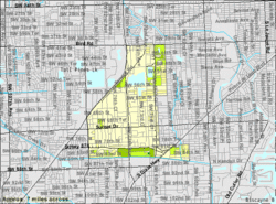
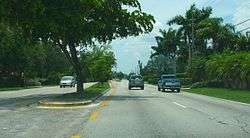
Sunset Drive westbound, just west of the Palmetto Expressway in Glenvar Heights, Florida, July 2008. | |
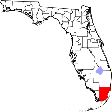
 Location in Miami-Dade County and the state of Florida | |
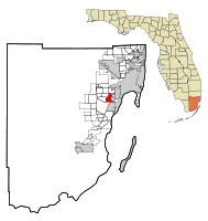
 U.S. Census Bureau map showing CDP boundaries | |
| Coordinates: 25°42′31″N 80°18′49″W / 25.70861°N 80.31361°WCoordinates: 25°42′31″N 80°18′49″W / 25.70861°N 80.31361°W | |
| Country |
|
| State |
|
| County | Miami-Dade |
| Area | |
| • Total | 4.4 sq mi (11.4 km2) |
| • Land | 4.2 sq mi (10.9 km2) |
| • Water | 0.2 sq mi (0.5 km2) |
| Elevation | 13 ft (4 m) |
| Population (2000) | |
| • Total | 16,243 |
| • Density | 3,691.6/sq mi (1,424.8/km2) |
| Time zone | Eastern (EST) (UTC-5) |
| • Summer (DST) | EDT (UTC-4) |
| FIPS code | 12-26100[1] |
| GNIS feature ID | 0283117[2] |
Glenvar Heights is a census-designated place (CDP) and affluent neighborhood in Miami-Dade County, Florida, United States. The population was 16,898 at the 2010 census.
Geography
Glenvar Heights is located at 25°42′31″N 80°18′49″W / 25.70861°N 80.31361°W (25.708579, -80.313477).[3]
According to the United States Census Bureau, the CDP has a total area of 4.4 square miles (11 km2), of which, 4.2 square miles (11 km2) of it is land and 0.2 square miles (0.52 km2) of it (4.11%) is water.
Demographics
As of the census[1] of 2000, there were 16,243 people, 7,243 households, and 3,947 families residing in the CDP. The population density was 3,858.5 people per square mile (1,489.7/km²). There were 7,591 housing units at an average density of 1,803.2/sq mi (696.2/km²). The racial makeup of the CDP was 87.71% White (37.9% were Non-Hispanic White,)[4] 3.00% African American, 0.19% Native American, 2.91% Asian, 0.06% Pacific Islander, 3.42% from other races, and 2.72% from two or more races. Hispanic or Latino of any race were 55.46% of the population.
There were 7,243 households out of which 23.1% had children under the age of 18 living with them, 38.9% were married couples living together, 11.6% had a female householder with no husband present, and 45.5% were non-families. 34.9% of all households were made up of individuals and 9.5% had someone living alone who was 65 years of age or older. The average household size was 2.24 and the average family size was 2.95.
In the CDP the population was spread out with 18.2% under the age of 18, 11.1% from 18 to 24, 33.7% from 25 to 44, 23.2% from 45 to 64, and 13.7% who were 65 years of age or older. The median age was 37 years. For every 100 females there were 87.6 males. For every 100 females age 18 and over, there were 84.8 males.
The median income for a household in the CDP was $40,209, and the median income for a family was $53,279. Males had a median income of $35,867 versus $30,510 for females. The per capita income for the CDP was $27,473. About 7.7% of families and 12.7% of the population were below the poverty line, including 10.7% of those under age 18 and 11.8% of those age 65 or over.
As of 2000, speakers of Spanish as a first language accounted for 60.96% of residents, while English made up 35.18%, French was at 1.01%, Arabic at 0.60%, and Portuguese consisted of 0.54% of the population.[5]
Transportation
Dadeland North station straddles the border of Glenvar Heights and Kendall CDPs.[6][7][8]
Education
Miami-Dade County Public Schools operates public schools.
References
- 1 2 "American FactFinder". United States Census Bureau. Retrieved 2008-01-31.
- ↑ "US Board on Geographic Names". United States Geological Survey. 2007-10-25. Retrieved 2008-01-31.
- ↑ "US Gazetteer files: 2010, 2000, and 1990". United States Census Bureau. 2011-02-12. Retrieved 2011-04-23.
- ↑ "Demographics of Glenvar Heights, FL". MuniNetGuide.com. Retrieved 2007-11-06.
- ↑ "MLA Data Center Results of Glenvar Heights, FL". Modern Language Association. Retrieved 2007-11-06.
- ↑ "2010 CENSUS - CENSUS BLOCK MAP (INDEX): Kendall CDP, FL" (Archive). U.S. Census Bureau. Retrieved on June 26, 2015. See detail in section 2 (Archive) - areas in pink are the Kendall CDP
- ↑ "2010 CENSUS - CENSUS BLOCK MAP: Glenvar Heights CDP, FL" (Archive). U.S. Census Bureau. Retrieved on January 3, 2015.
- ↑ "Metrorail Stations." Miami-Dade County. Retrieved on January 3, 2015. "Dadeland North[...]Station Address: 8300 South Dixie Highway"