Itoman, Okinawa
| Itoman 糸満市 Ichuman | |||
|---|---|---|---|
| City | |||
|
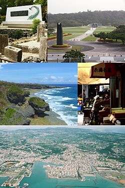
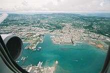
Clockwise from top left:Cenotaph of Himeyuri, Okinawa Peace Memorial Square, Itoman Central Market, Aerial in Itoman City, View of Akasaki from Cape Kyan | |||
| |||
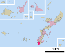 Location of Itoman in Okinawa Prefecture | |||
 Itoman
| |||
| Coordinates: 26°7′25″N 127°39′57″E / 26.12361°N 127.66583°ECoordinates: 26°7′25″N 127°39′57″E / 26.12361°N 127.66583°E | |||
| Country | Japan | ||
| Region | Kyushu | ||
| Prefecture | Okinawa Prefecture | ||
| Government | |||
| • Mayor | Hirotsune Uehara | ||
| Area | |||
| • Total | 46.63 km2 (18.00 sq mi) | ||
| Population (April, 2013) | |||
| • Total | 59,605 | ||
| • Density | 1,300/km2 (3,300/sq mi) | ||
| Time zone | Japan Standard Time (UTC+9) | ||
| - Tree | Banyan tree | ||
| - Flower | Madagascar Periwinkle | ||
| - Flowering tree | Bougainvillea | ||
| - Fish | Spangled emperor | ||
| Phone number | 098-840-8111 | ||
| Address |
1-1 Shiozaki-cho, Itoman-shi, Okinawa Prefecture 901-0392 | ||
| Website |
www | ||


Itoman (糸満市 Itoman-shi, Okinawan: Ichuman) is a city located in Okinawa Prefecture, Japan. The city sits at the southern tip of Okinawa Island.
As of April 2013, the city has an estimated population of 59,605 and a population density of 1,335.53 persons per km².[1] The total area is 46.63 km².[2][3]
Geography
Itoman sits on a flat tableland with craggy rolling hills of Ryukyuan limestone which range between Cape Kyan to the south and Yozadake to the north. The south of the town is known for its steep sea cliffs around Cape Kyan and the Mabuni Cliffs.[3]
History
Itoman has a long history as a fishing port. In the pre-modern period its fisherman ventured as far as the Indian Ocean. Records indicate that the fisherman made contact with Australia and New Guinea. By 1908 the village of Itoman numbered 8,000 residents, almost all involved in the fishing industry. Men of Itoman worked on fishing boats, and women worked at the transport and sale of fish in the prefectural capitol of Naha. In 1918 Naha and Itoman were connected by a horse-drawn tram. The line spanned 12 kilometres (7.5 mi). The Okinawa Prefectural Railways Itoman Line was established in 1924, and operated until 1945.[2][3]
Itoman was a final front of the Battle of Okinawa in World War II. The area saw enormous casualties to both military forces and civilians. Itoman is noted for the Himeyuri Butai, a field hospital nursing corps of 221 high-school students who committed suicide at the end of the battle.[2][4]
Administrative history
Itoman was established as a town in 1908. In 1961 it absorbed the villages of Kanegusuku, Takamine, and Miwa. Itoman was elevated to city status on December 1, 1971.[3]
Government
Itoman is administered from the city hall in Shiozaki. The Itoman Board of Education oversees the preschool, elementary, and middle school, community education centers, and sports facilities of the city. The Itoman City Council consists of 23 members who serve a four-year term, and are led by a chairperson (Isao Uehara) and vice-chairperson (Isao Tokuzato) of the council.
Economy
Fishing remains the primary industry of the city of Itoman.[2]
Transportation
Roads
Japan National Route 331, which connects Naha and Ōgimi along the eastern coast of Okinawa Island, runs through Itoman and connects the city to other municipalities in Okinawa.[3]
See also
References
- ↑ 統計情報 [Statistical Information] (in Japanese). Itoman, Okinawa Prefecture, Japan: City of Itowan. 2013. Retrieved 2013-06-25.
- 1 2 3 4 "Itoman". Encyclopedia of Japan. Tokyo: Shogakukan. 2013. OCLC 56431036. Retrieved 2013-06-25.
- 1 2 3 4 5 "糸満(市)" [Itoman]. Nihon Daihyakka Zensho (Nipponika) (in Japanese). Tokyo: Shogakukan. 2012. OCLC 153301537. Retrieved 2012-12-14.
- ↑ "Himeyuri Butai". Encyclopedia of Japan. Tokyo: Shogakukan. 2013. OCLC 56431036. Retrieved 2013-06-25.
External links
| Wikimedia Commons has media related to Itoman, Okinawa. |
| Wikivoyage has a travel guide for Itoman. |
- Itoman City official website (Japanese)
- Itoman City official website
- News of Okinawa in WEB RADIO (Portuguese)
- Okinawa Prefectural Peace Memorial Museum
- Himeyuri Monument(Monument for high school girls who died in WWII)
- Cornerstone of Peace
- Mabuni Hill